Atchison County, Missouri
| Atchison County, Missouri | |
|---|---|
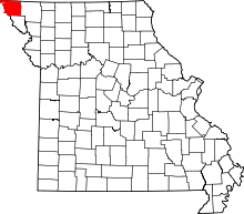 Location in the U.S. state of Missouri | |
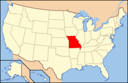 Missouri's location in the U.S. | |
| Founded | February 14, 1845 |
| Named for | David Rice Atchison |
| Seat | Rock Port |
| Largest city | Tarkio |
| Area | |
| • Total | 550 sq mi (1,424 km2) |
| • Land | 547 sq mi (1,417 km2) |
| • Water | 2.8 sq mi (7 km2), 0.5 |
| Population (est.) | |
| • (2015) | 5,306 |
| • Density | 10/sq mi (4/km²) |
| Congressional district | 6th |
| Time zone | Central: UTC-6/-5 |
| Website |
www |
Atchison County is the northwestern-most county in the U.S. state of Missouri. As of the 2010 census, the county had a population of 5,685.[1] Its county seat is Rock Port.[2] It was originally known as Allen County when it was detached from Holt County in 1843.[3] The county was officially organized on February 14, 1845 and named for U.S. Senator David Rice Atchison from Missouri.[4]
Geography
According to the U.S. Census Bureau, the county has a total area of 550 square miles (1,400 km2), of which 547 square miles (1,420 km2) is land and 2.8 square miles (7.3 km2) (0.5%) is water.[5]
Atchison's western boundary for the most part is the Missouri River and Nebraska. An 1867 flood straightened a bend in the river north of Watson. Both Nebraska and Missouri claimed the 5,000 acre McKissick Island that extends almost two miles into Atchison County. The Supreme Court in 1904 decided that the land belongs to Nebraska. The only way Nebraskans can reach it by road is to cross the Missouri River and then travel through Missouri.[6]
Adjacent counties
- Fremont County, Iowa (north)
- Page County, Iowa (northeast)
- Nodaway County (east)
- Holt County (south)
- Richardson County, Nebraska (southwest)
- Nemaha County, Nebraska (west)
- Otoe County, Nebraska (northwest)
Major highways
Demographics
| Historical population | |||
|---|---|---|---|
| Census | Pop. | %± | |
| 1850 | 1,678 | — | |
| 1860 | 4,649 | 177.1% | |
| 1870 | 8,440 | 81.5% | |
| 1880 | 14,556 | 72.5% | |
| 1890 | 15,533 | 6.7% | |
| 1900 | 16,501 | 6.2% | |
| 1910 | 13,604 | −17.6% | |
| 1920 | 13,008 | −4.4% | |
| 1930 | 13,421 | 3.2% | |
| 1940 | 12,897 | −3.9% | |
| 1950 | 11,127 | −13.7% | |
| 1960 | 9,213 | −17.2% | |
| 1970 | 9,240 | 0.3% | |
| 1980 | 8,605 | −6.9% | |
| 1990 | 7,457 | −13.3% | |
| 2000 | 6,430 | −13.8% | |
| 2010 | 5,685 | −11.6% | |
| Est. 2015 | 5,306 | [7] | −6.7% |
| U.S. Decennial Census[8] 1790-1960[9] 1900-1990[10] 1990-2000[11] 2010-2015[1] | |||
As of the census[12] of 2000, there were 6,430 people, 2,722 households, and 1,777 families residing in the county. The population density was 12 people per square mile (5/km²). There were 3,103 housing units at an average density of 6 per square mile (2/km²). The racial makeup of the county was 97.00% White, 2.05% Black or African American, 0.19% Native American, 0.14% Asian, 0.31% from other races, and 0.31% from two or more races. Approximately 0.67% of the population were Hispanic or Latino of any race.
There were 2,722 households out of which 26.60% had children under the age of 18 living with them, 55.80% were married couples living together, 6.10% had a female householder with no husband present, and 34.70% were non-families. 31.50% of all households were made up of individuals and 17.60% had someone living alone who was 65 years of age or older. The average household size was 2.25 and the average family size was 2.82.
In the county the population was spread out with 24.10% under the age of 18, 6.50% from 18 to 24, 24.20% from 25 to 44, 24.20% from 45 to 64, and 21.10% who were 65 years of age or older. The median age was 42 years. For every 100 females there were 99.30 males. For every 100 females age 18 and over, there were 91.90 males.
The median income for a household in the county was $30,959, and the median income for a family was $38,279. Males had a median income of $27,468 versus $18,855 for females. The per capita income for the county was $16,956. About 9.30% of families and 11.60% of the population were below the poverty line, including 13.70% of those under age 18 and 12.40% of those age 65 or over.
Education
Public Schools
- Fairfax R-III School District – Fairfax
- Fairfax Elementary School (PK-06)
- Fairfax High School (07-12)
- Rock Port R-II School District – Rock Port
- Rock Port Elementary School (K-06)
- Rock Port High School (07-12)
- Tarkio R-I School District – Tarkio
- Tarkio Elementary School (PK-06)
- Tarkio High School (07-12)
Private Schools
- Tarkio Academy – Tarkio (07-12) – Nonsectarian (All Boys)-closed
Politics
Local
| Atchison County, Missouri | ||||
|---|---|---|---|---|
| Elected countywide officials | ||||
| Assessor | Lori Brown Jones | Democratic | ||
| Circuit Clerk | Lorie Hall | Republican | ||
| County Clerk | Susette M. Taylor | Republican | ||
| Collector | Diane Livengood | Republican | ||
| Commissioner (Presiding) |
Curtis Livengood | Republican | ||
| Commissioner (District 1) |
David P. Chapin | Republican | ||
| Commissioner (District 2) |
Richard C. Burke | Democratic | ||
| Coroner | Shawn Minter, Jr. | Republican | ||
| Prosecuting Attorney | Dan Smith | Independent | ||
| Public Administrator | Teresa Jayne Scott | Republican | ||
| Recorder | Lorie Hall | Republican | ||
| Sheriff | Dennis D. Martin | Democratic | ||
| Surveyor | Adam Teale | Republican | ||
| Treasurer | Debbie True | Republican | ||
State
| Year | Republican | Democratic | Third Parties |
|---|---|---|---|
| 2012 | 49.83% 1,319 | 46.85% 1,240 | 3.32% 88 |
| 2008 | 45.93% 1,336 | 50.22% 1,461 | 3.85% 112 |
| 2004 | 63.65% 1,973 | 34.90% 1,082 | 1.45% 45 |
| 2000 | 57.05% 1,610 | 41.42% 1,169 | 1.53% 43 |
| 1996 | 37.36% 1,111 | 61.13% 1,818 | 1.51% 45 |
| 1992 | 50.70% 1,604 | 49.30% 1,560 | 0.00% 0 |
All of Atchison County is a part of Missouri’s 1st District in the Missouri House of Representatives and is represented by Allen Andrews (R-Grant City).
All of Atchison County is a part of Missouri’s 12th District in the Missouri Senate and is currently represented by Dan Hegeman (R-Cosby).
Federal
| Party | Candidate | Votes | % | ± | |
|---|---|---|---|---|---|
| Republican | Todd Akin | 1,340 | 50.30 | ||
| Democratic | Claire McCaskill | 1,155 | 43.36 | ||
| Libertarian | Jonathan Dine | 169 | 6.34 | ||
All of Atchison County is included in Missouri’s 6th Congressional District and is currently represented by Sam Graves (R-Tarkio) in the U.S. House of Representatives.
| Party | Candidate | Votes | % | ± | |
|---|---|---|---|---|---|
| Republican | Sam B. Graves | 1,313 | 73.03 | ||
| Democratic | Bill Hedge | 407 | 22.64 | ||
| Libertarian | Russ Monchil | 78 | 4.34 | ||
| Year | Republican | Democratic | Third Parties |
|---|---|---|---|
| 2012 | 70.21% 1,902 | 27.91% 756 | 1.88% 51 |
| 2008 | 65.05% 1,936 | 33.60% 1,000 | 1.35% 40 |
| 2004 | 67.71% 2,137 | 31.84% 1,005 | 0.44% 14 |
| 2000 | 62.63% 1,798 | 35.28% 1,013 | 2.09% 60 |
| 1996 | 44.56% 1,327 | 42.51% 1,266 | 12.93% 385 |
| 1992 | 35.64% 1,140 | 37.76% 1,208 | 26.60% 851 |
Missouri Presidential Preference Primary (2008)
- Former U.S. Senator and current U.S. Secretary of State Hillary Clinton (D-New York) received more votes, a total of 347, than any candidate from either party in Atchison County during the 2008 presidential primary.
| Atchison County, Missouri | ||
|---|---|---|
| 2008 Republican primary in Missouri | ||
| John McCain | 281 (37.92%) | |
| Mike Huckabee | 189 (25.51%) | |
| Mitt Romney | 230 (31.04%) | |
| Ron Paul | 25 (3.37%) | |
| Atchison County, Missouri | ||
|---|---|---|
| 2008 Democratic primary in Missouri | ||
| Hillary Clinton | 347 (54.73%) | |
| Barack Obama | 262 (41.32%) | |
| John Edwards (withdrawn) | 15 (2.37%) | |
| Uncommitted | 7 (1.10%) | |
Communities
Cities
Village
Census-designated places
Unincorporated community
Townships
Atchison County is divided into 11 townships:
Notable residents
- Michael J. Burg - Actor
- Zel Fischer - Missouri Supreme Court Justice
- Sam Graves - U.S. Representative for Missouri's 6th Congressional District
See also
References
- 1 2 "State & County QuickFacts". United States Census Bureau. Retrieved September 7, 2013.
- ↑ "Find a County". National Association of Counties. Archived from the original on 2011-05-31. Retrieved 2011-06-07.
- ↑ "Disappearing Missouri Names". The Kansas City Star. March 19, 1911. p. 15. Retrieved August 15, 2014 – via Newspapers.com.

- ↑ Eaton, David Wolfe (1916). How Missouri Counties, Towns and Streams Were Named. The State Historical Society of Missouri. p. 202.
- ↑ "2010 Census Gazetteer Files". United States Census Bureau. August 22, 2012. Retrieved November 13, 2014.
- ↑ https://docs.google.com/viewer?a=v&q=cache:jxQJS0nNWG4J:www.midlandsurvey.com/Downloads/MS_McKissickIsland_NationalArchive_2010.pdf+&hl=en&gl=us&pid=bl&srcid=ADGEEShfS9h3cA9u0GilN1vitrrU5l6JQgYcuzzJeAkLdhNiw1QKXX0mvbusIW0f0GslfY314UOK1NUsWPNzXiw3ASZ2Qp142OVqyy1BaE9SvFdnSnS6KM2M8mgXkeOyyji2sXbfs_l2&sig=AHIEtbRGueCR6Zt2VK4-7Gv4dZA4sN4Glg
- ↑ "County Totals Dataset: Population, Population Change and Estimated Components of Population Change: April 1, 2010 to July 1, 2015". Retrieved July 2, 2016.
- ↑ "U.S. Decennial Census". United States Census Bureau. Archived from the original on May 11, 2015. Retrieved November 13, 2014.
- ↑ "Historical Census Browser". University of Virginia Library. Retrieved November 13, 2014.
- ↑ "Population of Counties by Decennial Census: 1900 to 1990". United States Census Bureau. Retrieved November 13, 2014.
- ↑ "Census 2000 PHC-T-4. Ranking Tables for Counties: 1990 and 2000" (PDF). United States Census Bureau. Retrieved November 13, 2014.
- ↑ "American FactFinder". United States Census Bureau. Archived from the original on 2013-09-11. Retrieved 2011-05-14.
External links
- Digitized 1930 Plat Book of Atchison County from University of Missouri Division of Special Collections, Archives, and Rare Books
 |
Otoe County, Nebraska | Fremont County, Iowa | Page County, Iowa | |
| Nemaha County, Nebraska | |
Nodaway County | ||
| ||||
| | ||||
| Richardson County, Nebraska | Holt County |
Municipalities and communities of Atchison County, Missouri, United States | ||
|---|---|---|
| Cities | | |
| Village | ||
| Townships | ||
| CDPs | ||
| Unincorporated communities | ||
| Ghost towns | ||
Coordinates: 40°26′N 95°26′W / 40.43°N 95.43°W