Rock Port, Missouri
| Rock Port, Missouri | |
|---|---|
| City | |
 Location of Rock Port, Missouri | |
| Coordinates: 40°24′44″N 95°31′11″W / 40.41222°N 95.51972°WCoordinates: 40°24′44″N 95°31′11″W / 40.41222°N 95.51972°W | |
| Country | United States |
| State | Missouri |
| County | Atchison |
| Township | Clay |
| Area[1] | |
| • Total | 2.77 sq mi (7.17 km2) |
| • Land | 2.77 sq mi (7.17 km2) |
| • Water | 0 sq mi (0 km2) |
| Elevation | 942 ft (287 m) |
| Population (2010)[2] | |
| • Total | 1,318 |
| • Estimate (2012[3]) | 1,281 |
| • Density | 480/sq mi (180/km2) |
| Time zone | Central (CST) (UTC-6) |
| • Summer (DST) | CDT (UTC-5) |
| ZIP code | 64482 |
| Area code(s) | 660 |
| FIPS code | 29-62696 [4] |
| GNIS feature ID | 0730197 [5] |
| Website | rpmo.com |
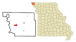
Rock Port is a city in, and the county seat of, Atchison County, Missouri, United States. The population was 1,318 at the 2010 census.
History
Rock Port was laid out in 1851.[6] The city, which is eight miles east of the Missouri River in the Loess Hills bluffs above the river, derives its name from Rock Creek, which flows through it. It was originally named Linden.[7]
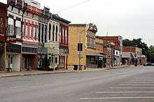
The original city is off the interstate, but an additional area is built that is a travel hub. Truck stops, motels, fast food and firework stands are located along the interstate hosting a large amount of day time visitors, despite the city's small size.
The city of Rock Port has become largely energy self-sufficient.[8] In April 2008, Rock Port claimed to be the first community in the United States to have its electricity 100 percent generated by wind power. Rock Port, which uses about 13 million kWh a year, has its power generated by the Loess Hills Wind Farm. The farm has four Suzlon 1.25-megawatt wind turbines. Excess power is sold to the Missouri Public Utility Alliance in Columbia, Missouri.[9] The idea for the wind turbines came from the town's former mortuary worker, Eric Chamberlain.[8] The farm was built by Wind Capital Group and is by far the company's smallest wind farm developed through January 2009. Wind Capital in 2008 built the bigger 50.4MW Cow Branch Wind Farm between Rock Port and Tarkio.
The Atchison County Memorial Building and John Dickinson Dopf Mansion are listed on the National Register of Historic Places.[10]
Geography
Rock Port is located at 40°24′44″N 95°31′11″W / 40.41222°N 95.51972°W (40.412268, -95.519792).[11] According to the United States Census Bureau, the city has a total area of 2.77 square miles (7.17 km2), all land.[1]
Demographics
| Historical population | |||
|---|---|---|---|
| Census | Pop. | %± | |
| 1860 | 305 | — | |
| 1870 | 490 | 60.7% | |
| 1880 | 715 | 45.9% | |
| 1890 | 934 | 30.6% | |
| 1900 | 1,080 | 15.6% | |
| 1910 | 1,053 | −2.5% | |
| 1920 | 1,136 | 7.9% | |
| 1930 | 1,162 | 2.3% | |
| 1940 | 1,406 | 21.0% | |
| 1950 | 1,511 | 7.5% | |
| 1960 | 1,310 | −13.3% | |
| 1970 | 1,575 | 20.2% | |
| 1980 | 1,511 | −4.1% | |
| 1990 | 1,438 | −4.8% | |
| 2000 | 1,395 | −3.0% | |
| 2010 | 1,318 | −5.5% | |
| Est. 2015 | 1,232 | [12] | −6.5% |
2010 census
As of the census[2] of 2010, there were 1,318 people, 588 households, and 356 families residing in the city. The population density was 475.8 inhabitants per square mile (183.7/km2). There were 667 housing units at an average density of 240.8 per square mile (93.0/km2). The racial makeup of the city was 98.2% White, 0.3% Native American, 0.1% from other races, and 1.4% from two or more races. Hispanic or Latino of any race were 1.9% of the population.
There were 588 households of which 26.9% had children under the age of 18 living with them, 46.8% were married couples living together, 9.7% had a female householder with no husband present, 4.1% had a male householder with no wife present, and 39.5% were non-families. 34.7% of all households were made up of individuals and 16.2% had someone living alone who was 65 years of age or older. The average household size was 2.15 and the average family size was 2.75.
The median age in the city was 46.3 years. 21.4% of residents were under the age of 18; 6.9% were between the ages of 18 and 24; 19.8% were from 25 to 44; 28.8% were from 45 to 64; and 23.1% were 65 years of age or older. The gender makeup of the city was 47.7% male and 52.3% female.
2000 census
As of the census[4] of 2000, there were 1,395 people, 647 households, and 368 families residing in the city. The population density was 488.5 people per square mile (188.3/km²). There were 714 housing units at an average density of 250.0 per square mile (96.4/km²). The racial makeup of the city was 99.35% White, 0.07% African American, 0.14% Native American, 0.22% from other races, and 0.22% from two or more races. Hispanic or Latino of any race were 0.50% of the population.
There were 647 households out of which 23.3% had children under the age of 18 living with them, 49.9% were married couples living together, 4.9% had a female householder with no husband present, and 43.0% were non-families. 40.2% of all households were made up of individuals and 26.3% had someone living alone who was 65 years of age or older. The average household size was 2.08 and the average family size was 2.79.
In the city the population was spread out with 20.9% under the age of 18, 5.3% from 18 to 24, 22.7% from 25 to 44, 22.9% from 45 to 64, and 28.2% who were 65 years of age or older. The median age was 46 years. For every 100 females there were 86.7 males. For every 100 females age 18 and over, there were 81.3 males.
The median income for a household in the city was $28,571, and the median income for a family was $41,625. Males had a median income of $27,639 versus $19,653 for females. The per capita income for the city was $18,322. About 7.2% of families and 11.6% of the population were below the poverty line, including 15.8% of those under age 18 and 12.1% of those age 65 or over.
Notable people
- Michael J. Burg (born 1968), actor
- Hardin Cox (1928–2013), politician and businessman[14]
- Loraine Boettner, American Protestant theologian
References
- 1 2 "US Gazetteer files 2010". United States Census Bureau. Retrieved 2012-07-08.
- 1 2 "American FactFinder". United States Census Bureau. Retrieved 2012-07-08.
- ↑ "Population Estimates". United States Census Bureau. Retrieved 2013-05-30.
- 1 2 "American FactFinder". United States Census Bureau. Retrieved 2008-01-31.
- ↑ "US Board on Geographic Names". United States Geological Survey. 2007-10-25. Retrieved 2008-01-31.
- ↑ Eaton, David Wolfe (1916). How Missouri Counties, Towns and Streams Were Named. The State Historical Society of Missouri. p. 203.
- ↑ "Disappearing Missouri Names". The Kansas City Star. March 19, 1911. p. 15. Retrieved August 15, 2014 – via Newspapers.com.

- 1 2 Missouri Town Is Running On Vapor — And Thriving, Frank Morris, August 9, 2008, National Public Radio; accessed August 10, 2008
- ↑ Rock Port to become first American 100 percent wind powered community - Maryville Daily Forum - April 13, 2008
- ↑ National Park Service (2010-07-09). "National Register Information System". National Register of Historic Places. National Park Service.
- ↑ "US Gazetteer files: 2010, 2000, and 1990". United States Census Bureau. 2011-02-12. Retrieved 2011-04-23.
- ↑ "Annual Estimates of the Resident Population for Incorporated Places: April 1, 2010 to July 1, 2015". Retrieved July 2, 2016.
- ↑ "Census of Population and Housing". Census.gov. Retrieved June 4, 2015.
- ↑ OurCampaigns.com-Hardin Cox
External links
- City of Rock Port
- Historic maps of Rock Port in the Sanborn Maps of Missouri Collection at the University of Missouri
Municipalities and communities of Atchison County, Missouri, United States | ||
|---|---|---|
| Cities | 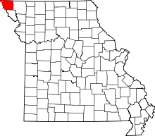 | |
| Village | ||
| Townships | ||
| CDPs | ||
| Unincorporated communities | ||
| Ghost towns | ||