Watson, Missouri
| Watson, Missouri | |
|---|---|
| Village | |
|
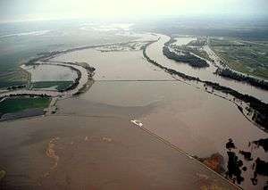
Flooding at the confluence of the Nishnabotna and Missouri Rivers on June 16, 2011, during the 2011 Missouri River floods | |
 Location of Watson, Missouri | |
| Coordinates: 40°28′44″N 95°37′26″W / 40.47889°N 95.62389°WCoordinates: 40°28′44″N 95°37′26″W / 40.47889°N 95.62389°W | |
| Country | United States |
| State | Missouri |
| County | Atchison |
| Township | Nishnabotna |
| Area[1] | |
| • Total | 0.11 sq mi (0.28 km2) |
| • Land | 0.11 sq mi (0.28 km2) |
| • Water | 0 sq mi (0 km2) |
| Elevation | 899 ft (274 m) |
| Population (2010)[2] | |
| • Total | 100 |
| • Estimate (2012[3]) | 97 |
| • Density | 909.1/sq mi (351.0/km2) |
| Time zone | Central (CST) (UTC-6) |
| • Summer (DST) | CDT (UTC-5) |
| ZIP code | 64496 |
| Area code(s) | 660 |
| FIPS code | 29-77848[4] |
| GNIS feature ID | 0728422[5] |
Watson is a village in Nishnabotna Township, Atchison County, Missouri, United States. The population was 100 at the 2010 census. It is the westernmost settlement in the state of Missouri.
History
Watson was platted in 1869.[6] The village was named after a railroad official.[7] A post office was established at Watson in 1869, and remained in operation until 1965.[8]
Geography
Watson is located at 40°28′44″N 95°37′26″W / 40.47889°N 95.62389°W (40.478975, -95.623762).[9]
According to the United States Census Bureau, the village has a total area of 0.11 square miles (0.28 km2), all land.[1]
Demographics
| Historical population | |||
|---|---|---|---|
| Census | Pop. | %± | |
| 1870 | 75 | — | |
| 1880 | 213 | 184.0% | |
| 1890 | 238 | 11.7% | |
| 1900 | 233 | −2.1% | |
| 1910 | 245 | 5.2% | |
| 1920 | 227 | −7.3% | |
| 1930 | 223 | −1.8% | |
| 1940 | 269 | 20.6% | |
| 1950 | 199 | −26.0% | |
| 1960 | 181 | −9.0% | |
| 1970 | 164 | −9.4% | |
| 1980 | 171 | 4.3% | |
| 1990 | 137 | −19.9% | |
| 2000 | 121 | −11.7% | |
| 2010 | 100 | −17.4% | |
| Est. 2015 | 94 | [10] | −6.0% |
2010 census
As of the census[2] of 2010, there were 100 people, 40 households, and 28 families residing in the village. The population density was 909.1 inhabitants per square mile (351.0/km2). There were 47 housing units at an average density of 427.3 per square mile (165.0/km2). The racial makeup of the village was 100.0% White.
There were 40 households of which 30.0% had children under the age of 18 living with them, 50.0% were married couples living together, 12.5% had a female householder with no husband present, 7.5% had a male householder with no wife present, and 30.0% were non-families. 25.0% of all households were made up of individuals and 7.5% had someone living alone who was 65 years of age or older. The average household size was 2.50 and the average family size was 2.96.
The median age in the village was 38.7 years. 21% of residents were under the age of 18; 10% were between the ages of 18 and 24; 25% were from 25 to 44; 29% were from 45 to 64; and 15% were 65 years of age or older. The gender makeup of the village was 54.0% male and 46.0% female.
2000 census
As of the census[4] of 2000, there were 121 people, 40 households, and 32 families residing in the village. The population density was 1,136.4 people per square mile (424.7/km²). There were 58 housing units at an average density of 544.7 per square mile (203.6/km²). The racial makeup of the village was 99.17% White, and 0.83% from two or more races. Hispanic or Latino of any race were 2.48% of the population.
There were 40 households out of which 42.5% had children under the age of 18 living with them, 70.0% were married couples living together, 10.0% had a female householder with no husband present, and 20.0% were non-families. 17.5% of all households were made up of individuals and 5.0% had someone living alone who was 65 years of age or older. The average household size was 3.03 and the average family size was 3.38.
In the village the population was spread out with 26.4% under the age of 18, 12.4% from 18 to 24, 22.3% from 25 to 44, 29.8% from 45 to 64, and 9.1% who were 65 years of age or older. The median age was 39 years. For every 100 females there were 120.0 males. For every 100 females age 18 and over, there were 128.2 males.
The median income for a household in the village was $27,750, and the median income for a family was $28,500. Males had a median income of $28,594 versus $23,000 for females. The per capita income for the village was $13,753. There were 9.4% of families and 7.4% of the population living below the poverty line, including 15.2% of under eighteens and none of those over 64.
Notable person
Current Missouri Supreme Court Judge Zel Fischer grew up in Watson.
References
- 1 2 "US Gazetteer files 2010". United States Census Bureau. Retrieved 2012-07-08.
- 1 2 "American FactFinder". United States Census Bureau. Retrieved 2012-07-08.
- ↑ "Population Estimates". United States Census Bureau. Retrieved 2013-05-30.
- 1 2 "American FactFinder". United States Census Bureau. Retrieved 2008-01-31.
- ↑ "US Board on Geographic Names". United States Geological Survey. 2007-10-25. Retrieved 2008-01-31.
- ↑ Eaton, David Wolfe (1916). How Missouri Counties, Towns and Streams Were Named. The State Historical Society of Missouri. p. 203.
- ↑ "Atchison County Place Names, 1928-1945 (archived)". The State Historical Society of Missouri. Retrieved 30 August 2016.
- ↑ "Post Offices". Jim Forte Postal History. Retrieved 30 August 2016.
- ↑ "US Gazetteer files: 2010, 2000, and 1990". United States Census Bureau. 2011-02-12. Retrieved 2011-04-23.
- ↑ "Annual Estimates of the Resident Population for Incorporated Places: April 1, 2010 to July 1, 2015". Retrieved July 2, 2016.
- ↑ "Census of Population and Housing". Census.gov. Retrieved June 4, 2015.
Municipalities and communities of Atchison County, Missouri, United States | ||
|---|---|---|
| Cities | 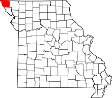 | |
| Village | ||
| Townships | ||
| CDPs | ||
| Unincorporated communities | ||
| Ghost towns | ||