Byers, Kansas
| Byers, Kansas | |
|---|---|
| City | |
 Location within Pratt County and Kansas | |
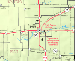 KDOT map of Pratt County (legend) | |
| Coordinates: 37°47′16″N 98°52′2″W / 37.78778°N 98.86722°WCoordinates: 37°47′16″N 98°52′2″W / 37.78778°N 98.86722°W | |
| Country | United States |
| State | Kansas |
| County | Pratt |
| Area[1] | |
| • Total | 0.19 sq mi (0.49 km2) |
| • Land | 0.19 sq mi (0.49 km2) |
| • Water | 0 sq mi (0 km2) |
| Elevation | 2,008 ft (612 m) |
| Population (2010)[2] | |
| • Total | 35 |
| • Estimate (2015)[3] | 35 |
| • Density | 180/sq mi (71/km2) |
| Time zone | Central (CST) (UTC-6) |
| • Summer (DST) | CDT (UTC-5) |
| ZIP code | 67021 |
| Area code | 620 |
| FIPS code | 20-09800 [4] |
| GNIS feature ID | 0473763 [5] |
Byers is a city in Pratt County, Kansas, United States. As of the 2010 census, the city population was 35.[6]
History
Byers was founded in 1914. It was named for O. P. Byers.[7]
The first post office in Byers was established in April 1915.[8]
Geography
Byers is located at 37°47′16″N 98°52′2″W / 37.78778°N 98.86722°W (37.787830, -98.867114).[9] According to the United States Census Bureau, the city has a total area of 0.19 square miles (0.49 km2), all of it land.[1]
Demographics
| Historical population | |||
|---|---|---|---|
| Census | Pop. | %± | |
| 1920 | 212 | — | |
| 1930 | 185 | −12.7% | |
| 1940 | 153 | −17.3% | |
| 1950 | 83 | −45.8% | |
| 1960 | 52 | −37.3% | |
| 1970 | 46 | −11.5% | |
| 1980 | 47 | 2.2% | |
| 1990 | 46 | −2.1% | |
| 2000 | 50 | 8.7% | |
| 2010 | 35 | −30.0% | |
| Est. 2015 | 35 | [3] | 0.0% |
| U.S. Decennial Census | |||
2010 census
As of the census[2] of 2010, there were 35 people, 15 households, and 9 families residing in the city. The population density was 184.2 inhabitants per square mile (71.1/km2). There were 21 housing units at an average density of 110.5 per square mile (42.7/km2). The racial makeup of the city was 94.3% White and 5.7% from two or more races.
There were 15 households of which 26.7% had children under the age of 18 living with them, 46.7% were married couples living together, 6.7% had a female householder with no husband present, 6.7% had a male householder with no wife present, and 40.0% were non-families. 40.0% of all households were made up of individuals and 26.7% had someone living alone who was 65 years of age or older. The average household size was 2.33 and the average family size was 3.00.
The median age in the city was 43.5 years. 25.7% of residents were under the age of 18; 11.4% were between the ages of 18 and 24; 14.4% were from 25 to 44; 25.8% were from 45 to 64; and 22.9% were 65 years of age or older. The gender makeup of the city was 42.9% male and 57.1% female.
2000 census
As of the census[4] of 2000, there were 50 people, 20 households, and 18 families residing in the city. The population density was 272.1 people per square mile (107.3/km²). There were 20 housing units at an average density of 108.8 per square mile (42.9/km²). The racial makeup of the city was 100.00% White. Hispanic or Latino of any race were 8.00% of the population.
There were 20 households out of which 35.0% had children under the age of 18 living with them, 70.0% were married couples living together, 15.0% had a female householder with no husband present, and 10.0% were non-families. 10.0% of all households were made up of individuals and 5.0% had someone living alone who was 65 years of age or older. The average household size was 2.50 and the average family size was 2.67.
In the city the population was spread out with 30.0% under the age of 18, 4.0% from 18 to 24, 24.0% from 25 to 44, 30.0% from 45 to 64, and 12.0% who were 65 years of age or older. The median age was 37 years. For every 100 females there were 72.4 males. For every 100 females age 18 and over, there were 84.2 males.
The median income for a household in the city was $18,125, and the median income for a family was $18,125. Males had a median income of $21,250 versus $21,250 for females. The per capita income for the city was $8,461. There were 47.4% of families and 36.7% of the population living below the poverty line, including 18.8% of under eighteens and 100.0% of those over 64.
Education
Byers High School (called the Hornets) became defunct in 1966, after which time its students were bussed to a regional rural community outside Pratt, called Skyline High School.
References
- 1 2 "US Gazetteer files 2010". United States Census Bureau. Archived from the original on 2012-01-24. Retrieved 2012-07-06.
- 1 2 "American FactFinder". United States Census Bureau. Retrieved 2012-07-06.
- 1 2 "Annual Estimates of the Resident Population for Incorporated Places: April 1, 2010 to July 1, 2015". Retrieved July 2, 2016.
- 1 2 "American FactFinder". United States Census Bureau. Archived from the original on 2013-09-11. Retrieved 2008-01-31.
- ↑ "US Board on Geographic Names". United States Geological Survey. 2007-10-25. Retrieved 2008-01-31.
- ↑ "2010 City Population and Housing Occupancy Status". U.S. Census Bureau. Archived from the original on July 21, 2011. Retrieved September 18, 2011.
- ↑ Kansas State Historical Society (1916). Biennial Report of the Board of Directors of the Kansas State Historical Society. Kansas State Printing Plant. p. 265.
- ↑ "Kansas Post Offices, 1828-1961". Kansas Historical Society. Archived from the original on October 9, 2013. Retrieved 22 June 2014.
- ↑ "US Gazetteer files: 2010, 2000, and 1990". United States Census Bureau. 2011-02-12. Retrieved 2011-04-23.
External links
| Wikimedia Commons has media related to Byers, Kansas. |
- City
- Schools
- USD 438, local school district
- Maps
- Byers City Map, KDOT
Municipalities and communities of Pratt County, Kansas, United States | ||
|---|---|---|
| Cities | 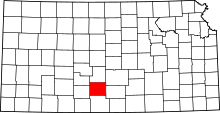 | |
| Unincorporated communities | ||