Preston, Kansas
| Preston, Kansas | |
|---|---|
| City | |
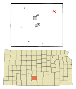 Location within Pratt County and Kansas | |
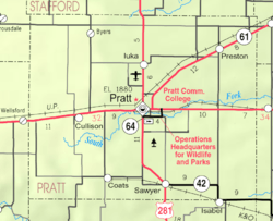 KDOT map of Pratt County (legend) | |
| Coordinates: 37°45′36″N 98°33′16″W / 37.76000°N 98.55444°WCoordinates: 37°45′36″N 98°33′16″W / 37.76000°N 98.55444°W | |
| Country | United States |
| State | Kansas |
| County | Pratt |
| Area[1] | |
| • Total | 0.47 sq mi (1.22 km2) |
| • Land | 0.47 sq mi (1.22 km2) |
| • Water | 0 sq mi (0 km2) |
| Elevation | 1,834 ft (559 m) |
| Population (2010)[2] | |
| • Total | 158 |
| • Estimate (2015)[3] | 160 |
| • Density | 340/sq mi (130/km2) |
| Time zone | Central (CST) (UTC-6) |
| • Summer (DST) | CDT (UTC-5) |
| FIPS code | 20-57675 [4] |
| GNIS feature ID | 0473767 [5] |
Preston is a city in Pratt County, Kansas, United States. As of the 2010 census, the city population was 158.[6] Preston was founded in 1887.[7]
History
19th century
In 1887, the Chicago, Kansas and Nebraska Railway built a main line from Herington through Preston to Pratt.[8] In 1888, this line was extended to Liberal. Later, it was extended to Tucumcari, New Mexico and El Paso, Texas. It foreclosed in 1891 and taken over by Chicago, Rock Island and Pacific Railway, which shut down in 1980 and reorganized as Oklahoma, Kansas and Texas Railroad, merged in 1988 with Missouri Pacific Railroad, merged in 1997 with Union Pacific Railroad. Most locals still refer to this railroad as the "Rock Island".
Preston had a post office from 1887 until 1990.[9]
Geography
Preston is located at 37°45′36″N 98°33′16″W / 37.76000°N 98.55444°W (37.759981, -98.554549).[10] According to the United States Census Bureau, the city has a total area of 0.47 square miles (1.22 km2), all of it land.[1]
Demographics
| Historical population | |||
|---|---|---|---|
| Census | Pop. | %± | |
| 1910 | 278 | — | |
| 1920 | 401 | 44.2% | |
| 1930 | 383 | −4.5% | |
| 1940 | 328 | −14.4% | |
| 1950 | 307 | −6.4% | |
| 1960 | 278 | −9.4% | |
| 1970 | 239 | −14.0% | |
| 1980 | 227 | −5.0% | |
| 1990 | 177 | −22.0% | |
| 2000 | 164 | −7.3% | |
| 2010 | 158 | −3.7% | |
| Est. 2015 | 160 | [3] | 1.3% |
| U.S. Decennial Census | |||
2010 census
As of the census[2] of 2010, there were 158 people, 67 households, and 43 families residing in the city. The population density was 336.2 inhabitants per square mile (129.8/km2). There were 82 housing units at an average density of 174.5 per square mile (67.4/km2). The racial makeup of the city was 98.1% White, 1.3% African American, and 0.6% Native American.
There were 67 households of which 26.9% had children under the age of 18 living with them, 44.8% were married couples living together, 13.4% had a female householder with no husband present, 6.0% had a male householder with no wife present, and 35.8% were non-families. 29.9% of all households were made up of individuals and 13.4% had someone living alone who was 65 years of age or older. The average household size was 2.36 and the average family size was 2.95.
The median age in the city was 40.5 years. 25.9% of residents were under the age of 18; 7.6% were between the ages of 18 and 24; 18.3% were from 25 to 44; 32.3% were from 45 to 64; and 15.8% were 65 years of age or older. The gender makeup of the city was 49.4% male and 50.6% female.
2000 census
As of the census[4] of 2000, there were 164 people, 70 households, and 51 families residing in the city. The population density was 352.3 people per square mile (134.7/km²). There were 97 housing units at an average density of 208.4 per square mile (79.7/km²). The racial makeup of the city was 98.17% White, 0.61% Native American, 0.61% Pacific Islander, and 0.61% from two or more races.
There were 70 households out of which 31.4% had children under the age of 18 living with them, 52.9% were married couples living together, 15.7% had a female householder with no husband present, and 27.1% were non-families. 27.1% of all households were made up of individuals and 10.0% had someone living alone who was 65 years of age or older. The average household size was 2.34 and the average family size was 2.78.
In the city the population was spread out with 29.3% under the age of 18, 3.7% from 18 to 24, 25.6% from 25 to 44, 22.6% from 45 to 64, and 18.9% who were 65 years of age or older. The median age was 40 years. For every 100 females there were 107.6 males. For every 100 females age 18 and over, there were 96.6 males.
The median income for a household in the city was $31,607, and the median income for a family was $31,429. Males had a median income of $29,375 versus $17,000 for females. The per capita income for the city was $12,899. About 8.9% of families and 8.7% of the population were below the poverty line, including 15.0% of those under the age of eighteen and none of those sixty five or over.
Redevelopment
Although the city has been considered to be dying, the city is being revitalized. An Arizona undertaker has announced to build a crematorium in the city, helping to revive business there.[11] The city is being revitalized. A mortuary is currently open; and during 2011 a fabric store, a used carlot, a diner, and a convienence store are scheduled to open.
References
- 1 2 "US Gazetteer files 2010". United States Census Bureau. Retrieved 2012-07-06.
- 1 2 "American FactFinder". United States Census Bureau. Retrieved 2012-07-06.
- 1 2 "Annual Estimates of the Resident Population for Incorporated Places: April 1, 2010 to July 1, 2015". Retrieved July 2, 2016.
- 1 2 "American FactFinder". United States Census Bureau. Retrieved 2008-01-31.
- ↑ "US Board on Geographic Names". United States Geological Survey. 2007-10-25. Retrieved 2008-01-31.
- ↑ "2010 City Population and Housing Occupancy Status". U.S. Census Bureau. Retrieved September 18, 2011.
- ↑ Kansas State Historical Society (1916). Biennial Report of the Board of Directors of the Kansas State Historical Society. Kansas State Printing Plant. p. 265.
- ↑ Rock Island Rail History
- ↑ "Kansas Post Offices, 1828-1961". Kansas Historical Society. Archived from the original on October 9, 2013. Retrieved 22 June 2014.
- ↑ "US Gazetteer files: 2010, 2000, and 1990". United States Census Bureau. 2011-02-12. Retrieved 2011-04-23.
- ↑ "Undertaker seeks to revive dying midwest town". Preston, Kansas: Associated Press. October 11, 2009. Retrieved 2009-10-12.
External links
| Wikimedia Commons has media related to Preston, Kansas. |
- City
- Schools
- USD 382, local school district
- Maps
- Preston City Map, KDOT
Municipalities and communities of Pratt County, Kansas, United States | ||
|---|---|---|
| Cities | 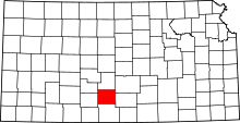 | |
| Unincorporated communities | ||