Byglandsfjorden
| Byglandsfjorden | |
|---|---|
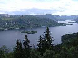 View of Byglandsfjorden | |
| Location |
Bygland and Evje og Hornnes (both in Aust-Agder) |
| Coordinates | 58°42′28″N 7°48′33″E / 58.70778°N 7.80917°E / 58.70778; 7.80917Coordinates: 58°42′28″N 7°48′33″E / 58.70778°N 7.80917°E / 58.70778; 7.80917 |
| Primary inflows | Åraksfjorden |
| Primary outflows | Otra river |
| Catchment area | Otra river |
| Basin countries | Norway |
| Max. length | 34 km (21 mi) |
| Surface area | 32.79 km2 (12.66 sq mi) |
| Shore length1 | 87.57 km (54.41 mi) |
| Surface elevation | 203 m (666 ft) |
| Settlements | Byglandsfjord |
| References | NVE |
| 1 Shore length is not a well-defined measure. | |
Byglandsfjorden is a lake in the municipalities of Bygland and Evje og Hornnes in Aust-Agder county, Norway. It is part of the river Otra, flowing out of the Åraksfjorden. The villages of Byglandsfjord, Lauvdal, and Bygland are all located on the eastern shore of the lake.[1]
The SS Bjoren is a wood-fueled steamboat that travels on the Byglandsfjorden in the summers between the villages of Ose, Bygland, and Byglandsfjord.
A special separate species of salmon occur in Byglandsfjorden, called bleke.
See also
References
- ↑ Store norske leksikon. "Byglandsfjorden" (in Norwegian). Retrieved 2010-04-20.
This article is issued from Wikipedia - version of the 9/4/2015. The text is available under the Creative Commons Attribution/Share Alike but additional terms may apply for the media files.