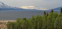
Røssvatnet
| Røssvatnet Reevhtse | |
|---|---|
 | |
| Location | Hattfjelldal, Hemnes, Nordland |
| Coordinates | 65°46′34″N 14°01′57″E / 65.77611°N 14.03250°ECoordinates: 65°46′34″N 14°01′57″E / 65.77611°N 14.03250°E |
| Basin countries | Norway |
| Surface area | 218.61 km2 (84.41 sq mi) |
| Average depth | 67 metres (220 ft)[1] |
| Max. depth |
240 metres (790 ft)[1] (231 m before damming) |
| Water volume |
14.80 km3 (3.55 cu mi)[1] (12.60 km³ before damming) |
| Shore length1 | 256.37 kilometres (159.30 mi) |
| Surface elevation |
383 metres (1,257 ft) (374 m before damming) |
| References | NVE,[1] |
| 1 Shore length is not a well-defined measure. | |
Røssvatnet (Southern Sami: Reevhtse) is a lake and reservoir in the municipalities of Hattfjelldal and Hemnes in Nordland county, Norway. It has been the site of human occupation since the Stone Age. Its area of 219 square kilometres (85 sq mi) makes it the second largest lake in Norway by surface area. Without the dam which has regulated the lake since 1957, it would be 190 square kilometres (73 sq mi) and the third largest lake in Norway. Its depth is 240 metres (790 ft), its volume is estimated at about 15 cubic kilometres (3.6 cu mi), and its surface elevation is 374 metres (1,227 ft) above sea level.[2]
References
- 1 2 3 4 Seppälä, Matti (2005), The Physical Geography of Fennoscandia, Oxford University Press, p. 145, ISBN 978-0-19-924590-1
- ↑ Store norske leksikon. "Røssvatnet" (in Norwegian). Retrieved 2011-11-16.
External links
- Archeological article (in Norwegian) (URL accessed 7 April 1983)
This article is issued from Wikipedia - version of the 9/25/2016. The text is available under the Creative Commons Attribution/Share Alike but additional terms may apply for the media files.