Farris
For other uses, see Farris (disambiguation).
| Farris | |
|---|---|
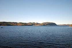 Seen from Gopledal vannverk | |
| Location | Larvik (Vestfold); Siljan, Porsgrunn (Telemark) |
| Coordinates | 59°9′59″N 9°52′36″E / 59.16639°N 9.87667°E / 59.16639; 9.87667Coordinates: 59°9′59″N 9°52′36″E / 59.16639°N 9.87667°E / 59.16639; 9.87667 |
| Type | moraine-dammed lake |
| Basin countries | Norway |
| Surface area | 21.80 km² |
| Shore length1 | 107.07 km |
| Surface elevation | 22 m |
| Islands | Bjørnøya |
| References | NVE |
| 1 Shore length is not a well-defined measure. | |
Farris is a 20 km long fresh water moraine-dammed lake near the Norwegian coastal town Larvik. The lake would have been a salt water fjord had it not been dammed by an end moraine left by the latest ice age. Farris is drinking water reservoir for some 170,000 people. The largest island in the lake is Bjørnøya.
See also
References
This article is issued from Wikipedia - version of the 9/4/2015. The text is available under the Creative Commons Attribution/Share Alike but additional terms may apply for the media files.