Camp Dennison, Ohio
| Camp Dennison, Ohio | |
|---|---|
| Census-designated place | |
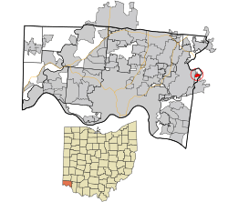 Location in Hamilton County and the state of Ohio. | |
| Coordinates: 39°11′53″N 84°17′19″W / 39.19806°N 84.28861°WCoordinates: 39°11′53″N 84°17′19″W / 39.19806°N 84.28861°W | |
| Country | United States |
| State | Ohio |
| County | Hamilton |
| Area | |
| • Total | 0.4 sq mi (1.0 km2) |
| • Land | 0.4 sq mi (1.0 km2) |
| • Water | 0 sq mi (0 km2) |
| Elevation[1] | 579 ft (176 m) |
| Population (2010) | |
| • Total | 375 |
| • Density | 970/sq mi (380/km2) |
| Time zone | Eastern (EST) (UTC-5) |
| • Summer (DST) | EDT (UTC-4) |
| ZIP code | 45111 |
| FIPS code | 39-11150[2] |
| GNIS feature ID | 1056758[1] |
Camp Dennison is a census-designated place (CDP) just outside Indian Hill in southern Symmes Township, Hamilton County, Ohio, United States. Although it is unincorporated, it has a post office, with the ZIP code of 45111.[3] The population was 375 at the 2010 census.[4] During the American Civil War, Camp Dennison served as a military recruiting and training post for the United States Army (see Camp Dennison). It is named for William Dennison, the 24th Governor of Ohio and U.S. Postmaster General under President Abraham Lincoln.
The community was settled in 1796 by German immigrants.[5]
Geography
Camp Dennison is located at 39°11′53″N 84°17′19″W / 39.19806°N 84.28861°W[6] in the valley of the Little Miami River, 17 miles (27 km) northeast of downtown Cincinnati. Ohio State Route 126, Glendale Milford Road, runs north-south through the center of the community.
According to the United States Census Bureau, the CDP has a total area of 0.39 square miles (1.0 km2), all land.[4]
References
- 1 2 "US Board on Geographic Names". United States Geological Survey. 2007-10-25. Retrieved 2008-01-31.
- ↑ "American FactFinder". United States Census Bureau. Archived from the original on 2013-09-11. Retrieved 2008-01-31.
- ↑ Zip Code Lookup
- 1 2 "Geographic Identifiers: 2010 Demographic Profile Data (G001): Camp Dennison CDP, Ohio". U.S. Census Bureau, American Factfinder. Retrieved November 13, 2012.
- ↑ Bennett, Mary Beth (Nov 2005). "Intersection Camp Dennison". Cincinnati Magazine. p. 42. Retrieved 2013-05-08.
- ↑ "US Gazetteer files: 2010, 2000, and 1990". United States Census Bureau. 2011-02-12. Retrieved 2011-04-23.
Municipalities and communities of Hamilton County, Ohio, United States | ||
|---|---|---|
| Cities |  | |
| Villages | ||
| Townships | ||
| CDPs |
| |
| Other unincorporated communities | ||
| Footnotes | ‡This populated place also has portions in an adjacent county or counties | |