Deer Park, Ohio
| Deer Park, Ohio | |
|---|---|
| City | |
|
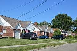
Houses on Orchard Lane | |
| Motto: "Deer Park, The Right Town for a Bright Future" | |
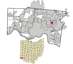 Location in Hamilton County and the state of Ohio. | |
| Coordinates: 39°12′14″N 84°23′48″W / 39.20389°N 84.39667°WCoordinates: 39°12′14″N 84°23′48″W / 39.20389°N 84.39667°W | |
| Country | United States |
| State | Ohio |
| County | Hamilton |
| Government | |
| • Mayor | John Donnellon (R)[1] |
| Area[2] | |
| • Total | 0.87 sq mi (2.25 km2) |
| • Land | 0.87 sq mi (2.25 km2) |
| • Water | 0 sq mi (0 km2) |
| Elevation[3] | 869 ft (265 m) |
| Population (2010)[4] | |
| • Total | 5,736 |
| • Estimate (2012[5]) | 5,704 |
| • Density | 6,593.1/sq mi (2,545.6/km2) |
| Time zone | Eastern (EST) (UTC-5) |
| • Summer (DST) | EDT (UTC-4) |
| ZIP code | 45236 |
| Area code(s) | 513 |
| FIPS code | 39-21266[6] |
| GNIS feature ID | 1048655[3] |
| Website |
www |
Deer Park is a city in Hamilton County, Ohio, United States. The population was 5,736 at the 2010 census.[7]
History
The Cincinnati, Lebanon and Northern Railway began running through the town in 1881, along the "Highland Route".[8] In 1795, following the signing of the Treaty of Greenville which provided assurances to Ohio settlers that they would be protected from Indian "intrusions", Samuel and Rebecca DeMent Pierson established the first log home in the area near Deer Park.
In 1894, Deer Park was described as having one store and a Catholic church.[9]
The community was incorporated in 1912.[10]
Geography
Deer Park is located at 39°12′14″N 84°23′48″W / 39.20389°N 84.39667°W (39.203792, -84.396744).[11]
According to the United States Census Bureau, the city has a total area of 0.87 square miles (2.25 km2), all land.[2]
Demographics
| Historical population | |||
|---|---|---|---|
| Census | Pop. | %± | |
| 1920 | 824 | — | |
| 1930 | 2,642 | 220.6% | |
| 1940 | 3,510 | 32.9% | |
| 1950 | 7,241 | 106.3% | |
| 1960 | 8,423 | 16.3% | |
| 1970 | 7,415 | −12.0% | |
| 1980 | 6,745 | −9.0% | |
| 1990 | 6,181 | −8.4% | |
| 2000 | 5,982 | −3.2% | |
| 2010 | 5,736 | −4.1% | |
| Est. 2015 | 5,682 | [12] | −0.9% |
| Sources:[6][13][14][15][16] | |||
2010 census
As of the census[4] of 2010, there were 5,736 people, 2,618 households, and 1,398 families residing in the city. The population density was 6,593.1 inhabitants per square mile (2,545.6/km2). There were 2,784 housing units at an average density of 3,200.0 per square mile (1,235.5/km2). The racial makeup of the city was 91.9% White, 4.6% African American, 0.1% Native American, 1.3% Asian, 0.6% from other races, and 1.5% from two or more races. Hispanic or Latino of any race were 1.7% of the population.
There were 2,618 households of which 24.7% had children under the age of 18 living with them, 39.1% were married couples living together, 9.9% had a female householder with no husband present, 4.4% had a male householder with no wife present, and 46.6% were non-families. 39.5% of all households were made up of individuals and 13.4% had someone living alone who was 65 years of age or older. The average household size was 2.12 and the average family size was 2.86.
The median age in the city was 38.5 years. 18.8% of residents were under the age of 18; 7.4% were between the ages of 18 and 24; 31.8% were from 25 to 44; 26.1% were from 45 to 64; and 15.8% were 65 years of age or older. The gender makeup of the city was 47.4% male and 52.6% female.
2000 census
As of the census[6] of 2000, there were 5,982 people, 2,634 households, and 1,496 families residing in the city. The population density was 6,979.0 people per square mile (2,685.7/km²). There were 2,723 housing units at an average density of 3,176.8 per square mile (1,222.5/km²). The racial makeup of the city was 96.52% White, 1.69% African American, 0.18% Native American, 0.69% Asian, 0.22% from other races, and 0.70% from two or more races. Hispanic or Latino of any race were 0.67% of the population.
There were 2,634 households out of which 25.7% had children under the age of 18 living with them, 43.0% were married couples living together, 9.8% had a female householder with no husband present, and 43.2% were non-families. 39.1% of all households were made up of individuals and 16.5% had someone living alone who was 65 years of age or older. The average household size was 2.18 and the average family size was 2.94.
In the city the population was spread out with 21.8% under the age of 18, 6.3% from 18 to 24, 32.7% from 25 to 44, 18.9% from 45 to 64, and 20.3% who were 65 years of age or older. The median age was 38 years. For every 100 females there were 86.1 males. For every 100 females age 18 and over, there were 79.8 males.
The median income for a household in the city was $39,692, and the median income for a family was $45,585. Males had a median income of $36,753 versus $28,706 for females. The per capita income for the city was $22,274. About 3.7% of families and 5.3% of the population were below the poverty line, including 4.8% of those under age 18 and 10.8% of those age 65 or over.
Education
Deer Park Junior/Senior High School is the secondary school of Deer Park.
Notable person
- Bill Cunningham, conservative radio personality
References
- ↑ "Hamilton County Officials 2016" (PDF). Hamilton County Board of Elections. 27 January 2016. Retrieved 1 February 2016.
- 1 2 "US Gazetteer files 2010". United States Census Bureau. Retrieved 2013-01-06.
- 1 2 "US Board on Geographic Names". United States Geological Survey. 2007-10-25. Retrieved 2008-01-31.
- 1 2 "American FactFinder". United States Census Bureau. Retrieved 2013-01-06.
- ↑ "Population Estimates". United States Census Bureau. Retrieved 2013-06-17.
- 1 2 3 "American FactFinder". United States Census Bureau. Retrieved 2008-01-31.
- ↑ "Profile of General Population and Housing Characteristics: 2010 Demographic Profile Data (DP-1): Deer Park city, Ohio". U.S. Census Bureau, American Factfinder. Retrieved October 30, 2012.
- ↑ "Deer Park Ohio Historypublisher= City of Deer Park Ohio". Retrieved 2012-07-15.
- ↑ Nelson, S. B. (1894). History of Cincinnati and Hamilton County, Ohio: Their Past and Present, Including...biographies and Portraits of Pioneers and Representative Citizens, etc., Volume 1. p. 453. Retrieved 11 December 2013.
- ↑ "City of Deer Park, Ohio History, Information and Statistics". City of Deer Park, Ohio. Retrieved July 19, 2012.
- ↑ "US Gazetteer files: 2010, 2000, and 1990". United States Census Bureau. 2011-02-12. Retrieved 2011-04-23.
- ↑ "Annual Estimates of the Resident Population for Incorporated Places: April 1, 2010 to July 1, 2015". Retrieved July 2, 2016.
- ↑ "Population: Ohio" (PDF). 1930 US Census. U.S. Census Bureau. Retrieved 28 November 2013.
- ↑ "Number of Inhabitants: Ohio" (PDF). 18th Census of the United States. U.S. Census Bureau. Retrieved 22 November 2013.
- ↑ "Ohio: Population and Housing Unit Counts" (PDF). U.S. Census Bureau. Retrieved 22 November 2013.
- ↑ "Incorporated Places and Minor Civil Divisions Datasets: Subcounty Population Estimates: April 1, 2010 to July 1, 2012". U.S. Census Bureau. Retrieved 25 November 2013.
External links
Municipalities and communities of Hamilton County, Ohio, United States | ||
|---|---|---|
| Cities |  | |
| Villages | ||
| Townships | ||
| CDPs |
| |
| Other unincorporated communities | ||
| Footnotes | ‡This populated place also has portions in an adjacent county or counties | |