Casa de Contratación
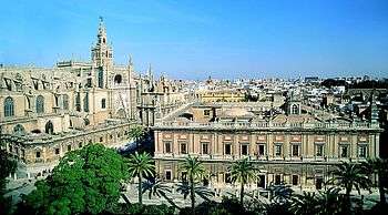
The Casa de Contratación (Spanish pronunciation: [ˈkasa ðe kontɾataˈθjon], "House of Trade") was a government agency of the Spanish Empire, existing from the 16th to the 18th centuries, which attempted to control all Spanish exploration and colonization. Its official name was La Casa y Audiencia de Indias; it was established in the port city of Seville, Castile (Corona de Castilla).[1]
Introduction
Unlike the later East India Companies, chartered companies established by the Dutch, English, and others, the Casa collected all colonial taxes and duties, approved all voyages of exploration and trade, maintained secret information on trade routes and new discoveries,[2][3] licensed captains, and administered commercial law. In theory, no Spaniard could sail anywhere without the approval of the Casa. However, smuggling often took place in different parts of the vast Spanish Empire.[4][5][6]
The Casa de Contratación was founded by Queen Isabella I of Castile in 1503, eleven years after the discovery of the Americas in 1492.[7] The Casa was the Spanish counterpart of the Portuguese organization, the Casa da Índia, or House of Índia of Lisbon,[8][9] established in 1434 and destroyed in 1755 by the Lisbon earthquake.
Operation
A 20 per cent tax, the Quinto Real (Royal Fifth) was levied by the Casa on all precious metals entering Spain.[10][11] The other taxes could run as high as 40% to provide naval protection for the trading ships or as low as 10 per cent during financial turmoil to encourage investment and economic growth in the colony. Each ship was required to employ a clerk to keep detailed logs of all goods carried and all transactions.[12]
The Casa de Contratación produced and managed the Padrón Real, the official and secret Spanish map used as a template for the maps carried by every Spanish ship during the 16th century.[13] It was constantly improved from its first version in 1508, and was the counterpart of the Portuguese map, the Padrão Real. The Casa also ran a navigation school; new pilots, or navigators, were trained for ocean voyages here.[14]
Spain employed the then standard mercantilist model, governed (at least in theory) by the Casa in Seville. Trade with the overseas possessions was handled by a merchants' guild based in Seville, the Consulado de mercaderes, which worked in conjunction with the Casa de Contratación. Trade was physically controlled in well-regulated trade fleets, the famous Flota de Indias and the Manila galleons.
Reductions
By the late 17th century, the Casa de Contratación had fallen into bureaucratic gridlock, and the empire as a whole was failing, due primarily to Spain's inability to finance both war on the Continent and a global empire. More often than not, the riches transported from Manila and Acapulco to Spain were officially signed over to Spain's creditors before the Manila galleon made port. In the 18th century, the new Bourbon kings reduced the power of Seville and the Casa de Contratacion.[15] In 1717 they moved the Casa from Seville to Cádiz, diminishing Seville's importance in international trade. Charles III further limited the powers of the Casa,[16] and his son, Charles IV, abolished it altogether in 1790.[16][17]
Mapmakers
The mapmaking enterprise at the Casa de Contratación was a huge undertaking, and critical to the success of the voyages of discovery. Without good navigational aids, the ability of Spain to exploit and profit from its discoveries would have been limited. The Casa had a large number of cartographers and navigators (pilots), archivists, record keepers, administrators and others involved in producing and managing the Padrón Real.[18]
The famous explorer Amerigo Vespucci, who made at least two voyages to the New World, was a pilot working at the Casa de Contratación until his death in 1512.[19] A special position was created for Vespucci, the piloto mayor (chief of navigation), in 1508;[20] he trained new pilots for ocean voyages.[12] His nephew Juan Vespucci inherited his famous uncle's maps, charts, and nautical instruments,[21] and along with Andrés de San Martín was appointed to Amerigo's former position as the official Spanish government pilot at Seville.[22][23] In 1524, Juan Vespucci was appointed examinador de pilotos (Examiner of Pilots),[24] replacing Sebastian Cabot who was then leading an expedition in Brazil.[25][26]
In the 1530s and 1540s, the principal mapmakers (known as "cosmographers") in the Casa de Contratación working on the Padrón Real included Alonso de Santa Cruz,[27] Sebastian Cabot, and Pedro de Medina.[28] The mapmaker Diego Gutiérrez was appointed as cosmographer in the Casa on October 22, 1554, after the death of his father Diego in January 1554; he also worked on the Padrón Real. In 1562 Gutierrez published the map entitled "Americae...Descriptio" in Antwerp. It was published in Antwerp instead of Spain because the Spanish engravers did not have the necessary skill to print such a complicated document.[29] Other cosmographers included Alonso de Chaves, Francisco Falero, Jerónimo de Chaves, Sancho Gutiérrez (Diego's brother).[30][31]
In the late 16th century, Juan Lopez de Velasco was the first Cosmógrafo-Cronista Mayor (Cosmographer-Chronicler Major) of the Council of the Indies in Seville.[32] He produced a master map and twelve subsidiary maps portraying the worldwide Spanish empire in cartographic form.[33][34][35] Although these maps are not especially accurate or detailed, his work represented the apogee of Spanish mapmaking in that period, and surpassed anything done by the other European powers. Cartographers in England, the Low Countries, and Germany, however, continued to improve their skills in making maps and in organizing and presenting geographic information, until by the end of the 17th century, even Spanish intellectuals were lamenting that the maps produced by foreigners were superior to those made in Spain.[36][37][38]
See also
- The Virgin of the Navigators - First painting depicting the discovery of the Americas. In a chapel at the Casa de Contratación.
References
- ↑ Jorge Galván (2006). El hierro y la pólvora. UNAM. p. 231. ISBN 978-970-770-393-3.
- ↑ Richard Flint; Shirley Cushing Flint (18 March 2003). The Coronado Expedition: From the Distance of 460 Years. UNM Press. p. 265. ISBN 978-0-8263-2977-6.
- ↑ James D. Henderson; Helen Delpar; Maurice Philip Brungardt; Richard N. Weldon (2000). A Reference Guide to Latin American History. M.E. Sharpe. p. 26. ISBN 978-1-56324-744-6.
- ↑ Jean O. McLachlan (19 November 2015). Trade and Peace with Old Spain, 1667–1750. Cambridge University Press. p. 80. ISBN 978-1-107-58561-4.
- ↑ William S. Maltby (24 November 2008). The Rise and Fall of the Spanish Empire. Palgrave Macmillan. p. 81. ISBN 978-1-137-04187-6.
- ↑ J. A. C. Hugill (1991). No Peace Without Spain. Kensal Press. p. 19. ISBN 978-0-946041-58-9.
- ↑ John Michael Francis (2006). Iberia and the Americas: Culture, Politics, and History : a Multidisciplinary Encyclopedia. ABC-CLIO. p. 179. ISBN 978-1-85109-421-9.
- ↑ Susannah Ferreira (29 May 2015). The Crown, the Court and the Casa da Índia: Political Centralization in Portugal 1479-1521. BRILL. p. 169. ISBN 978-90-04-29819-4.
- ↑ Hans Ferdinand Helmolt (1901). Pre-history. America and the Pacific ocean. W. Heinemann. p. 388.
- ↑ Massimo Livi-Bacci (2008). Conquest: The Destruction of the American Indios. Polity. p. 293. ISBN 978-0-7456-4001-3.
- ↑ José de Acosta (24 September 2002). Natural and Moral History of the Indies. Duke University Press. p. 177. ISBN 0-8223-8393-4.
- 1 2 Patrick O'Flanagan (28 June 2013). Port Cities of Atlantic Iberia, c. 1500–1900. Ashgate Publishing, Ltd. p. 46. ISBN 978-1-4094-8011-2.
- ↑ David Waters (1970). The Iberian Bases of the English Art of Navigation in the Sixteenth Century. UC Biblioteca Geral 1. p. 13. GGKEY:KXSJC7ZAS51.
- ↑ Benjamin Keen; Keith A. Haynes (1 July 2008). A History of Latin America, Volume 1: Ancient America to 1910: Ancient America to 1910. Cengage Learning. p. 91. ISBN 0-618-78320-2.
- ↑ Richard Harding (4 January 2002). Seapower and Naval Warfare, 1650-1830. Routledge. p. 24. ISBN 978-1-135-36486-1.
- 1 2 Max Beloff (19 December 2013). The Age of Absolutism (Routledge Revivals): 1660-1815. Taylor & Francis. p. 51. ISBN 978-1-317-81664-5.
- ↑ Albert Goodwin (23 September 1976). The New Cambridge Modern History: Volume 8, The American and French Revolutions, 1763-93. CUP Archive. p. 402. ISBN 978-0-521-29108-8.
- ↑ Lloyd Arnold Brown (1979). The Story of Maps. Courier Corporation. p. 143. ISBN 978-0-486-23873-9.
- ↑ Elizabeth Nash (13 October 2005). Seville, Cordoba, and Granada: A Cultural History. Oxford University Press, USA. p. 84. ISBN 978-0-19-518204-0.
- ↑ Frederick Julius Pohl (28 October 2013). Amerigo Vespucci: Pilot Major. Routledge. p. 187. ISBN 978-1-136-22713-4.
- ↑ Frederick Albion Ober (1907). Amerigo Vespucci. Harper & Brothers. pp. 235–236.
- ↑ Clarence Henry Haring (1918). Trade and Navigation Between Spain and the Indies in the Time of the Hapsburgs. Harvard University Press. p. 307.
- ↑ Manuel de la Puente y Olea (1900). Los trabajos geográficos de la Casa de Contratación. Escuela Tipográfica y Librería Salesianas. p. 283.
- ↑ Álvarez Massini Álvarez; José María Olivero; Olivero Orecchia Olivero; Enrique Carlos Albornoz Nessi Albornoz (2007). Cartografía y navegación: del portulano a la carta esférica : del siglo XIII a comienzos del siglo XIX. Armada Nacional. p. 275. ISBN 978-9974-7624-1-1.
- ↑ William Patterson Cumming; Louis De Vorsey (1998). The Southeast in early maps. University of North Carolina Press. p. 4.
- ↑ The Geographical Journal. Royal Geographical Society. 1915. p. 83.
- ↑ Richard L. Kagan; Fernando Marías (2000). Urban Images of the Hispanic World, 1493-1793. Yale University Press. p. 55. ISBN 978-0-300-08314-9.
- ↑ Pamela Smith; Paula Findlen (18 October 2013). Merchants and Marvels: Commerce, Science, and Art in Early Modern Europe. Taylor & Francis. p. 91. ISBN 978-1-135-30035-7.
- ↑ Encounters. Latin American Institute of the University of New Mexico. 1989. p. 16.
- ↑ Aaron M. Kahn (22 September 2011). On Wolves and Sheep: Exploring the Expression of Political Thought in Golden Age Spain. Cambridge Scholars Publishing. p. 219. ISBN 978-1-4438-3417-9.
- ↑ Pedro Ruiz-Castell and Ximo Guillem-Llobat; Josep Simon; Néstor Herran with Tayra Lanuza-Navarro (27 May 2009). Beyond Borders: Fresh Perspectives in History of Science. Cambridge Scholars Publishing. p. 83. ISBN 978-1-4438-1147-7.
- ↑ Daniela Bleichmar (18 December 2008). Science in the Spanish and Portuguese Empires, 1500–1800. Stanford University Press. p. 70. ISBN 978-0-8047-7633-2.
- ↑ David Woodward (1 September 2007). Cartography in the European Renaissance. University of Chicago Press. p. 1146. ISBN 978-0-226-90733-8.
- ↑ David Buisseret (22 May 2003). The Mapmakers' Quest: Depicting New Worlds in Renaissance Europe. Oxford University Press. p. 89. ISBN 978-0-19-150090-9.
- ↑ Barbara E. Mundy (1 December 2000). The Mapping of New Spain: Indigenous Cartography and the Maps of the Relaciones Geograficas. University of Chicago Press. pp. 17–18, 22–23. ISBN 978-0-226-55097-8.
- ↑ Martin Jay; Sumathi Ramaswamy (29 January 2014). Empires of Vision: A Reader. Duke University Press. pp. 215–216. ISBN 978-0-8223-7897-6.
- ↑ Evonne Levy; Kenneth Mills (6 January 2014). Lexikon of the Hispanic Baroque: Transatlantic Exchange and Transformation. University of Texas Press. p. 26. ISBN 978-0-292-75309-9.
- ↑ David Buisseret (6 July 1998). Envisioning the City: Six Studies in Urban Cartography. University of Chicago Press. p. 101. ISBN 978-0-226-07993-6.
Further reading
- McDougall, Walter (1993): Let the Sea Make a Noise: Four Hundred Years of Cataclysm, Conquest, War and Folly in the North Pacific. Avon Books, New York, USA.
- Spain Maps Her "New World", David Buisseret, "Encounters", February 1992, No. 8, pp. 14–19.
- Barrera Osorio, Antonio, Experiencing Nature: The Spanish American Empire and the Early Scientific Revolution (Austin: University of Texas Press, 2006).