Felipe González de Ahedo
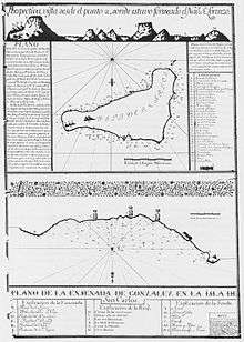
The map of Easter Island (renamed "Isla de San Carlos") from González de Ahedo's 1770 expedition. North is down.
Felipe González de Ahedo, also spelled Phelipe González y Haedo (1702, in Santoña, Cantabria – 1792), was a Spanish navigator and cartographer known for annexing Easter Island in 1770.
González de Ahedo commanded two Spanish ships, the San Lorenzo and the Santa Rosalia, sent by the Viceroy of Peru, Manuel de Amat y Juniet. They landed on 1770 November 15, only the second time European had seen Easter Island, and stayed five days, thoroughly surveyed the coast, and named it Isla de San Carlos, taking possession on behalf of King Charles III of Spain. They ceremoniously signed a treaty of annexation with the inhabitants and erected three wooden crosses on top of three small hills on Poike volcano.[1] They reported the island as largely uncultivated, with a seashore lined with stone statues.
References
- ↑ Jo Anne Van Tilburg. Easter Island: Archaeology, Ecology and Culture. British Museum Press, London, 1994. ISBN 0-7141-2504-0
|
|---|
|
| Timeline | |
|---|
|
| Territories |
- Southern Italy and Sicily
- Naples
- Union with Holy Roman Empire
- Milan
- Netherlands
- Franche-Comté
- Portugal
- Philippines
- East Pacific (Guam, Mariana, Caroline, Palau, Marshall, Micronesia, Moluccas)
- Northern Taiwan
- Tidore
- Florida
- New Spain (Western United States, Mexico, Central America, Spanish Carribean)
- Spanish Louisiana
- Coastal Alaska
- Haiti
- Belize
- Jamaica
- Trinidad and Tobago
- Venezuela, Northern and Western Guyana
- New Granada (Panama, Colombia, Ecuador, a northernmost portion of Brazilian Amazon)
- Peru (Peru, Acre)
- Río de la Plata (Argentina, Paraguay, Upper Peru (Bolivia), Banda Oriental (Uruguay), Falkland Islands)
- Chile
- Equatorial Guinea
- Spanish North Africa (Ifni, Cape Juby, Spanish Morocco and Western Sahara)
|
|---|
|
| Administration | |
|---|
|
Administrative
subdivisions | |
|---|
|
| Economy | |
|---|
|
| Military | |
|---|
|
Won Old World
great battles | |
|---|
|
Lost Old World
great battles | |
|---|
|
Won New World
great battles | |
|---|
|
Lost New World
great battles | |
|---|
|
Spanish
colonizations | |
|---|
|
Other
civil topics | |
|---|