Castelmagno
| Castelmagno | ||
|---|---|---|
| Comune | ||
| Comune di Castelmagno | ||
|
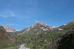
Castelmagno: at right the Santuario di San Magno (Saint Magnus's sanctuary), on background at center the Reina peak and at his feet the Grana valley | ||
| ||
 Castelmagno Location of Castelmagno in Italy | ||
| Coordinates: 44°25′N 7°13′E / 44.417°N 7.217°ECoordinates: 44°25′N 7°13′E / 44.417°N 7.217°E | ||
| Country | Italy | |
| Region | Piedmont | |
| Province / Metropolitan city | Cuneo (CN) | |
| Frazioni | Campomolino, Chiappi, Chiotti, Colletto, Einaudi, Nerone | |
| Government | ||
| • Mayor | Maurizio Giaminardi | |
| Area | ||
| • Total | 48.8 km2 (18.8 sq mi) | |
| Elevation | 1,150 m (3,770 ft) | |
| Population (31 August 2007)[1] | ||
| • Total | 95 | |
| • Density | 1.9/km2 (5.0/sq mi) | |
| Demonym(s) | Castelmagnesi | |
| Time zone | CET (UTC+1) | |
| • Summer (DST) | CEST (UTC+2) | |
| Postal code | 12020 | |
| Dialing code | 0171 | |
| Patron saint | St. Magnus | |
| Saint day | August 19 | |
| Website | Official website | |

Castelmagno is a small comune (municipality) in the Province of Cuneo in the Italian region of Piedmont, located about 80 kilometres (50 mi) southwest of Turin and about 25 kilometres (16 mi) west of Cuneo.
The population of the municipality of Castelmagno is divided between the frazioni (hamlets) of Einaudi, Campomolino, Colletto, Nerone, Chiotti and Chiappi; "Castelmagno" is the name of the municipal entity, not corresponding to any hamlet. The main attraction is the sanctuary of San Magno, at an elevation of 1,761 metres (5,778 ft) above sea level.
Castelmagno borders the following municipalities: Celle di Macra, Demonte, Dronero, Marmora, Monterosso Grana, Pradleves, and San Damiano Macra.
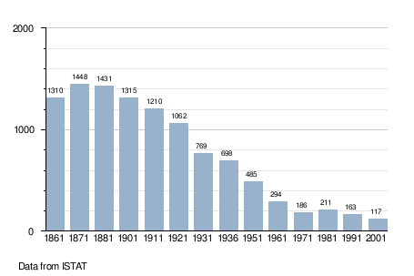
Demographic evolution
Twin towns — Sister cities
Castelmagno is twinned with:
-
 Quittengo, Italy (1975)