Trezzo Tinella
| Trezzo Tinella Trés | |
|---|---|
| Comune | |
| Comune di Trezzo Tinella | |
 | |
 Trezzo Tinella Location of Trezzo Tinella in Italy | |
| Coordinates: 44°41′N 8°6′E / 44.683°N 8.100°ECoordinates: 44°41′N 8°6′E / 44.683°N 8.100°E | |
| Country | Italy |
| Region | Piedmont |
| Province / Metropolitan city | Province of Cuneo (CN) |
| Frazioni | Cappelletto, Mompiano, Leomonte |
| Government | |
| • Mayor | VIAZZI Mario |
| Area | |
| • Total | 10.4 km2 (4.0 sq mi) |
| Elevation | 341 m (1,119 ft) |
| Population (Dec. 2008) | |
| • Total | 350 |
| • Density | 34/km2 (87/sq mi) |
| Time zone | CET (UTC+1) |
| • Summer (DST) | CEST (UTC+2) |
| Postal code | 12050 |
| Dialing code | 0173 |
| Patron saint | Sant'Antonio Abate |
| Website | Official website |
Trezzo Tinella is a comune (municipality) in the Province of Cuneo in the Italian region Piedmont, located about 50 kilometres (31 mi) southeast of Turin and about 50 kilometres northeast of Cuneo. As of 31 December 2004, it had a population of 350 and an area of 10.4 square kilometres (4.0 sq mi).[1]
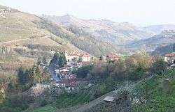
The small and affable commune of Trezzo Tinella is located high in the Langa region. It occupies a very large territory situated at different elevations from 304 to 712 metres (997 to 2,336 ft) above sea level. At the centre of the commune is a church and the town hall. There was once a castle, the final tower of the castle collapsed in 1969. There was also a nursery and school which was closed in 1986. Trezzo Tinella has dairy farms, vineyards, hazelnut groves and houses. A number of the buildings date back to Roman Times and the names derive from this era.
Trezzo Tinella borders the following municipalities: Alba, Borgomale, Castino, Mango, Neviglie, and Treiso.
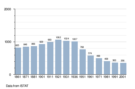
Demographic evolution