Alto, Piedmont
| Alto | ||
|---|---|---|
| Comune | ||
| Comune di Alto | ||
| ||
 Alto Location of Alto in Italy | ||
| Coordinates: 44°7′N 8°0′E / 44.117°N 8.000°ECoordinates: 44°7′N 8°0′E / 44.117°N 8.000°E | ||
| Country | Italy | |
| Region | Piedmont | |
| Province / Metropolitan city | Province of Cuneo (CN) | |
| Government | ||
| • Mayor |
Francesco De Andreis (elected 2004-06-13) | |
| Area | ||
| • Total | 7.6 km2 (2.9 sq mi) | |
| Elevation | 650 m (2,130 ft) | |
| Population (Dec. 2004) | ||
| • Total | 113 | |
| • Density | 15/km2 (39/sq mi) | |
| Demonym(s) | Altesi | |
| Time zone | CET (UTC+1) | |
| • Summer (DST) | CEST (UTC+2) | |
| Postal code | 12070 | |
| Dialing code | 0174 | |
| Patron saint | Michael the Archangel | |
| Saint day | 29 September | |
Alto is a comune (municipality) in the Province of Cuneo in the Italian region Piedmont, located about 110 kilometres (68 mi) south of Turin and about 45 kilometres (28 mi) southeast of Cuneo. As of 31 December 2004, it had a population of 113 and an area of 7.6 square kilometres (2.9 sq mi).[1]
Alto borders the following municipalities: Aquila di Arroscia, Caprauna, Nasino, and Ormea.
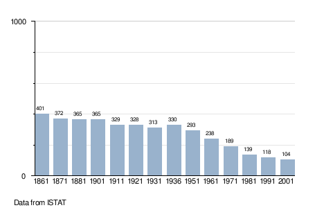
Demographic evolution
References
This article is issued from Wikipedia - version of the 1/31/2015. The text is available under the Creative Commons Attribution/Share Alike but additional terms may apply for the media files.