Dronero
| Dronero | ||
|---|---|---|
| Comune | ||
| Comune di Dronero | ||
|
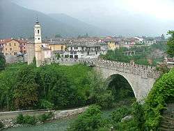
A view of Dronero | ||
| ||
 Dronero Location of Dronero in Italy | ||
| Coordinates: 44°28′N 7°22′E / 44.467°N 7.367°E | ||
| Country | Italy | |
| Region | Piedmont | |
| Province / Metropolitan city | Cuneo (CN) | |
| Frazioni | AArchero, Borgata Lerda, Borgata Nuova, Borgetto, Fornace, Gangotta Sottana, Lerda, Madonna Addolorata, Monastero, Murassone Nasani, Perotti, Ponte di Bedale, Pratavecchia, Ripoli, Ruà del Prato, San Maurizio, Santa Lucia, Sant'Anna di Piossasco, Tetti | |
| Government | ||
| • Mayor | Livio Acchiardi | |
| Area | ||
| • Total | 58.9 km2 (22.7 sq mi) | |
| Elevation | 622 m (2,041 ft) | |
| Population (31 December 2010)[1] | ||
| • Total | 7,317 | |
| • Density | 120/km2 (320/sq mi) | |
| Demonym(s) | Droneresi | |
| Time zone | CET (UTC+1) | |
| • Summer (DST) | CEST (UTC+2) | |
| Postal code | 12025 | |
| Dialing code | 0171 | |
| Patron saint | Madonna di Ripoli | |
| Saint day | Second Sunday in September | |
| Website | Official website | |

Dronero (Occitan: Draonier) is a comune (municipality) in the Province of Cuneo in the Italian region Piedmont, located about 70 kilometres (43 mi) southwest of Turin and about 15 kilometres (9 mi) northwest of Cuneo at the entrance of the Valle Maira.
Typical things
- Ponte Vecchio, also known as Ponte del Diavolo ("Devil's Bridge")
- Torrazza, a watch tower
- Droneresi al Rum, a typical delicious sweet, made of two meringues and a heart of chocolate, rum and custard. You can find them near San Sebastian square, in the center of Dronero.
References
External links
This article is issued from Wikipedia - version of the 4/23/2015. The text is available under the Creative Commons Attribution/Share Alike but additional terms may apply for the media files.