Castleberry–Harrington Historic District
|
Castleberry–Harrington Historic District | |
 | |
  | |
| Location | Castleberry Rd., Republican, Arkansas |
|---|---|
| Coordinates | 35°15′36″N 92°25′36″W / 35.26000°N 92.42667°WCoordinates: 35°15′36″N 92°25′36″W / 35.26000°N 92.42667°W |
| Area | 1.5 acres (0.61 ha) |
| Built | 1946 |
| Architectural style | Mixed Masonry |
| MPS | Mixed Masonry Buildings of Silas Owens Sr. MPS |
| NRHP Reference # | 07000503[1] |
| Added to NRHP | June 5, 2007 |
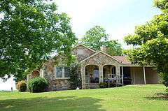
The Castleberry–Harrington Historic District encompasses a collection of three mixed masonry buildings erected between 1946 and 1950 by regionally known master mason Silas Owens Sr. on Castleberry Road in rural northwestern Faulkner County, Arkansas. All are single story stone structures, built of various shades of sandstone and other materials, and were built for various members of the extended Castleberry and Harrington families. One of them has an applied herringbone pattern of stonework for which Owens was particularly well known. The three houses are located on Castleberry Road, south of the hamlet of Republican.[2]
The district was listed on the National Register of Historic Places in 2007.[1]
See also
References
- 1 2 National Park Service (2010-07-09). "National Register Information System". National Register of Historic Places. National Park Service.
- ↑ "NRHP nomination for Castleberry–Harrington Historic District" (PDF). Arkansas Preservation. Retrieved 2016-02-09.
| Topics | |
|---|---|
| Lists by states |
|
| Lists by insular areas | |
| Lists by associated states | |
| Other areas | |
| |
This article is issued from Wikipedia - version of the 12/2/2016. The text is available under the Creative Commons Attribution/Share Alike but additional terms may apply for the media files.