Catherineberg Sugar Mill Ruins
|
Catherineberg-Jockumsdahl-Herman Farm | |
|
Catherineberg Sugar Mill Ruins; | |
| Nearest city | Cruz Bay, U.S. Virgin Islands |
|---|---|
| Coordinates | 18°20′48″N 64°45′41″W / 18.34667°N 64.76139°WCoordinates: 18°20′48″N 64°45′41″W / 18.34667°N 64.76139°W |
| MPS | Virgin Islands National Park MRA (AD) |
| NRHP Reference # | 78000270[1] |
| Added to NRHP | March 30, 1978 |
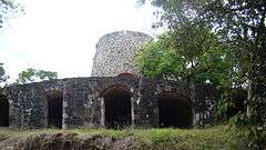
Catherineberg Sugar Mill Ruins is an historic site located in the Virgin Islands National Park, east of Cruz Bay on Saint John, U.S. Virgin Islands. The ruins are an example of an 18th-century sugar and rum factory.
To reach Catherineberg, turn north on John Head Road from Centerline Road. There is room for several cars to park right next to the windmill.
History
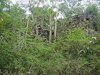
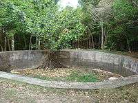
A sugar plantation from the 18th to the 19th centuries, the farm eventually became land for grazing cattle.
In 1733 one of the first significant slave rebellions in the New World took place on Saint John when African slaves took over the island for six months. During the slave revolt, the farm was the headquarters of the Amina warriors.
Today the sugar mill ruins are located in a protected area in the Virgin Islands National Park. The property was added to the U.S. National Register of Historic Places on March 30, 1978.
Architecture

Catherineberg Sugar Mill Ruins are an example of an 18th-century sugar and rum factory.
See also
- Estate Catherineberg
- Sugar production in the Danish West Indies
- Danish West Indies topics
References
- ↑ National Park Service (2008-04-15). "National Register Information System". National Register of Historic Places. National Park Service.
External links
| Wikimedia Commons has media related to Catherineberg Sugar Mill Ruins. |
- National Park Service: Catherineberg-Jockumsdahl-Herman Farm webpage.
-
 Media related to Plantations in the United States Virgin Islands at Wikimedia Commons
| Topics | |
|---|---|
| Lists by states |
|
| Lists by insular areas | |
| Lists by associated states | |
| Other areas | |
| |