Cato Hill Historic District
|
Cato Hill Historic District | |
|
Clarkin Lane | |
  | |
| Location | Woonsocket, Rhode Island |
|---|---|
| Architect | Unknown |
| Architectural style | Greek Revival, Queen Anne, Federal |
| MPS | Woonsocket MRA (AD) |
| NRHP Reference # | 76002255 [1] |
| Added to NRHP | August 10, 1976 |
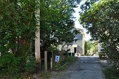
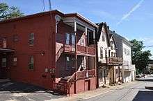
The Cato Hill Historic District is a residential historic district (United States) in central Woonsocket, Rhode Island. It consists of about 2-1/2 blocks of Church and Cato Streets, as well as the streets crossing them (Clarkin Lane and Boyden Street). The area, located on a hill just above Woonsocket's downtown area, is a densely populated area built primarily between 1838 and 1875, during Woonsocket's growth as a major textile processing center. Cato Hill is named for Cato Aldrich, an African American who purchased the land from the Arnolds who founded Woonsocket. The houses of the district exhibit vernacular forms of the architectural styles popular in the mid-19th century.[2]
The district was listed on the National Register of Historic Places in 1976.[1]
See also
References
- 1 2 National Park Service (2007-01-23). "National Register Information System". National Register of Historic Places. National Park Service.
- ↑ "NRHP nomination for Cato Hill Historic District" (PDF). Rhode Island Preservation. Retrieved 2014-08-05.
| Topics | |
|---|---|
| Lists by states |
|
| Lists by insular areas | |
| Lists by associated states | |
| Other areas | |
| |
Coordinates: 42°00′21″N 71°30′58″W / 42.00583°N 71.51611°W