Gander, Newfoundland and Labrador
| Gander | |||
|---|---|---|---|
| Town | |||
| |||
|
Motto: "Volet Gander" (Latin) "May Gander soar" | |||
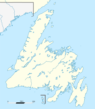 Gander Location of Gander in Newfoundland | |||
| Coordinates: 48°57′25″N 54°36′32″W / 48.95694°N 54.60889°W | |||
| Country |
| ||
| Province |
| ||
| Census division | Division No. 6, Newfoundland and Labrador | ||
| Settled | 1936 | ||
| Incorporated | 1958 | ||
| Government | |||
| • Type | Gander Town Council | ||
| • Mayor | Phil Dooley | ||
| Area | |||
| • Total | 104.25 km2 (40.25 sq mi) | ||
| Elevation | 128 m (420 ft) | ||
| Population (2011)[1] | |||
| • Total | 11,054 | ||
| • Density | 106.0/km2 (275/sq mi) | ||
| Time zone | Newfoundland Time (UTC-3:30) | ||
| • Summer (DST) | Newfoundland Daylight (UTC-2:30) | ||
| Postal code span | A1V | ||
| Area code(s) | 709 | ||
| Highways | Route 1, Route 330 | ||
| Website | Town of Gander (official site) | ||


Gander is a Canadian town located in the northeastern part of the island of Newfoundland in the province of Newfoundland and Labrador, approximately 40 kilometres (25 mi) south of Gander Bay, 100 km (62 mi) south of Twillingate and 90 km (56 mi) east of Grand Falls-Windsor. Located on the northeastern shore of Gander Lake, it is the site of Gander International Airport, formerly an important refuelling point for Transatlantic aircraft, and presently a preferred stopping point for transatlantic aircraft that need to land because of on-board medical or security emergencies.
Most of the streets in Gander are named after famous aviators, including Amelia Earhart, Alcock and Brown, Charles Lindbergh, Eddie Rickenbacker, Marc Garneau and Chuck Yeager.[2]
History
Gander was chosen for the construction of an airport in 1935 because of its location close to the northeast tip of the North American continent. In 1936, construction of the base began, and the town started to develop. On January 11, 1938, Captain Douglas Fraser made the first landing at "Newfoundland Airport", now known as Gander International Airport, or "CYQX", in a single-engine biplane, Fox Moth VO-ADE.
During the Second World War, as many as 10,000 Canadian, British and American military personnel resided in Gander. The area became a strategic post for the Royal Air Force Air Ferry Command, with approximately 20,000 American- and Canadian-built fighters and bombers stopping at Gander en route to Europe. After the war, the airbase became a civilian airport, and the location of the town was moved a safe distance from the runways. Construction of the present town site began in the 1950s, and the present municipality was incorporated in 1958; the settlement around the airport was eventually abandoned.[3]
After the Second World War, the town grew as the airport was used as a refuelling stop for transatlantic flights, earning its name "Cross-roads of the world". Efforts have been made to diversify the economy from being dependent on the airport, particularly as new aircraft designs permitted longer-range flights without the need for landing to refuel.
Gander was the site of a major aircraft accident, Arrow Air Flight 1285, on December 12, 1985. 256 people were killed in the disaster, making it the deadliest air crash to happen in Canada.
In 2001, Gander International Airport played an integral role in world aviation in the hours immediately following the September 11 attacks when all of North America's airspace was closed by Transport Canada and the United States Federal Aviation Administration (FAA). As part of Operation Yellow Ribbon, 38 civilian and 4 military flights bound for the United States were ordered to land at the airport—more flights than any Canadian airport other than Halifax International. More than 6,600 passengers and airline crew members, equivalent to 66 percent of the local population—third highest number of passengers, behind Vancouver International, which received 8,500, and Halifax—found themselves forced to stay in the Gander area for up to six days until airspace was reopened and flights resumed. Residents of Gander and surrounding communities volunteered to house, feed, and entertain the travellers in what became known as Operation Yellow Ribbon. This was largely because Transport Canada and Nav Canada asked that transatlantic flights avoid major airports in central Canada, such as Toronto Pearson International Airport and Montréal-Dorval.
Lufthansa named one of its Airbus A340 aircraft Gander/Halifax to thank both cities for their handling of rerouted travellers on September 11. In addition, a book called The Day The World Came to Town was published by Reagan Books, and several stories and segments about Gander's role during that and subsequent days have been featured on various educational and news programs. A radio play, The Day the Planes Came by Caroline and David Stafford, dealt with the effect on Gander of the September 11 passengers. The play was first broadcast in June 2008 on BBC Radio 4, and was repeated in October 2009.[4] A TV movie, Diverted, was made in 2009. In February 2010, NBC aired a report by Tom Brokaw on Gander's role in the displacement of hundreds of planes on 9/11 during their coverage of the Olympic Games in Vancouver. The broadcast showed the generosity and warm-heartedness of the town as it helped each passenger on that day. In 2015, Come From Away, a musical play by Irene Sankoff and David Hein based on the events in Gander on and after September 11, was first performed as a co-production of La Jolla Playhouse and Seattle Repertory Theatre. The world premiere performance occurred at La Jolla Playhouse on May 29, 2015.[5] In October, 2016, The production was shown in Gander.[6]
The Town of Gander continues to play an important role in aerospace and Gander has retained an experienced United States Representative to attract and retain valid business opportunities in the aerospace industry.
In May 2007, MoneySense ranked Gander as the 10th best place to live in Canada. The magazine ranked communities strictly using 12 measurable factors including weather, real estate values, income levels, unemployment rates, discretionary income, murder rates and signs of prosperity such as the percentage of late-model vehicles.
Geography
Gander is located 210 kilometres (130 mi) northwest of the provincial capital of St. John's, and about 600 miles (970 km) northeast of Boston.[7]
Demographics
According to Statistics Canada 2011 census, the current population of the town of Gander is 11,054, an 11.1% increase from 2006. There are a total of 4,751 private dwellings and the town's total area is 104.25 km2 (40.25 sq mi), with a population density of 106.0/km2 (275/sq mi).
| Historical population | ||
|---|---|---|
| Year | Pop. | ±% |
| 1961 | 5,725 | — |
| 1981 | 10,404 | +81.7% |
| 1991 | 10,339 | −0.6% |
| 1996 | 10,364 | +0.2% |
| 2001 | 9,651 | −6.9% |
| 2006 | 9,951 | +3.1% |
| 2011 | 11,054 | +11.1% |
| [8][9] | ||
| Visible minorities and Aboriginal population | |||
|---|---|---|---|
| Canada 2006 Census | Population | % of Total Population | |
| Visible minority group Source:[10] | South Asian | 10 | 0.1 |
| Chinese | 15 | 0.2 | |
| Black | 50 | 0.5 | |
| Filipino | 0 | 0 | |
| Latin American | 0 | 0 | |
| Southeast Asian | 10 | 0.1 | |
| Arab | 10 | 0.1 | |
| West Asian | 10 | 0.1 | |
| Korean | 0 | 0 | |
| Japanese | 0 | 0 | |
| Mixed visible minority | 0 | 0 | |
| Other visible minority | 0 | 0 | |
| Total visible minority population | 85 | 0.9 | |
| Aboriginal group Source:[10] | First Nations | 70 | 0.7 |
| Métis | 30 | 0.3 | |
| Inuit | 10 | 0.1 | |
| Total Aboriginal population | 165 | 1.7 | |
| White | 9,435 | 97.4 | |
| Total population | 9,685 | 100 | |
Climate
Gander has a cool to cold humid continental climate (Köppen climate classification (dfb). It combines moderately warm and rainy summers with cold and very snowy winters. Due to the maritime influence from the Atlantic Ocean, seasonal changes are slightly less pronounced than in Canada's interior, but still substantial given its near-coastal position.
| Climate data for Gander International Airport, 1981–2010 normals, extremes 1937–present | |||||||||||||
|---|---|---|---|---|---|---|---|---|---|---|---|---|---|
| Month | Jan | Feb | Mar | Apr | May | Jun | Jul | Aug | Sep | Oct | Nov | Dec | Year |
| Record high humidex | 16.5 | 13.4 | 17.5 | 24.8 | 29.6 | 37.0 | 40.4 | 39.0 | 34.6 | 29.8 | 25.7 | 18.0 | 40.4 |
| Record high °C (°F) | 14.2 (57.6) |
13.4 (56.1) |
18.1 (64.6) |
22.6 (72.7) |
31.0 (87.8) |
32.8 (91) |
35.6 (96.1) |
33.3 (91.9) |
29.1 (84.4) |
24.7 (76.5) |
20.6 (69.1) |
15.2 (59.4) |
35.6 (96.1) |
| Average high °C (°F) | −3.1 (26.4) |
−2.9 (26.8) |
0.2 (32.4) |
5.6 (42.1) |
12.0 (53.6) |
17.1 (62.8) |
21.6 (70.9) |
21.1 (70) |
16.4 (61.5) |
9.9 (49.8) |
4.7 (40.5) |
−0.1 (31.8) |
8.6 (47.5) |
| Daily mean °C (°F) | −7.1 (19.2) |
−7.1 (19.2) |
−3.9 (25) |
1.6 (34.9) |
7.0 (44.6) |
11.6 (52.9) |
16.3 (61.3) |
16.2 (61.2) |
11.9 (53.4) |
6.3 (43.3) |
1.4 (34.5) |
−3.5 (25.7) |
4.2 (39.6) |
| Average low °C (°F) | −11.0 (12.2) |
−11.3 (11.7) |
−8.0 (17.6) |
−2.5 (27.5) |
1.9 (35.4) |
6.1 (43) |
11.0 (51.8) |
11.3 (52.3) |
7.4 (45.3) |
2.5 (36.5) |
−1.9 (28.6) |
−6.9 (19.6) |
−0.1 (31.8) |
| Record low °C (°F) | −27.2 (−17) |
−31.1 (−24) |
−28.8 (−19.8) |
−17.6 (0.3) |
−8.9 (16) |
−2.8 (27) |
0.6 (33.1) |
−1.1 (30) |
−1.7 (28.9) |
−7.2 (19) |
−15.7 (3.7) |
−26.1 (−15) |
−31.1 (−24) |
| Record low wind chill | −43.4 | −46.7 | −44.7 | −29.1 | −16.7 | −8.7 | 0.0 | 0.0 | −6.5 | −14.9 | −28.0 | −40.2 | −46.7 |
| Average precipitation mm (inches) | 111.9 (4.406) |
104.6 (4.118) |
112.6 (4.433) |
94.8 (3.732) |
89.8 (3.535) |
88.3 (3.476) |
95.4 (3.756) |
104.2 (4.102) |
114.8 (4.52) |
114.1 (4.492) |
113.0 (4.449) |
126.7 (4.988) |
1,270.2 (50.008) |
| Average rainfall mm (inches) | 26.7 (1.051) |
26.4 (1.039) |
29.5 (1.161) |
51.0 (2.008) |
77.9 (3.067) |
85.7 (3.374) |
95.4 (3.756) |
104.2 (4.102) |
114.7 (4.516) |
102.3 (4.028) |
75.2 (2.961) |
48.9 (1.925) |
837.8 (32.984) |
| Average snowfall cm (inches) | 95.8 (37.72) |
84.3 (33.19) |
85.9 (33.82) |
42.2 (16.61) |
10.7 (4.21) |
2.0 (0.79) |
0.0 (0) |
0.0 (0) |
0.0 (0) |
11.2 (4.41) |
37.3 (14.69) |
82.4 (32.44) |
451.9 (177.91) |
| Average precipitation days (≥ 0.2 mm) | 20.5 | 18.4 | 19.6 | 17.6 | 18.4 | 16.8 | 17.1 | 15.8 | 16.8 | 20.1 | 20.2 | 21.9 | 223.2 |
| Average rainy days (≥ 0.2 mm) | 6.7 | 6.8 | 9.5 | 12.0 | 16.9 | 16.8 | 17.1 | 15.8 | 16.8 | 18.9 | 14.2 | 10.6 | 162.0 |
| Average snowy days (≥ 0.2 cm) | 18.8 | 16.2 | 15.9 | 10.6 | 4.3 | 0.4 | 0.0 | 0.0 | 0.1 | 4.0 | 11.0 | 17.8 | 99.2 |
| Average relative humidity (%) (at 1500 LST) | 73.1 | 69.6 | 67.7 | 66.2 | 63.4 | 62.9 | 62.6 | 62.5 | 66.0 | 71.4 | 76.0 | 79.0 | 68.4 |
| Mean monthly sunshine hours | 93.7 | 105.4 | 117.2 | 130.5 | 163.2 | 183.7 | 218.7 | 208.1 | 148.5 | 110.4 | 72.6 | 72.4 | 1,624.2 |
| Percent possible sunshine | 34.6 | 36.8 | 31.9 | 31.8 | 34.5 | 38.0 | 44.8 | 46.7 | 39.2 | 32.9 | 26.3 | 28.1 | 35.5 |
| Source: Environment Canada[11][12] | |||||||||||||
Services
Gander offers all the conveniences of a major centre. The newest development is a continually-expanding business park with big box stores such as Walmart and Kent Building Supplies. There are two malls: the Gander Mall, with stores such as Canadian Tire, SportChek, Dollarama, Claire's, Pseudio, Eclipse, and Nan's Pantry and the Fraser Mall with a Foodland (Sobey's), and various government offices. Town Square at the intersection of Elizabeth Drive and Airport Boulevard has several local businesses, including Riff's, and a Co-op grocery store.
All five major Canadian banks have branches in Gander. TD Canada Trust and RBC Royal Bank are located in Town Square, CIBC at the Fraser Mall, as well as Bank of Montreal and Scotiabank on Airport Boulevard and Roe Avenue, respectively. There are two credit unions Newfoundland and Labrador Credit Union and Hamilton Sound Credit Union both on Roe Avenue.
Medical services are provided by the James Paton Memorial Health Centre, on the Trans-Canada Highway. The hospital opened in May 1964 and has undergone many changes since then, making it a prominent hospital in the central region. The hospital has a rated beds capacity of 92.[13]
Telephone services are provided by Bell Aliant, formerly NewTel Communications. Bell Aliant also provides DSL high-speed internet service and FibreOp high-speed internet. Rogers Communications is the cable TV and cable internet provider for the town. Cellular phone service is also available through Telus, its subsidiary Koodo, and Bell's Virgin Mobile.
The Gander Public Library is currently located at 6 Bell Place as of 1987.
Planetary nomenclature
In 1991, the International Astronomical Union's Working Group for Planetary System Nomenclature (IAU/WGPSN) officially named a crater on Mars after Gander. Gander Crater lies at latitude 31.5° south, longitude 265.9° west; its diameter is 38 kilometres.[14][15]
Public parks, walking and ski trails
- Cobbs Pond Rotary Park: a small park located on the northern edge of Gander. Amenities include: picnic area, washrooms, wharf, playground and a 3 km boardwalk trail. It is also the site of the town’s annual festival, The Festival of Flight, which occurs on the first Monday of August. The site recently reopened with renovations.
- Thomas Howe Demonstration Forest: an interpretive demonstration forest located 2 km east of Gander on the TCH. Amenities include: three walking trails with interpretive panels, a picnic area, washrooms and snowshoe trails.
- The Old Town Site: meander through the streets of the old town site near Gander International Airport. Look for remnants of old building foundations, benches and interpretive panels.
- Newfoundland Trailway: the old Canadian National Railway that passed through Gander has been developed for walking, biking, snowmobiling and cross-country skiing. Some sections between Cobb’s Pond Rotary Park and the Old Town Site have been paved.
- The Airport Nordic Ski Club: located 3 km west of Gander, Newfoundland & Labrador on the Trans Canada Highway. The club has 16 km of trails groomed for both diagonal stride and skating by a Pisten Bully Groomer, and 5.5 km of dedicated snowshoe trails. Ski 4 km of lighted trails nightly from dusk until 10 PM (weather and snow conditions permitting). The club is a non-profit, volunteer-run organization, deeply rooted in the community of Gander and the surrounding area. The Club strives to maintain a fun, family-oriented environment, and the club organizes many activities and programs including family fun days, socials and fundraising events, Jack Rabbit ski program, and the Gander Invitational. In addition the club has hosted a number of provincial events including the KidsFest, Midget and High School Championships.
- Gander Heritage Memorial Park: located in central Gander on Airport Boulevard. It holds various monuments to aviators and soldiers from Gander and from elsewhere in Newfoundland, and the town describes it as being "envisaged as a place of quiet thought and contemplation".[16]
References
- ↑ Canada, Government of Canada, Statistics. "Statistics Canada: 2006 Community Profiles". Retrieved 21 June 2016.
- ↑ Cool Facts
- ↑ History of Gander
- ↑ "The Day the Planes Came, Afternoon Drama - BBC Radio 4". Retrieved 21 June 2016.
- ↑ Purcell, Carey. ″La Jolla's World Premiere of Rock Musical Come from Away, With Jenn Colella and Chad Kimball, Begins″. Playbill. May 28, 2015. Retrieved December 11, 2015.
- ↑ "In Come From Away, a small town's legacy soars". Toronto Star, November 12, 2016, page E1, Murray White
- ↑ Freed, Kenneth. "Canadians Make It Easy to Defect : This Way Out to Freedom: Refueling Stop at Gander." Los Angeles Times. July 22, 1985. Retrieved on April 28, 2015.
- ↑ , Canada Year Book 1967
- ↑ , Newfoundland and Labrador (Canada): Province, Major Cities & Towns - Statistics & Maps on City
- 1 2 Canada, Government of Canada, Statistics. "Statistics Canada: 2006 Community Profiles". Retrieved 21 June 2016.
- ↑ "Calculation Information for 1981 to 2010 Canadian Normals Data". Environment Canada. Retrieved 2013-07-09.
- ↑ "Daily Data Report for May 2012". Environment Canada. Retrieved 2016-08-14.
- ↑
- ↑ - Town of Gander, Nfld.
- ↑ A Little Bit of Canada on the Red Planet
- ↑ "Gander Schools Legacy Project: The Gander Heritage Memorial Park / Conceptual Sketch". Retrieved 21 June 2016.
External links
-
 Gander travel guide from Wikivoyage
 - Town of Gander (official site)
- Destination Gander (Tourism Site)
 |
Division No. 6, Subd. E | | ||
| Division No. 6, Subd. E | |
Division No. 6, Subd. E | ||
| ||||
| | ||||
| Division No. 6, Subd. E |
| Census divisions | |
|---|---|
| Cities | |
| Other communities |
|
| |
Coordinates: 48°57′25″N 54°36′32″W / 48.95694°N 54.60889°W