Chillicothe, Ohio
| City of Chillicothe | ||
|---|---|---|
| City | ||
|
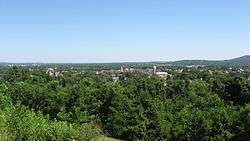
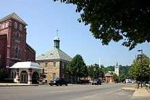
Overview of Chillicothe from Grandview Cemetery | ||
| ||
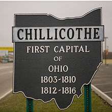
| Nickname(s): Ohio's First Capital | ||
 Location in the state of Ohio | ||
 Location of Chillicothe in Ross County | ||
| Coordinates: 39°20′11″N 82°59′2″W / 39.33639°N 82.98389°WCoordinates: 39°20′11″N 82°59′2″W / 39.33639°N 82.98389°W | ||
| Country | United States | |
| State | Ohio | |
| County | Ross | |
| Government | ||
| • Mayor | Luke Feeney (D) | |
| Area[1] | ||
| • Total | 10.60 sq mi (27.45 km2) | |
| • Land | 10.43 sq mi (27.01 km2) | |
| • Water | 0.17 sq mi (0.44 km2) | |
| Elevation | 630 ft (190 m) | |
| Population (2010)[2] | ||
| • Total | 21,901 | |
| • Estimate (2012[3]) | 21,735 | |
| • Density | 2,099.8/sq mi (810.7/km2) | |
| Time zone | EST (UTC-5) | |
| • Summer (DST) | EDT (UTC-4) | |
| ZIP code | 45601 | |
| Area code(s) | 740 | |
| FIPS code | 39-14184[4] | |
| GNIS feature ID | 1060960[5] | |
| Website | http://ci.chillicothe.oh.us/ | |
Chillicothe (/ˌtʃɪlᵻˈkɒθiː/ CHIL-ə-KOTH-ee)[6] is a city in and the county seat of Ross County, Ohio, United States.[7]
The population was 21,901 at the 2010 census. It is the only city in Ross County and the center of the Chillicothe Micropolitan Statistical Area (as defined by the United States Census Bureau in 2003). Chillicothe is a designated Tree City USA by the National Arbor Day Foundation.
History
Chillicothe was the first and third capital of Ohio and is located in southern Ohio along the Scioto River.
The town's name comes from the Shawnee Chala·ka·tha, named after one of the five major divisions of the Shawnee people, as it was the chief settlement of that tribal division. The Shawnee and their ancestors inhabited the territory for thousands of years prior to European contact. At the time of European-American settlement, the community was plotted by General Nathaniel Massie on his land grant.
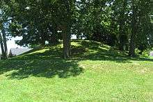
Modern Chillicothe was the center of the ancient Hopewell tradition, which flourished from 200 BC until 500 AD. This Amerindian culture had trade routes extending to the Rocky Mountains. They built earthen mounds for ceremonial and burial purposes throughout the Scioto and Ohio River valleys. Later Native Americans who inhabited the area through the time of European contact included Shawnees. Present-day Chillicothe is the most recent of seven locations in Ohio that bore the name, because it was applied to the main town wherever the Chalakatha settled.
Other population centers named Chillicothe in Ohio at one time[8] include: one located at present-day Piqua, in Miami County; one located south of present-day Circleville, Pickaway County, on the Scioto River; a third about three miles north of Xenia in Greene County, Ohio; a fourth at present-day Frankfort, Ross County, on Paint Creek; and a fifth also located in Ross County, at Hopetown, three miles north of modern Chillicothe.
According to historian Charles Augustus Hanna, a Shawnee village was founded at the site of modern-day Chillicothe in late 1758, following the destruction of Lower Shawneetown by floods.[9]
It was after the American Revolution that most European settlement came to this area. Migrants from Virginia and Kentucky moved west along the Ohio River in search of land. Chillicothe served as the capital of Ohio from the beginning of statehood in 1803 until 1810 when Zanesville became the capital for two years.[10] The capital was moved to Zanesville as part of a state legislative compromise to get a bill passed. In 1812 the legislature moved the capital back to Chillicothe. In 1816 the state legislature voted to move the capital again, to Columbus to have it near the geographic center of the state, where it would be more accessible to most citizens.[11]
Migrants to Chillicothe included free blacks, who came to a place with fewer restrictions than in the slave states. They created a vibrant community and aided runaway slaves coming north. As tensions increased prior to the breakout of the American Civil War, the free black community at Chillicothe maintained stations and aid to support refugees on the Underground Railroad. Slaves escaping from the South traveled across the Ohio River to freedom, and then up the Scioto River to get more distance from their former homes and slave hunters. White abolitionists aided the Underground Railroad as well.
Geography

Chillicothe is located at 39°20′11″N 82°59′2″W / 39.33639°N 82.98389°W (39.336525, −82.983822).[12] It lies within the ecoregion of the Western Allegheny Plateau.[13] It lies between the Scioto River and Paint Creek near their confluence.
According to the United States Census Bureau, the city has a total area of 10.60 square miles (27.45 km2), of which 10.43 square miles (27.01 km2) is land and 0.17 square miles (0.44 km2) is water.[1]
The city is surrounded by farming communities, and Chillicothe residents describe the area as the foothills of the Appalachians.
Demographics
| Historical population | |||
|---|---|---|---|
| Census | Pop. | %± | |
| 1820 | 2,426 | — | |
| 1830 | 2,846 | 17.3% | |
| 1840 | 3,977 | 39.7% | |
| 1850 | 7,100 | 78.5% | |
| 1860 | 7,626 | 7.4% | |
| 1870 | 8,920 | 17.0% | |
| 1880 | 10,938 | 22.6% | |
| 1890 | 11,288 | 3.2% | |
| 1900 | 12,976 | 15.0% | |
| 1910 | 14,508 | 11.8% | |
| 1920 | 15,831 | 9.1% | |
| 1930 | 18,340 | 15.8% | |
| 1940 | 20,129 | 9.8% | |
| 1950 | 20,133 | 0.0% | |
| 1960 | 24,957 | 24.0% | |
| 1970 | 24,842 | −0.5% | |
| 1980 | 23,420 | −5.7% | |
| 1990 | 21,923 | −6.4% | |
| 2000 | 21,796 | −0.6% | |
| 2010 | 21,901 | 0.5% | |
| Est. 2015 | 21,727 | [14] | −0.8% |
| Sources:[4][15][16][17][18][19] | |||
2010 census
As of the census[2] of 2010, there were 21,901 people, 9,420 households, and 5,559 families residing in the city. The population density was 2,099.8 inhabitants per square mile (810.7/km2). There were 10,600 housing units at an average density of 1,016.3 per square mile (392.4/km2). The racial makeup of the city was 88.1% White, 7.2% African American, 0.3% Native American, 0.5% Asian, 0.5% from other races, and 3.4% from two or more races. Hispanic or Latino of any race were 1.3% of the population.
There were 9,420 households of which 27.5% had children under the age of 18 living with them, 39.1% were married couples living together, 14.9% had a female householder with no husband present, 5.0% had a male householder with no wife present, and 41.0% were non-families. 34.6% of all households were made up of individuals and 14.3% had someone living alone who was 65 years of age or older. The average household size was 2.25 and the average family size was 2.87.
The median age in the city was 41.5 years. 21.8% of residents were under the age of 18; 7.7% were between the ages of 18 and 24; 24.8% were from 25 to 44; 27.8% were from 45 to 64; and 17.9% were 65 years of age or older. The gender makeup of the city was 47.6% male and 52.4% female.
2000 census
As of the census[4] of 2000, there were 21,796 people, 9,481 households, and 5,754 families residing in the city. The population density was 2,283.7 people per square mile (882.1/km²). There were 10,303 housing units at an average density of 1,079.5 per square mile (417.0/km²). The racial makeup of the city was 89.21% White, 7.51% African American, 0.34% Native American, 0.56% Asian, 0.04% Pacific Islander, 0.35% from other races, and 2.00% from two or more races. Hispanic or Latino of any race were 0.84% of the population.
There were 9,481 households out of which 25.8% had children under the age of 18 living with them, 43.5% were married couples living together, 13.3% had a female householder with no husband present, and 39.3% were non-families. 34.3% of all households were made up of individuals and 14.8% had someone living alone who was 65 years of age or older. The average household size was 2.24 and the average family size was 2.85.
In the city the population was spread out with 22.2% under the age of 18, 8.4% from 18 to 24, 27.1% from 25 to 44, 24.1% from 45 to 64, and 18.2% who were 65 years of age or older. The median age was 40 years. For every 100 females there were 88.1 males. For every 100 females age 18 and over, there were 83.3 males.
The median income for a household in the city was $33,991, and the median income for a family was $42,477. Males had a median income of $35,199 versus $25,010 for females. The per capita income for the city was $19,101. About 9.3% of families and 12.4% of the population were below the poverty line, including 14.3% of those under age 18 and 9.3% of those age 65 or over.
Government

Public officials
Chillicothe is governed by a mayor-council structure in which the mayor is elected separately from the members of the city council. Chillicothe's mayor is Luke Feeney (D).[20] The members of the city council are:
| Ward | City Council Member |
|---|---|
| First Ward | Beth Neal (D) |
| Second Ward | David Clay (R) |
| Third Ward | Alicia Gray (D) |
| Fourth Ward | David Tatman (D) |
| Fifth Ward | Joel Fleurima (D) |
| Sixth Ward | Pat Patrick (R) |
| At Large | Ceil Corcoran (D) |
| At Large | Dustin Proehl (D) |
| At Large | Josh Cartee (D) |
Other elected officials
| Officer | |
|---|---|
| Mayor | Luke Feeney (D) |
| Council President | Bruce Arnold (D) |
| Treasurer | Jeremy Siberell (R) |
| Auditor | (D) |
Public services
Parks and recreation
Chillicothe has several public parks, including Yoctangee Park, Poland Park, Strawser Park, Manor Park, Goldie Gunlock Park, Pine Street Park, Veterans Memorial Park, and Western View Park.
The biggest park, Yoctangee Park, consists of numerous baseball /softball fields, tennis courts, basketball courts, and playground equipment. There is also a skatepark within Yoctangee park called Henry Good skatepark, which was constructed with help from a generous donation of $65,000 from Henry Good, a local Chillicothe citizen.
Chillicothe's floodwall, protecting the city from floods of the Scioto River, has a 5.0-mile-long paved bike path. This path connects to the Tri-County Triangle Trail which currently is 30.3 miles long, measured from Bridge St. (SR 159) in Chillicothe, passing through Frankfort and then to Christman Park near Washington Court House. The Tri-County Triangle Trail's goal is to connect Chillicothe and Greenfield. This same former railroad continues to Jamestown and Xenia, but those connections are a long range plan.
Hopewell Culture National Historical Park is found on the north end of the city. The park is administered by the National Park Service and has a large concentration of Native American earthworks.
Education
A branch of Ohio University, Ohio University-Chillicothe is a public 4-year institution, that now offers a limited number of master's programs, which enrolls about 2,000 students each year. Ohio Christian University offers three associate degree programs, including Christian Ministry, Business Management, and Agribusiness and 5 Bachelor of Arts degrees, including Business Management, Health Care Management, Logistics, Psychology and Substance Abuse Counseling.
The city of Chillicothe provides education for pre-school through grade 12 students. The Chillicothe City School District includes the following facilities: Allen Elementary; Mt. Logan Elementary, previously Mt. Logan Middle School; Tiffin Elementary; Worthington Elementary; Chillicothe Middle School; and Chillicothe High School. Additionally, Wesley-Taylor Preparatory Academy offers private education. Bishop Flaget Catholic School, the parish school of St. Mary's and St. Peter's Catholic Churches, offers an academic program with the faith-based component to both Catholic and non-Catholic families for students in Prekindergarten through 8th grade.
Chillicothe is the home of Pickaway-Ross Career & Technology Center, located at 895 Crouse Chapel Road. Founded in 1974, Pickaway-Ross Career & Technology Center (or Pickaway-Ross) is the operational arm of the Pickaway-Ross Joint Vocational School District. Pickaway-Ross offers 20 high school tech-prep programs to students from 10 high schools in Ross and Pickaway counties. High school students attend Pickaway-Ross their junior and senior years, and can earn a Career Passport in addition to a diploma from their home schools. The high school (or secondary education) side of Pickaway-Ross serves approximately 600 students on its main campus and another 1,500 students in off-campus (or satellite) programs housed in affiliated high schools. School districts affiliated with Pickaway-Ross include: Adena, Chillicothe, Huntington, Paint Valley, Southeastern, Unioto, and Zane Trace in Ross County, and Circleville, Logan Elm and Westfall in Pickaway County. In addition to high school programs, Pickaway-Ross boasts a full-service Adult Education Division, offering a wide array of programs in skilled trades, public safety and medical services fields, to name a few. Pickaway-Ross is a regional leader in career tech education.
Chillicothe is also home to the Recording Workshop, an audio engineering school.
Culture
Majestic Theatre
Chillicothe is home to the 158-year-old continuously operating Majestic Theatre. Its stage has been graced by such greats as Laurel and Hardy, Milton Berle, George Arliss, Sophie Tucker, and many others. In 1853 the Masonic Hall was built, as the first incarnation of what is now the Majestic Theatre. The two-story brick building was a combination lodge room, dance hall, and theatre. Stock companies stayed for as long as a month, performing a repertory of plays. In 1876 the Masons appointed a building committee to enlarge their building. The original building was 40 ft. x 100 ft. and was extended to 50 ft. x 120 ft. Upon completion in December 1876 it was announced that the Masonic Opera House was one of the finest theatres in the state. After the remodeling and with the completion of the Clough Opera House across the city, theatre offerings were tremendous, and varied drama, comedy, farce, minstrel shows and operas were presented.
In 1904 A. R. Wolf bought the Masonic Opera House. Mr. Wolf remodeled the theatre and enlarged the stage. He replaced all the windows in the front of the building with stained glass windows. The Masonic Opera House continued under Wolf's managerial abilities until he sold it to the Myers Brothers in 1915. They again made some improvements and repairs and installed a movie screen and equipment. The Myers Brothers changed the name to the Majestic Theatre. They occasionally had live theatre productions on the stage but finally switched exclusively to motion pictures. In July 1971, Harley and Evelyn Bennett became the new owners of the Majestic Theatre. They did careful restoration with reference to the original wall painting. Three Chillicothe businessmen bought the theatre as a non-profit organization in 1990. All new wiring throughout the theatre, fire safety, and security systems were installed.
Fairs and festivals
Chillicothe, rich in Native American history, hosts the annual Feast of the Flowering Moon Festival. Started in 1984, the May festival draws crowds of approximately 85,000. Yoctangee Park, in the historic downtown, is the setting for this family-oriented, three-day event featuring Native American music, dancing, traders and exhibits, a mountain men encampment, rendezvous with working craftsmen and demonstrations, and an extensive arts and crafts show with more than 80 crafters and commercial exhibits. The main stage has a schedule of family-friendly entertainment, such as local school bands and performers. The streets are lined with food booths and games/contests. Events are free to the public.
On the Friday and Saturday after Labor Day in September, Chillicothe hosts the annual Southern Ohio Storytelling Festival. The festival features concert performances by several highly acclaimed and award-winning storytellers. Storytelling concerts are held throughout the day on both Friday and Saturday. Thousands of students participate during the day on Friday in various venues, including the Majestic Theatre, a tent at the Pump House Art Gallery in Yoctangee Park, and local school auditoriums.
Athletic events
The Chillicothe Paints are a baseball team that was established in February 1993. The team was previously a member of the Frontier League. Now a member of the summer collegiate Prospect League, the Paints played in the independent Frontier League from the 1993 season until the end of the 2008 season. They were one of the original teams in the league. The Paints play their home games at V.A. Memorial Stadium, which opened in 1954.
As the V.A. Memorial Stadium can be turned into a field for many uses, it also plays host to numerous sports events such as the M.A.C. Division baseball playoffs, OHSAA soccer playoffs, and OHSAA baseball playoffs.
In June, the streets of Chillicothe near Yoctangee Park are blocked off to accommodate temporary courts for the Gus Macker three-on-three basketball competition.
Notable people
Artists and architects
- Dave Canterbury, co-host Dual Survival Show
- Martha Finley, author of the Elsie Dinsmore series
- Eston Hemings, violinist and fiddler, son of Sally Hemings and President Thomas Jefferson
- Madison Hemings, Eston's brother, also a fiddler
- Dard Hunter, authority on printing, paper, and hand papermaking
- Billy Ireland, cartoonist
- Chip Mosher, columnist, poet, and educator
- Donald Ray Pollock, author
- Noel Sickles, illustrator
- Juliana Spahr, poet and professor
- Burton Egbert Stevenson, author
- Joe Waters, country music singer
- Nancy Wilson, singer
Athletes
- Scott Bailes, former Major League Baseball player
- Edward Cook, pole vaulter who competed at 1908 Summer Olympics and tied for gold with fellow American Alfred Gilbert[21]
- Greg Cook, Cincinnati Bengals quarterback
- Bobby Fulton, professional wrestler
- Ben Hartsock, Carolina Panthers tight end
- John Herrnstein, Philadelphia Phillies, University of Michigan football and baseball player
- Michael Hess, Pan American Games gold medal rower; competed at the 1976 Summer Olympics[22]
- Neil Johnston, NBA All-Star basketball player
- Elbie Nickel, Pittsburgh Steelers tight end
- Henry Orth, football player
- John Poff, MLB player for the Philadelphia Phillies and Milwaukee Brewers
- Ev Rowan, football player
- John Shoemaker, pro baseball player and minor-league manager
- Jimmy Strausbaugh, football player
- Garin Veris, defensive end, New England Patriots, Stanford University
Military
- Joshua W. Sill, brigadier general during the American Civil War
- Joseph S. Skerrett (1833–1897), United States Navy rear admiral
Ohio founders
- William Creighton, Jr., Ohio's first Secretary of State and designer of the Great Seal of Ohio
- Duncan McArthur, Ohio's 11th Governor
- Nathaniel Massie, first speaker of the Ohio Senate and founder of Chillicothe
- Edward Tiffin, first Governor of Ohio
- Thomas Worthington, "Father of Ohio Statehood" and Ohio's 6th Governor
Political figures
- Lucy Ware Webb Hayes, First Lady of the United States, wife of President Rutherford B. Hayes
- Thomas S. Hinde, city founder, writer, Methodist minister, and real estate investor
- Charles Henry Langston, abolitionist and educator in Ohio and Kansas
- John Mercer Langston, abolitionist, activist, educator and politician; first African-American in Ohio elected to public office
- David Leroy Nickens, first licensed African-American minister in Ohio
- Frederick Madison Roberts, California Assemblyman, believed to be the first African American elected to public office on the West Coast
- Robert Williamson Steele, first and only governor of the extralegal Jefferson Territory, a predecessor (1859–61) of Colorado Territory
- Lewis Woodson, AME minister, abolitionist, educator, one of the founders of Wilberforce University in 1856
Sister city
- Chillicothe is the sister city of Córdoba, Veracruz, Mexico. This relationship is honored through the Foreign Exchange Student Program with students at Chillicothe High School.
- Chillicothe also is the sister city of Tulua, Valle del Cauca, Colombia.
See also
References
- 1 2 "US Gazetteer files 2010". United States Census Bureau. Archived from the original on 2012-01-24. Retrieved 2013-01-06.
- 1 2 "American FactFinder". United States Census Bureau. Retrieved 2013-01-06.
- ↑ "Population Estimates". United States Census Bureau. Archived from the original on 2013-06-17. Retrieved 2013-06-17.
- 1 2 3 "American FactFinder". United States Census Bureau. Archived from the original on 2013-09-11. Retrieved 2008-01-31.
- ↑ "US Board on Geographic Names". United States Geological Survey. 2007-10-25. Retrieved 2008-01-31.
- ↑ "A Pronunciation Guide to Places in Ohio". E.W.Scripps School of Journalism. Retrieved 2008-12-19.
- ↑ "Find a County". National Association of Counties. Archived from the original on 2015-05-10. Retrieved 2011-06-07.
- ↑ "Ohio History Central, "Chillicothe, Ohio"". Retrieved 2016-04-10.
- ↑ Charles Augustus Hanna, The Wilderness Trail: Or, The Ventures and Adventures of the Pennsylvania Traders on the Allegheny Path, Volume 1, Putnam's sons, 1911; pp. 157-58.
- ↑ tfd. "Zanesville definition of Zanesville in the Free Online Encyclopedia". Retrieved 2007-11-24.
- ↑ tfd. "Chillicothe definition of Chillicothe in the Free Online Encyclopedia". Retrieved 2007-11-24.
- ↑ "US Gazetteer files: 2010, 2000, and 1990". United States Census Bureau. 2011-02-12. Retrieved 2011-04-23.
- ↑ "Level III Ecoregions of Ohio". National Health and Environmental Effects Research Laboratory. U.S. Environmental Protection Agency. Retrieved 28 September 2013.
- ↑ "Annual Estimates of the Resident Population for Incorporated Places: April 1, 2010 to July 1, 2015". Retrieved July 2, 2016.
- ↑ "Population: Ohio" (PDF). 1910 U.S. Census. U.S. Census Bureau. Retrieved 28 November 2013.
- ↑ "Population: Ohio" (PDF). 1930 US Census. U.S. Census Bureau. Retrieved 28 November 2013.
- ↑ "Number of Inhabitants: Ohio" (PDF). 18th Census of the United States. U.S. Census Bureau. Retrieved 22 November 2013.
- ↑ "Ohio: Population and Housing Unit Counts" (PDF). U.S. Census Bureau. Retrieved 22 November 2013.
- ↑ "Incorporated Places and Minor Civil Divisions Datasets: Subcounty Population Estimates: April 1, 2010 to July 1, 2012". U.S. Census Bureau. Archived from the original on 17 June 2013. Retrieved 25 November 2013.
- ↑ http://www.electionsonthe.net/oh/ross/elecres/20151103.htm
- ↑ "Ed Cook". Sports Reference. Retrieved December 2013. Check date values in:
|access-date=(help) - ↑ "Michael Hess". Sports Reference. Retrieved December 2013. Check date values in:
|access-date=(help)
External links
| Wikivoyage has a travel guide for Chillicothe, Ohio. |
- City website
- Pat Medert, "Chillicothe History"
- Chillicothe Gazette
- Downtown information
- Chamber of Commerce
- Chillicothe & Ross County Public Library
- Ross County Visitor's Bureau
Municipalities and communities of Ross County, Ohio, United States | ||
|---|---|---|
| City | 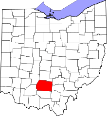 | |
| Villages | ||
| Townships | ||
| CDPs | ||
| Unincorporated communities | ||
| Ghost town | ||
| Footnotes | ‡This populated place also has portions in an adjacent county or counties | |