Chisago City, Minnesota
| Chisago City, Minnesota | |
|---|---|
| City | |
| Motto: "Gateway to the Lakes"[1] | |
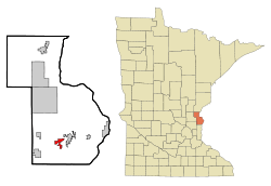 Location of Chisago City within Chisago County, Minnesota | |
| Coordinates: 45°21′54″N 92°53′12″W / 45.36500°N 92.88667°W | |
| Country | United States |
| State | Minnesota |
| County | Chisago |
| Area[2] | |
| • Total | 14.99 sq mi (38.82 km2) |
| • Land | 12.53 sq mi (32.45 km2) |
| • Water | 2.46 sq mi (6.37 km2) |
| Elevation | 925 ft (282 m) |
| Population (2010)[3] | |
| • Total | 4,967 |
| • Estimate (2012[4]) | 4,920 |
| • Density | 396.4/sq mi (153.1/km2) |
| Time zone | Central (CST) (UTC-6) |
| • Summer (DST) | CDT (UTC-5) |
| ZIP code | 55013 |
| Area code(s) | 651 |
| FIPS code | 27-11350[5] |
| GNIS feature ID | 0641169[6] |
| Website | www.ci.chisago.mn.us |
Chisago City (/ʃᵻˈsɑːɡoʊ ˈsɪti/ shə-SAH-go SIT-ee) is a city in Chisago County, Minnesota, United States, approximately 35 miles northeast of downtown Minneapolis–Saint Paul. The population was 4,967 at the 2010 census.[7]
The city is located between the twin lakes of Chisago Lake and Green Lake, and is part of the Chisago lakes region.
Geography
According to the United States Census Bureau, the city has a total area of 14.99 square miles (38.82 km2), of which, 12.53 square miles (32.45 km2) is land and 2.46 square miles (6.37 km2) is water.[2]
Infrastructure
Transportation
U.S. Highway 8 serves as a main route for the community.
History
Chisago City was founded by Swedish immigrants in the 1850s.[8] The city took its name from Chisago Lake.[9] It was originally settled one mile south, but when the railroad bypassed the town in 1880, the city moved closer to the railroad, as often happened during that time.[10]
Demographics
| Historical population | |||
|---|---|---|---|
| Census | Pop. | %± | |
| 1880 | 92 | — | |
| 1910 | 276 | — | |
| 1920 | 422 | 52.9% | |
| 1930 | 416 | −1.4% | |
| 1940 | 510 | 22.6% | |
| 1950 | 703 | 37.8% | |
| 1960 | 772 | 9.8% | |
| 1970 | 1,068 | 38.3% | |
| 1980 | 1,634 | 53.0% | |
| 1990 | 2,009 | 22.9% | |
| 2000 | 2,622 | 30.5% | |
| 2010 | 4,967 | 89.4% | |
| Est. 2015 | 4,932 | [11] | −0.7% |
| U.S. Decennial Census | |||
2010 census
As of the census[3] of 2010, there were 4,967 people, 2,051 households, and 1,306 families residing in the city. The population density was 396.4 inhabitants per square mile (153.1/km2). There were 2,209 housing units at an average density of 176.3 per square mile (68.1/km2). The racial makeup of the city was 96.7% White, 0.6% African American, 0.5% Native American, 0.6% Asian, 0.1% Pacific Islander, 0.3% from other races, and 1.1% from two or more races. Hispanic or Latino of any race were 1.7% of the population.
There were 2,051 households of which 29.8% had children under the age of 18 living with them, 51.9% were married couples living together, 7.5% had a female householder with no husband present, 4.3% had a male householder with no wife present, and 36.3% were non-families. 31.5% of all households were made up of individuals and 18.9% had someone living alone who was 65 years of age or older. The average household size was 2.35 and the average family size was 2.93.
The median age in the city was 43.3 years. 22.7% of residents were under the age of 18; 6.4% were between the ages of 18 and 24; 22.9% were from 25 to 44; 27.9% were from 45 to 64; and 20.2% were 65 years of age or older. The gender makeup of the city was 48.4% male and 51.6% female.
2000 census
As of the census[5] of 2000, there were 2,622 people, 1,038 households, and 685 families residing in the city. The population density was 1,329.0 people per square mile (513.9/km²). There were 1,107 housing units at an average density of 561.1 per square mile (217.0/km²). The racial makeup of the city was 97.10% White, 0.53% African American, 0.19% Native American, 0.46% Asian, 0.08% Pacific Islander, 0.57% from other races, and 1.07% from two or more races. Hispanic or Latino of any race were 1.60% of the population.
There were 1,038 households out of which 32.9% had children under the age of 18 living with them, 51.4% were married couples living together, 10.1% had a female householder with no husband present, and 34.0% were non-families. 29.2% of all households were made up of individuals and 17.1% had someone living alone who was 65 years of age or older. The average household size was 2.42 and the average family size was 2.96.
In the city the population was spread out with 25.1% under the age of 18, 8.0% from 18 to 24, 27.8% from 25 to 44, 18.1% from 45 to 64, and 21.0% who were 65 years of age or older. The median age was 38 years. For every 100 females there were 87.3 males. For every 100 females age 18 and over, there were 81.3 males.
The median income for a household in the city was $38,352, and the median income for a family was $51,964. Males had a median income of $38,988 versus $27,163 for females. The per capita income for the city was $22,321. About 3.8% of families and 6.0% of the population were below the poverty line, including 4.1% of those under age 18 and 8.0% of those age 65 or over.
See also
References
- ↑ "Chisago City Minnesota". Chisago City Minnesota. Retrieved October 4, 2012.
- 1 2 "US Gazetteer files 2010". United States Census Bureau. Archived from the original on 2012-01-24. Retrieved 2012-11-13.
- 1 2 "American FactFinder". United States Census Bureau. Retrieved 2012-11-13.
- ↑ "Population Estimates". United States Census Bureau. Archived from the original on 2013-06-17. Retrieved 2013-05-28.
- 1 2 "American FactFinder". United States Census Bureau. Archived from the original on 2013-09-11. Retrieved 2008-01-31.
- ↑ "US Board on Geographic Names". United States Geological Survey. 2007-10-25. Retrieved 2008-01-31.
- ↑ "2010 Census Redistricting Data (Public Law 94-171) Summary File". American FactFinder. U.S. Census Bureau, 2010 Census. Archived from the original on 21 July 2011. Retrieved 23 April 2011.
- ↑ Chisago City Heritage of Chisago City MN, Chisago County
- ↑ Upham, Warren (1920). Minnesota Geographic Names: Their Origin and Historic Significance. Minnesota Historical Society. p. 108.
- ↑ The Beginning
- ↑ "Annual Estimates of the Resident Population for Incorporated Places: April 1, 2010 to July 1, 2015". Retrieved July 2, 2016.
External links
| Wikimedia Commons has media related to Chisago City, Minnesota. |
- Chisago City Official Website
- Chisago City Heritage
- Chisago City, Minnesota at the Minnesota Historical Society.
- City-Data.com
Municipalities and communities of Chisago County, Minnesota, United States | ||
|---|---|---|
| Cities | 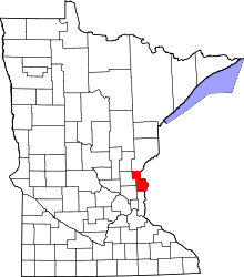 | |
| Townships | ||
| Unincorporated communities | ||
Coordinates: 45°22′25″N 92°53′24″W / 45.37361°N 92.89000°W