Cimarron, Kansas
| Cimarron, Kansas | |
|---|---|
| City | |
|
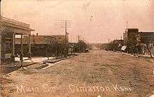
Historic 1886 Cimarron Hotel | |
 Location within Gray County and Kansas | |
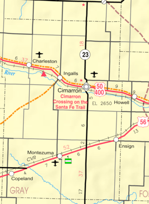 KDOT map of Gray County (legend) | |
| Coordinates: 37°48′30″N 100°20′51″W / 37.80833°N 100.34750°WCoordinates: 37°48′30″N 100°20′51″W / 37.80833°N 100.34750°W | |
| Country | United States |
| State | Kansas |
| County | Gray |
| Settled | 1878 |
| Area[1] | |
| • Total | 1.14 sq mi (2.95 km2) |
| • Land | 1.14 sq mi (2.95 km2) |
| • Water | 0 sq mi (0 km2) |
| Elevation | 2,635 ft (803 m) |
| Population (2010)[2] | |
| • Total | 2,184 |
| • Estimate (2015)[3] | 2,262 |
| • Density | 1,900/sq mi (740/km2) |
| Time zone | Central (CST) (UTC-6) |
| • Summer (DST) | CDT (UTC-5) |
| ZIP code | 67835 |
| Area code(s) | 620 |
| FIPS code | 20-13275 [4] |
| GNIS feature ID | 0471654 [5] |
| Website | CimarronKS.org |
_from_E_1.JPG)
Cimarron is a city in and the county seat of Gray County, Kansas, United States.[6] As of the 2010 census, the city population was 2,184.[7]
History
Cimarron was first settled in 1878.[8] It took its name from a fork in the Chisholm Trail which led travelers to the Cimarron River.[9]
Between 1887 and 1893, a county seat war took place in Gray County that involved several notable Old West figures, such as Bat Masterson, Bill Tilghman, and Ben Daniels. As a result of the dispute, Cimarron became the permanent county seat of Gray County.[10]
Geography
Cimarron is located at 37°48′30″N 100°20′51″W / 37.80833°N 100.34750°W (37.808332, −100.347413).[11] According to the United States Census Bureau, the city has a total area of 1.14 square miles (2.95 km2), all of it land.[1]
Climate
According to the Köppen Climate Classification system, Cimarron has a semi-arid climate, abbreviated "BSk" on climate maps.[12]
Demographics
| Historical population | |||
|---|---|---|---|
| Census | Pop. | %± | |
| 1900 | 237 | — | |
| 1910 | 587 | 147.7% | |
| 1920 | 599 | 2.0% | |
| 1930 | 1,035 | 72.8% | |
| 1940 | 1,004 | −3.0% | |
| 1950 | 1,189 | 18.4% | |
| 1960 | 1,115 | −6.2% | |
| 1970 | 1,373 | 23.1% | |
| 1980 | 1,491 | 8.6% | |
| 1990 | 1,626 | 9.1% | |
| 2000 | 1,934 | 18.9% | |
| 2010 | 2,184 | 12.9% | |
| Est. 2015 | 2,262 | [3] | 3.6% |
| U.S. Decennial Census | |||
2010 census
As of the census[2] of 2010, there were 2,184 people, 789 households, and 569 families residing in the city. The population density was 1,915.8 inhabitants per square mile (739.7/km2). There were 842 housing units at an average density of 738.6 per square mile (285.2/km2). The racial makeup of the city was 92.2% White, 0.1% African American, 0.5% Native American, 0.4% Asian, 5.4% from other races, and 1.3% from two or more races. Hispanic or Latino of any race were 19.1% of the population.
There were 789 households of which 41.7% had children under the age of 18 living with them, 58.2% were married couples living together, 10.8% had a female householder with no husband present, 3.2% had a male householder with no wife present, and 27.9% were non-families. 24.3% of all households were made up of individuals and 9.9% had someone living alone who was 65 years of age or older. The average household size was 2.73 and the average family size was 3.27.
The median age in the city was 33.6 years. 32.3% of residents were under the age of 18; 6.1% were between the ages of 18 and 24; 26% were from 25 to 44; 24% were from 45 to 64; and 11.5% were 65 years of age or older. The gender makeup of the city was 48.8% male and 51.2% female.
2000 census
As of the census[4] of 2000, there were 1,934 people, 720 households, and 526 families residing in the city. The population density was 2,119.9 people per square mile (820.6/km²). There were 749 housing units at an average density of 821.0 per square mile (317.8/km²). The racial makeup of the city was 92.50% White, 0.41% African American, 0.62% Native American, 0.16% Asian, 0.10% Pacific Islander, 4.86% from other races, and 1.34% from two or more races. Hispanic or Latino of any race were 9.82% of the population.
There were 720 households out of which 39.6% had children under the age of 18 living with them, 60.7% were married couples living together, 8.9% had a female householder with no husband present, and 26.9% were non-families. 24.3% of all households were made up of individuals and 11.1% had someone living alone who was 65 years of age or older. The average household size was 2.65 and the average family size was 3.17.
In the city the population was spread out with 30.6% under the age of 18, 8.3% from 18 to 24, 28.0% from 25 to 44, 21.7% from 45 to 64, and 11.4% who were 65 years of age or older. The median age was 34 years. For every 100 females there were 96.5 males. For every 100 females age 18 and over, there were 94.8 males.
The median income for a household in the city was $41,379, and the median income for a family was $48,636. Males had a median income of $31,402 versus $21,406 for females. The per capita income for the city was $17,970. About 4.6% of families and 6.9% of the population were below the poverty line, including 8.1% of those under age 18 and 9.5% of those age 65 or over.
Transportation
Notable people
- Ian Campbell, former defensive end for Kansas State University.
- Nicholas Klaine, journalist (editor of the Dodge City Times and New West Echo), built the Cimarron Hotel.
See also
References
- 1 2 "US Gazetteer files 2010". United States Census Bureau. Archived from the original on 2012-01-24. Retrieved 2012-07-06.
- 1 2 "American FactFinder". United States Census Bureau. Retrieved 2012-07-06.
- 1 2 "Annual Estimates of the Resident Population for Incorporated Places: April 1, 2010 to July 1, 2015". Retrieved July 2, 2016.
- 1 2 "American FactFinder". United States Census Bureau. Archived from the original on 2013-09-11. Retrieved 2008-01-31.
- ↑ "US Board on Geographic Names". United States Geological Survey. 2007-10-25. Retrieved 2008-01-31.
- ↑ "Find a County". National Association of Counties. Archived from the original on 2011-05-31. Retrieved 2011-06-07.
- ↑ "2010 City Population and Housing Occupancy Status". U.S. Census Bureau. Archived from the original on July 21, 2011. Retrieved March 27, 2011.
- ↑ Blackmar, Frank Wilson (1912). Kansas: A Cyclopedia of State History, Embracing Events, Institutions, Industries, Counties, Cities, Towns, Prominent Persons, Etc. Standard Publishing Company. p. 349.
- ↑ "Profile for Cimarron, Kansas". ePodunk. Retrieved 10 June 2014.
- ↑ "Feudin' and Fightin' Friday: County Seat Wars - Diggin' History". Retrieved 2014-04-06.
- ↑ "US Gazetteer files: 2010, 2000, and 1990". United States Census Bureau. 2011-02-12. Retrieved 2011-04-23.
- ↑ Climate Summary for Cimarron, Kansas
Further reading
- The Story of the Marking of the Santa Fe Trail by the Daughters of the American Revolution in Kansas and the State of Kansas; Almira Cordry; Crane Co; 164 pages; 1915.
- History of the State of Kansas; William G. Cutler; A.T. Andreas Publisher; 1883. (Online HTML eBook)
- Kansas : A Cyclopedia of State History, Embracing Events, Institutions, Industries, Counties, Cities, Towns, Prominent Persons, Etc; 3 Volumes; Frank W. Blackmar; Standard Publishing Co; 944 / 955 / 824 pages; 1912. (Volume1 – Download 54MB PDF eBook),(Volume2 – Download 53MB PDF eBook), (Volume3 – Download 33MB PDF eBook)
External links
| Wikimedia Commons has media related to Cimarron, Kansas. |
- City
- Schools
- USD 102, local school district
- Maps
- Cimarron City Map, KDOT
Municipalities and communities of Gray County, Kansas, United States | ||
|---|---|---|
| Cities | 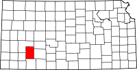 | |
| Unincorporated communities | ||
| Townships | ||