Claibourne, Ohio
| Claibourne, Ohio | |
|---|---|
| Unincorporated community | |
 Claibourne, Ohio Location of Claibourne, Ohio | |
| Coordinates: 40°23′17″N 83°20′57″W / 40.38806°N 83.34917°W | |
| Country | United States |
| State | Ohio |
| Counties | Union |
| Elevation[1] | 981 ft (299 m) |
| Time zone | Eastern (EST) (UTC-5) |
| • Summer (DST) | EDT (UTC-4) |
| ZIP code | 43344 |
| Area code(s) | 740 |
| GNIS feature ID | 1060971[1] |
Claibourne is an unincorporated community in Claibourne Township, Union County, Ohio, United States. It is located at 40°23′17″N 83°20′57″W / 40.38806°N 83.34917°WCoordinates: 40°23′17″N 83°20′57″W / 40.38806°N 83.34917°W,[2] at the intersection of Claibourne Road and Bethlehem-Claibourn Road.[3]
History
Claibourne was platted in 1881 when the railroad was extended to that point.[4] A post office was established at Claibourne in 1879, and remained in operation until 1947.[5]
References
- 1 2 "US Board on Geographic Names". United States Geological Survey. 2007-10-25. Retrieved 2008-01-31.
- ↑ U.S. Geological Survey Geographic Names Information System: Claibourne, Ohio
- ↑ Rand McNally. The Road Atlas '06. Chicago: Rand McNally, 2006, 78.
- ↑ Durant, Pliny A. (1883). The History of Union County, Ohio, containing a history of the county; its townships, towns ... Chicago: Beers, W. H., & co. p. 583.
- ↑ "Union County". Jim Forte Postal History. Retrieved 26 December 2015.
Municipalities and communities of Union County, Ohio, United States | ||
|---|---|---|
| Cities | 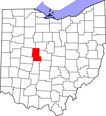 | |
| Villages | ||
| Townships | ||
| CDPs | ||
| Unincorporated communities | ||
| Ghost town | ||
| Footnotes | ‡This populated place also has portions in an adjacent county or counties | |
This article is issued from Wikipedia - version of the 12/27/2015. The text is available under the Creative Commons Attribution/Share Alike but additional terms may apply for the media files.