Clayton, Georgia
| Clayton, Georgia | |
|---|---|
| City | |
|
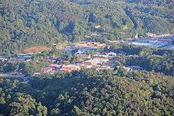
View of Clayton from Black Rock Mountain State Park | |
 Location in Rabun County and the state of Georgia | |
| Coordinates: 34°52′40″N 83°24′6″W / 34.87778°N 83.40167°WCoordinates: 34°52′40″N 83°24′6″W / 34.87778°N 83.40167°W | |
| Country | United States |
| State | Georgia |
| County | Rabun |
| Area | |
| • Total | 3.1 sq mi (8 km2) |
| • Land | 3.1 sq mi (8 km2) |
| • Water | 0 sq mi (0 km2) |
| Elevation | 1,929 ft (588 m) |
| Population (2011) | |
| • Total | 2,042 |
| • Density | 651.3/sq mi (252.4/km2) |
| Time zone | Eastern (EST) (UTC-5) |
| • Summer (DST) | EDT (UTC-4) |
| ZIP code | 30525 |
| Area code(s) | 706 |
| FIPS code | 13-16656[1] |
| GNIS feature ID | 0355183[2] |
Clayton is a city in Rabun County, Georgia, United States. The population was 2,019 at the 2000 census. The city is the county seat of Rabun County[3] and is located in the Blue Ridge Mountains.
History
The area that would eventually become Clayton was called the Dividings because it sat at the intersection of three important Cherokee people trails. Explorer and naturalist William Bartram came through the Dividings in May 1775 while exploring what would later be organized as Rabun County. Much later, after Clayton had grown to include the Dividings, two of the old Cherokee trails were improved as the main roads for Clayton and the county: U.S. 23/441 and U.S. 76.
Claytonsville was founded by European-American settlers in 1821 as the seat of Rabun County. In 1823, the town was incorporated and renamed Clayton.[4] It was named after a prominent jurist and congressman, Judge Augustin S. Clayton, who served in both the Georgia House of Representatives and Georgia Senate before being elected as a US Representative from Georgia, serving two terms from 1831–1835.
In 1824, 67 acres (270,000 m2) were purchased from Solomon Beck for $150, and city representatives laid out a site for a courthouse and the surrounding streets.
In 1904, the Tallulah Falls Railway was completed to Clayton from Cornelia, Georgia; it was extended to Franklin, North Carolina by 1907. Clayton has had public water and sanitary sewer service since the 1920s. Initially, the water supply was two springs on nearby Buzzard Roost Mountain, but today Clayton uses Lake Rabun as its water supply.
In 1936, Clayton recorded 30.0 inches (760 mm) of total snowfall, making that year the snowiest year in the city.[5] The recorded snowfall in Clayton in 1936 is also a state record.[6]
Part of Disney's Old Yeller was shot here in 1957.
Much of William Gibson's 2014 novel The Peripheral is set in Clayton in the not too distant future.
Geography
Clayton is located at 34°52′40″N 83°24′6″W / 34.87778°N 83.40167°W (34.877788, -83.401691)[7] and is situated at the southern base of 3,640-foot Black Rock Mountain. Immediately to the east of the city is 3,000-foot Screamer Mountain. Other Blue Ridge Mountain peaks between 2,500 and 3,500 feet surround the city.
According to the United States Census Bureau, the city has a total area of 3.1 square miles (8.0 km2), all of it land. The elevation of Clayton's downtown area is 1,925 feet (587 m). A number of hilltops within the city limits exceed 2,200 feet.
Demographics
| Historical population | |||
|---|---|---|---|
| Census | Pop. | %± | |
| 1870 | 70 | — | |
| 1880 | 180 | 157.1% | |
| 1900 | 199 | — | |
| 1910 | 541 | 171.9% | |
| 1920 | 677 | 25.1% | |
| 1930 | 798 | 17.9% | |
| 1940 | 1,088 | 36.3% | |
| 1950 | 1,302 | 19.7% | |
| 1960 | 1,507 | 15.7% | |
| 1970 | 1,569 | 4.1% | |
| 1980 | 1,838 | 17.1% | |
| 1990 | 1,613 | −12.2% | |
| 2000 | 2,019 | 25.2% | |
| 2010 | 2,047 | 1.4% | |
| Est. 2015 | 2,234 | [8] | 9.1% |
As of the 2010 United States Census, there were 2,047 people residing in the city. The racial makeup of the city was 74.5% White, 1.4% Black, 0.5% Native American, 0.7% Asian, 0.3% from some other race and 1.9% from two or more races. 20.8% were Hispanic or Latino of any race.
As of the census[1] of 2000, there were 2,019 people, 816 households, and 497 families residing in the city. The population density was 653.2 people per square mile (252.3/km²). There were 1,006 housing units at an average density of 325.5 per square mile (125.7/km²). The racial makeup of the city was 84.55% White, 2.77% African American, 0.89% Native American, 1.34% Asian, 0.15% Pacific Islander, 9.41% from other races, and 0.89% from two or more races. Hispanic or Latino of any race were 14.71% of the population.
There were 816 households out of which 22.7% had children under the age of 18 living with them, 44.7% were married couples living together, 11.2% had a female householder with no husband present, and 39.0% were non-families. 33.8% of all households were made up of individuals and 18.1% had someone living alone who was 65 years of age or older. The average household size was 2.29 and the average family size was 2.79.
In the city the population was spread out with 19.2% under the age of 18, 9.4% from 18 to 24, 26.3% from 25 to 44, 21.7% from 45 to 64, and 23.4% who were 65 years of age or older. The median age was 40 years. For every 100 females there were 99.1 males. For every 100 females age 18 and over, there were 93.0 males.
The median income for a household in the city was $26,600, and the median income for a family was $36,164. Males had a median income of $25,823 versus $18,304 for females. The per capita income for the city was $15,977. About 7.9% of families and 14.6% of the population were below the poverty line, including 14.3% of those under age 18 and 11.2% of those age 65 or over.
Education
Rabun County School District
The Rabun County School District holds pre-school to grade twelve, and consists of two elementary schools, a middle school, and a high school.[10] The district has 140 full-time teachers and over 2,221 students.[11]
- Rabun County Elementary School
- Rabun County Primary School
- Rabun County Middle School
- Rabun County High School
Private education
Camps
The area around Clayton has long been the location for a number of camps for young people, mostly operated during the summertime.
- Camp Ramah Darom is located in the Persimmon Valley northwest of Clayton.
- Camp Rainey Mountain is located 4 miles (6 km) southeast of Clayton.
- Camp Blue Ridge
Notable natives and residents
- Mike Ciochetti - stock car racer
- Billy Redden - actor who played the young banjo player in the film Deliverance (1972)
- Nancy Schaefer - Georgia State Senator
- Lillian Smith (1897-1966), - author and civil rights activist
References
- 1 2 "American FactFinder". United States Census Bureau. Archived from the original on 2013-09-11. Retrieved 2008-01-31.
- ↑ "US Board on Geographic Names". United States Geological Survey. 2007-10-25. Retrieved 2008-01-31.
- ↑ "Find a County". National Association of Counties. Archived from the original on 2011-05-31. Retrieved 2011-06-07.
- ↑ Hellmann, Paul T. (May 13, 2013). Historical Gazetteer of the United States. Routledge. p. 224. Retrieved 30 November 2013.
- ↑ Top Ten Snowiest Years in Clayton
- ↑ Georgia Snowfall Extremes Table
- ↑ "US Gazetteer files: 2010, 2000, and 1990". United States Census Bureau. 2011-02-12. Retrieved 2011-04-23.
- ↑ "Annual Estimates of the Resident Population for Incorporated Places: April 1, 2010 to July 1, 2015". Retrieved July 2, 2016.
- ↑ "Census of Population and Housing". Census.gov. Archived from the original on May 11, 2015. Retrieved June 4, 2015.
- ↑ Georgia Board of Education, Retrieved June 25, 2010.
- ↑ School Stats, Retrieved June 25, 2010.
External links
Municipalities and communities of Rabun County, Georgia, United States | ||
|---|---|---|
| Cities | 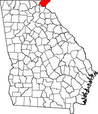 | |
| Towns | ||
| Unincorporated communities | ||
| Footnotes | ‡This populated place also has portions in an adjacent county or counties | |