Clyde, Arkansas
| Clyde, Arkansas | |
|---|---|
| Unincorporated community | |
|
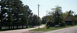
Clyde at the intersection of AR 45 and Washington County Route 8. | |
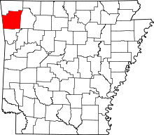
 Clyde, Arkansas  Clyde, Arkansas Clyde's position in Arkansas. | |
| Coordinates: 35°53′29″N 94°24′24″W / 35.89139°N 94.40667°WCoordinates: 35°53′29″N 94°24′24″W / 35.89139°N 94.40667°W[1] | |
| Country |
|
| State |
|
| County | Washington |
| Township | Cane Hill |
| Elevation[1] | 403 m (1,322 ft) |
| Time zone | Central (CST) (UTC-6) |
| • Summer (DST) | CDT (UTC-5) |
| ZIP code | 72717 |
| Area code(s) | 479 |
| GNIS feature ID | 76643 [1] |
Clyde, Arkansas (historically Newtown, Arkansas) is an unincorporated community in Cane Hill Township, Washington County, Arkansas, United States.[1] Clyde is on Arkansas Highway 45 about 26 miles southwest of Fayetteville and 6 miles east of the Oklahoma border.
Located within the Canehill, Arkansas ZIP code (72717), the population of the ZCTA was 847 at the 2000 census. It is part of the Fayetteville–Springdale–Rogers, AR-MO Metropolitan Statistical Area.
References
- 1 2 3 4 "Clyde". Geographic Names Information System. United States Geological Survey. Retrieved 2010-09-15.
This article is issued from Wikipedia - version of the 7/29/2016. The text is available under the Creative Commons Attribution/Share Alike but additional terms may apply for the media files.