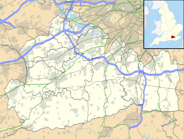
Cobham, Surrey
| Cobham | |
 Street off the High Street leading to the parish church |
|
 Cobham |
|
| Area | 8.29 km2 (3.20 sq mi) |
|---|---|
| Population | 9,739 (2011 census)[1] |
| – density | 1,175/km2 (3,040/sq mi) |
| OS grid reference | TQ1160 |
| – London | 17 mi (27 km) |
| Civil parish | n/a |
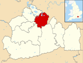
| District | Elmbridge |
| Shire county | Surrey |
| Region | South East |
| Country | England |
| Sovereign state | United Kingdom |
| Post town | Cobham |
| Postcode district | KT11 |
| Dialling code | 01932 |
| Police | Surrey |
| Fire | Surrey |
| Ambulance | South East Coast |
| EU Parliament | South East England |
| UK Parliament | Esher and Walton |
Coordinates: 51°19′44″N 0°24′32″W / 51.329°N 0.409°W
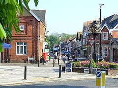
Cobham (/ˈkɒbəm/) is a village in the Borough of Elmbridge in Surrey, England, centred 17 miles (27 km) south-west of London[2] and 10 miles (16 km) northeast of Guildford on the River Mole. It has a commercial/services High Street, a significant number of primary and private schools and the Painshill landscape park.
History
Cobham is an ancient settlement whose origins can be traced back on the ground through Roman times to the Iron Age. It lay within the Elmbridge hundred.
Cobham appears in Domesday Book as Covenham and was held by Chertsey Abbey. Its domesday assets were: 12½ hides; 3 mills worth 13s 4d, 10 ploughs, 1-acre (4,000 m2) of meadow, woodland worth 40 hogs. It rendered altogether £14 per year to its feudal system overlords.[3] Coveham or Covenham is thought to mean a settlement in the curve of a river.
Historically, Cobham comprised two separate communities, Street Cobham and Church Cobham. The former lay on the road to London, and the building now known as the Cobham Exchange was once a coaching inn. The community of Church Cobham grew up around St. Andrew's Church, which dates from the 12th century. Although much altered and extended in the 19th century, the church preserves a Norman tower and is a Grade I listed building (the highest architectural category).[4][5]
The village's population was reported as 1617 inhabitants in 1848.[6] The arrival of the railway in the 1880s led to the expansion of the original village, which became increasingly suburbanised during the 20th century. Until the 1960s, the entrance to the High Street from River Hill to the south was very narrow. A number of historic and picturesque buildings were demolished at that time, some of them to enable the road to be widened, some to be replaced by contemporary buildings more suitable for shops. Subsequently the High Street has developed into a busy local shopping centre. Although many small shops such as greengrocers, butchers and haberdashers have disappeared, there remains a wide variety of businesses in the High Street and neighbouring streets.

Aviation and motor industries
Cobham is not far from Brooklands, and there was a certain amount of associated aviation and motoring activity at Cobham during the last century. Leading motor engineer and car designer Reid Railton set up a manufacturing facility and built Railton road cars at the Fairmile Works from 1933 to 1940. An example is displayed locally at Brooklands Museum.
In World War II, after the Vickers-Armstrongs aircraft factory at Brooklands was bombed by the Luftwaffe on 4 September 1940, with heavy loss of life and many more injured, the Vickers Experimental Department was quickly dispersed to secret premises on the Silvermere and Foxwarren Park estates along Redhill Road. Engineer and inventor Barnes Wallis also carried out important trials catapulting models of his 'Upkeep' bouncing bomb across Silvermere Lake around 1942 and conducted spinning trials with larger prototypes at 'Depot W46' (the largest of the three dispersed sites). Vickers had numerous other wartime dispersed depots in the local area, and those in Cobham included Corbie Wood and Riseholme (on Seven Hills Road), Conway Cottage and Norwood Farm.
Despite its proximity to both Brooklands and Wisley airfields (both active until the early 1970s), Cobham saw relatively few aircraft crashes. Most notable was a Lockheed P-38 Lightning fighter which flew low over Brooklands apparently in trouble and crashed at Cobham on 16 March 1944; the pilot survived but little else is known of this incident.
During World War II, another well-known aircraft company, Airspeed Ltd, apparently set up an almost forgotten design office at Fairmile Manor and is believed to have designed the Ambassador airliner there before moving back to Portsmouth in the late 1940s.
After the war, Vickers' Experimental Department continued to use two of the Redhill Road sites (now known as 'Foxwarren') and built new aircraft prototypes there such as the Viscount airliner and Valiant V-bomber, until it moved back to the main factory at Brooklands in the late 1950s.
In the 1970s Cobham resident Mike Chambers built Huron Formula Fords and a Formula Atlantic car at the Silvermere works on the north side of the A3, and Geoff Uren prepared the BMW team saloon cars and Graham Hill's Jägermeister-sponsored Formula 2 car.
From 1972 to 2011, the Cobham Bus Museum occupied a wartime aircraft hangar (used mainly by Vickers-Armstrongs as a machine shop) next to Silvermere golf course in Redhill Road. The bus museum reopened as the London bus museum at Brooklands Museum on 1 August 2011, and its former premises were demolished a few weeks earlier to be replaced by a new care home.
Geography
Boundaries
Cobham fits into a triangle between the M25 to the south, the A3 to the north and a borderline for the most part on the nearside of the (New) London to Guildford railway line to the east – directly west of Oxshott. On the southern border is the small, contiguous village, Stoke D'Abernon, part of the small post town, which gives its name to the railway station between the two areas on the line mentioned: Cobham and Stoke D'Abernon.
Soil and Elevation
- Soil
The village and its hamlets or neighbourhoods of Downside and Fairmile are on slowly permeable seasonally wet slightly acid but base-rich loamy and clayey soil, the east banks of the Mole are on free-draining gravel and alluvium and the west bank is heath which underlies the highest land in the east of the village. This land is an easterly outcrop of the Bagshot Sands (Formation).[7]
- Elevation
Watershed points, (in international terms), drainage divides at the summit of the sides of the lower Mole Valley in Cobham reach 60 metres (200 ft) and 65 metres (213 ft) towards the eastern borders close to Oxshott and in Stoke D'Abernon respectively.
The River Mole runs through Cobham, with a visitor area by the mill in the High Street, dividing the low-rise urban village/town centre and its major remaining agricultural parts in the west and south. This can flood small, old parts of the village centre in extreme rainfall. Elevation reaches a minimum here of 20 metres (66 ft) above sea level.[8][9]
Demography
Cobham has two wards; the Cobham Fairmile ward has a population of 4,760[10] neighbouring Cobham and Downside has a population of 6,158.[11]
Local area
 |
Weybridge | Hersham | Esher | |
| West Byfleet | |
Oxshott | ||
| ||||
| | ||||
| Ripley | East Horsley West Horsley |
Stoke D'Abernon |
On the outskirts of Cobham is Stoke d'Abernon, whose name is taken from a family who settled there at time of the Norman conquest in 1066.
The local newspaper was the Cobham News & Mail until it closed and was incorporated into the Surrey Advertiser.[12] Cobham is also covered by the Elmbridge Guardian, the Surrey Herald and the Surrey Comet newspapers.
Chelsea F.C.'s training ground is nearby, close to Cobham and Stoke d'Abernon railway station, and Cobham's exclusive private estates are home to many of Chelsea's players.
Landmarks

At the heart of Cobham is the Church Cobham Conservation Area, which was designated in 1973 and includes fourteen statutory listed buildings. Amongst these are Pyports,[13] once the home of Vernon Lushington; the picturesque Church Stile House;[14] and two fine houses overlooking the River Mole: Ham Manor[15] and Cedar House,[16] the latter owned by the National Trust.
Across the river from the church, the estate of Cobham Park was the home of John Ligonier, 1st Earl Ligonier, who was made Commander-in-Chief of the army in 1757. In 1806 Cobham Park was bought by Harvey Christian Combe a brewer and Lord Mayor of London. The present house was completed in 1873 by his nephew, Charles Combe, to a design by Edward Middleton Barry:[17] it has now been divided into apartments. At the other end of the town, beside the A3, Painshill Park is a fine 18th-century landscape garden, restored from dereliction since 1980. Painshill House dates from the 18th century and has also been divided into apartments.[18]
Two other large houses on the outskirts of Cobham have been taken over by schools: Heywood is now the American Community School,[19] and Burwood House is now Notre Dame School.[20]
Cobham Mill

The River Mole provides a setting for Cobham's best-known landmark which is the red brick water mill, constructed Late 18C and once part of a much larger complex.[21] [22] It stands on the site of earlier mills dating back to the Middle Ages. The mill was in use until 1928, when it became uneconomical to continue operating. Thereafter it was used as a storehouse.
During World War II, a Canadian tank collided with the main building, causing much damage.
In 1953 the main part of the mill was demolished by Surrey County Council to alleviate traffic congestion on Mill Road. This left just the grist mill standing.
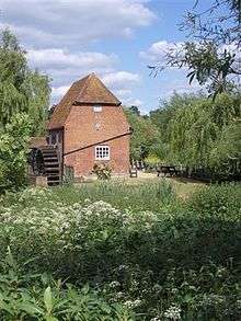
In 1973 the Cobham Conservation Group was formed, later to become the Cobham Conservation and Heritage Trust, and one of its main objectives was to rescue the much deteriorated grist mill building from sliding into the river as a result of water erosion of the mill island. In 1986 the freehold of the mill was taken over by the Thames Water Authority who, as part of their flood control requirements, needed to rebuild the weirs nearby. They also recognised that the mill was Grade II listed as therefore undertook to secure the mill's foundations.
Thereafter, the Cobham Mill Preservation Trust was formed as a sister organisation to the Cobham Conservation Group and took over the leasehold. The building was restored to full working order by the volunteers of the Cobham Mill Preservation Trust, and first opened to the public in 1993. Cobham Mill is now open to the public from 2 pm to 5 pm on the second Sunday of each month between April and October, inclusive.[23]
Education
St Andrew's Primary School[24] is located in the village as is Cobham Free School which is an all-through school.[25] A local prep school is Feltonfleet School. There are three independent schools: Notre Dame; ACS (The American Community Schools) Cobham International and Reed's School.[26]
Local leisure and entertainment
Painshill Park is nearby and Silvermere golf course is located in Redhill Road on the north side of the A3. Cobham has four football clubs: Cobham F.C., Mole Valley SCR F.C., Cobham United Football Club and Cobham Town FC (formed 2007). Cobham also has a cricket club, Cobham Avorians, formed in 1928. Avorians was named after its founder, local landowner Edward James Avory, and originally played at the Fairmile Estate before re-locating to Convent Lane on the Burwood Estate in 1948. Cobham Rugby Football Club has four teams which play regularly, as well as youth and mini sections.[27] There is Cobham Village Club and a branch of the Royal British Legion. Cobham Players[28] regularly present plays, musicals, pantomimes and other entertainments in Cobham.
Walton Firs Activity Centre lies just off the A3 in Cobham and covers 28 acres. It takes its name from Colonel Walton, who dealt with the purchase of the site in 1939. It was used by a Royal Artillery Anti-Aircraft Battery during World War II and in peacetime returned to use as a Scout camp site. During the 1990s some 3,000 additional trees were planted, and more recently an all-weather barn and an artificial, but realistic, caving complex have been added.
Local politics
The Member of Parliament is Conservative Dominic Raab[29] in the Esher and Walton constituency. Dominic succeeded Ian Taylor who stood down for the 2010 General Election. In local government Cobham is part of Elmbridge Borough Council and Surrey County Council. Divided into two wards, Cobham Fairmile[30] and Cobham & Downside[30] for Elmbridge voting, there are five councillors, all Conservative. For Surrey County voting, Cobham is paired with Stoke d'Abernon.
Cobham, with its many old buildings, conservation areas and housing development pressures has a very active Heritage Trust,[31] re-formed in 2007, and a lower-profile Residents Association.[32] Unlike neighbouring areas in Elmbridge, Residents and amenity groups[33] do not contest local elections in Cobham; occasionally independents have stood, such as in a 2007 by-election. The only non-Conservative elected was a Liberal/Focus[34] councillor, Mike King in 1984 in the Fairmile ward, which includes some high density social and private housing beside the A3, as well as more upmarket private estates. Cobham and Downside ward includes the village centre, private estates off the A245 Stoke Road, semi-rural Downside and into Hatchford south of the M25.
Since the 2013 Surrey County election, the local Member for Cobham is Conservative, Mrs Mary Lewis. A Cobham & Downside member on Elmbridge, Mike Bennison since 2005 also represents the next 3 stops up the line to London Oxshott Claygate and Hinchley Wood on Surrey County Council.
Road and rail links
To the north and west of the town is the A3 trunk road, a major arterial route from London to Portsmouth. This road links to the M25 motorway at Junction 10, immediately to the southwest of Cobham.
- The A307, Portsmouth Road starts in Cobham and runs northwards to the adjoining town of Esher. This is also known as the "old A3".
- The A245 runs through the centre of the town and leads to Leatherhead in the south-east and Byfleet to the west.
Cobham & Stoke d'Abernon railway station, opened in 1885, is on the "New Guildford Line" from London Waterloo.
Police and fire services
The Cobham Police Station has closed, so the nearest police station is Kingston upon Thames some 8 miles away
- Surrey Fire & Rescue Service, called Painshill Fire Station, has a full-time crew together with:
- 1 Water Tender Ladder
- 1 Incident Command Unit
- 1 Forward Command Vehicle
Notable people
- John Addison, (1920–1998), composer, was born in Cobham.[35]
- Matthew Arnold, (1822–1888), poet, lived in Cobham from 1873 to 1888.[36]
- Malcolm Arbuthnot, (1877–1967), pictorialist, photographer and artist, was born in Cobham.[37]
- Sir Felix Aylmer, (1889–1979), actor, lived at Painshill House, Cobham in the 1970s.[38]
- General Sir Thomas Brotherton, (1785–1868), died nearby and is buried in St. Andrew's churchyard.[39]
- Harvey Christian Combe, (1752–1818), brewer, Lord Mayor of London, owner of Cobham Park
- Aaron Eckhart, (born 1968), American actor and co-star of the Dark Knight, lived in Cobham and attended the American Community School.[40]
- Shane Filan, (born 1979), singer, former member of Westlife, has homes in Cobham and Sligo, Ireland.
- Harold B. Hudson, (1898–1982), World War I flying ace, was born in Cobham.[41]
- Nick Jones, (born 1963), entrepreneur, owner of Babington House and husband of Kirsty Young, grew up in Cobham.
- John Ligonier, 1st Earl Ligonier, (1680–1770), Commander-in-Chief of the British Army, lived at Cobham Park.[5]
- Vernon Lushington, (1832–1912), lawyer and patron to the arts, lived at Pyports in Cobham.[42]
- Sir (Albert) Noel Campbell Macklin (1886–1946), of Fairmile estate, a British car maker and boat designer.
- Kenneth McAlpine (born 1920), racing driver, was born in Cobham.[43]
- Admiral Sir Graham Moore, (1764–1843), naval officer, lived at Brook Farm in Cobham [5] and is buried in St. Andrew's churchyard.[44]
- Lieutenant-General Lord Henry Percy VC KCB, (1817–1877), soldier and MP, was born at Burwood House (now Notre Dame School).[45]
- Sir Thomas Sopwith, (1888–1989), aviation pioneer and industrialist who founded the Sopwith Aviation, H G Hawker Engineering, Hawker Aircraft and Hawker Siddeley aircraft companies, lived at Compton House, Cobham in the 1920s.[46]
- Fred Stedman, (1870–1918), Surrey county cricketer, was born in Cobham.[47]
- Gerrard Winstanley, (1609–1676), reformer, lived in Cobham from 1643 and was churchwarden in 1667-8.[48]
Demography and housing
| Output area | Detached | Semi-detached | Terraced | Flats and apartments | Caravans/temporary/mobile homes | Shared between households[1] |
|---|---|---|---|---|---|---|
| Cobham Fairmile (ward) | 792 | 366 | 274 | 262 | 1 | 2 |
| Centre and south[n 1] | 1,157 | 687 | 401 | 507 | 4 | 2 |
The average level of accommodation in the region composed of detached houses was 28%, the average that was apartments was 22.6%.
| Output area | Population | Households | % Owned outright | % Owned with a loan | hectares[1] |
|---|---|---|---|---|---|
| Cobham Fairmile (ward) | 4,751 | 1,697 | 34 | 32 | 553 |
| Centre and south | 4,988 | 2,047 | 40 | 31 | 276 |
The proportion of households in the settlement who owned their home outright compares to the regional average of 35.1%. The proportion who owned their home with a loan compares to the regional average of 32.5%. The remaining % is made up of rented dwellings (plus a negligible % of households living rent-free).
In film, fiction and the media
Elmbridge has been acclaimed by the Daily Mail as the best place to live in the UK, citing the town among features contributing to its article headed 'the UK's Beverley Hills', and Cobham is overall a high average earnings part of the London commuter belt.
Nearest places
- Stoke D'Abernon
- Oxshott
- Esher
- Leatherhead
- Hersham
- Weybridge
- Walton-on-Thames
- Effingham
- Byfleet
- East Horsley
- West Horsley
- [(Downside)]
Bibliography
- Taylor, David, C (2003) 'Cobham - A History' (Phillimore & Co Ltd, Chichester, ISBN 1-86077-247-1)
Notes and references
- Notes
- ↑ Cobham and Downside (ward) less Elmbridge 017C
- References
- 1 2 3 By convention, Cobham is not deemed to include any longer the village of Downside, Surrey which would otherwise cover in total 17.12km² Key Statistics; Quick Statistics: Population Density United Kingdom Census 2011 Office for National Statistics Retrieved 21 November 2013
- ↑ Grid Reference Finder distance tools
- ↑ "Doomsday Sudrie (Surry)". Surrey Domesday Book. Archived from the original on 23 December 2004. Retrieved 2 July 2010.
- ↑ "St. Andrew's Church". britishlistedbuildings. Retrieved 7 November 2011.
- 1 2 3 "Victoria County History". British History Online. Retrieved 8 November 2011.
- ↑ "A Topological Dictionary of England".
- ↑ Cranfield University National Soil Resources Institute
- ↑ Grid square map Ordnance survey website Retrieved 2013-10-13
- ↑ Cobham Conservation & Heritage Trust (Improvements at River Hill, Cobham) Flood Risk Assessment Bell Fischer Retrieved 2013-10-13
- ↑ "Census data - Area: Cobham Fairmile (Ward) - Key Figures for 2001 Census". Office for National Statistics. Retrieved 2 July 2010.
- ↑ "Census data - Area: Cobham and Downside (Ward) - Key Figures for 2001 Census". Office for National Statistics. Retrieved 2 July 2010.
- ↑ "Esher and Elmbridge". Cobham News & Mail. Retrieved 2 July 2010.
- ↑ "Pyports". britishlistedbuildings. Retrieved 7 November 2011.
- ↑ "Church Stile House". britishlistedbuildings. Retrieved 7 November 2011.
- ↑ "Ham Manor". britishlistedbuildings. Retrieved 7 November 2011.
- ↑ "Cedar House". britishlistedbuildings. Retrieved 7 November 2011.
- ↑ "Cobham Park". britishlistedbuildings. Retrieved 7 November 2011.
- ↑ "Painshill House". britishlistedbuildings. Retrieved 7 November 2011.
- ↑ "Heywood". britishlistedbuildings. Retrieved 8 November 2011.
- ↑ "Notre Dame School". britishlistedbuildings. Retrieved 8 November 2011.
- ↑ Historic England. "Details from listed building database (1190885)". National Heritage List for England. Retrieved 2 October 2015.
- ↑ "Cobham Mill". britishlistedbuildings. Retrieved 7 November 2011.
- ↑ http://www.cobhammill.org.uk/
- ↑ "Welcome to St Andrew's Primary School". St Andrew’s Primary School. Retrieved 2 July 2010.
- ↑ http://www.cobhamfreeschool.org.uk/
- ↑ "Home-Whats on-news". Reed's School. Retrieved 2 July 2010.
- ↑ "Welcome to Cobham Rugby". Cobham Rugby Club. Retrieved 2 July 2010.
- ↑ "Cobham Players-presenting plays since 1948". cobhamplayers.org.uk. Retrieved 2 July 2010.
- ↑ "Dominic Raab". Dominic Raab. Retrieved 2 July 2010.
- 1 2 "Ward Members". Elmbridge Borough Council. Retrieved 2 July 2010.
- ↑ "Latest news". Cobham Conservative and Heritage Trust. Retrieved 2 July 2010.
- ↑ "Welcome to the CDRA". Coham and Downside Residents Association. Retrieved 2 July 2010.
- ↑ "News and events". Elmsbridge residents group. Retrieved 2 July 2010.
- ↑ "Welcome to Esher and Walton Lib Dems' website". Libdems.org. Retrieved 2 July 2010.
- ↑ Gleason, Alexander (12 December 1998). "John Addison". London: independent.co.uk. Retrieved 8 November 2011.
- ↑ "Matthew Arnold". Representative Poetry Online. Retrieved 8 November 2011.
- ↑ "Malcolm Arbuthnot". kittybrewster.com. Retrieved 7 November 2011.
- ↑ "Felix Aylmer". Oxford Dictionary of National Biography. Retrieved 8 November 2011.
- ↑ "Thomas William Brotherton". Esher District Local History Society. Retrieved 8 November 2011.
- ↑ Bedell, Geraldine (4 April 2004). "Mormon becomes electric". The Guardian. London. Retrieved 8 November 2011.
- ↑ "Harold B. Hudson". theaerodrome.com. Retrieved 8 November 2011.
- ↑ "Vernon Lushington". cobhamvillage.co.uk. Retrieved 8 November 2011.
- ↑ Jenkins, Richard. "The World Championship drivers - Where are they now?". OldRacingCars.com. Retrieved 8 November 2011.
- ↑ "Moore Tomb". britishlistedbuildings. Retrieved 8 November 2011.
- ↑
 "Percy, Henry Hugh Manvers". Dictionary of National Biography. London: Smith, Elder & Co. 1885–1900.
 - ↑ Gwyther, Matthew (15 July 2000). "Sir Thomas Sopwith". London: telegraph.co.uk. Retrieved 9 November 2011.
- ↑ "Fred Stedman". CricketArchive. Retrieved 7 November 2011.
- ↑ "Gerrard Winstanley". The Digger Archives. Retrieved 8 November 2011.
External links
- Aerial photographs of Cobham
- Cobham Conservation and Heritage Trust
- Cobham Mill Preservation Trust
- Official website for Cobham Rugby Football Club
- Official website for Cobham Sports Association incorporating Cobham Rugby, Cobham Tennis and Cobham Cricket
- Cobham Players
- Cobham Avorians Cricket Club
| Towns, villages and neighbourhoods |
|  | ||||||||||||||||||||||||||||||
|---|---|---|---|---|---|---|---|---|---|---|---|---|---|---|---|---|---|---|---|---|---|---|---|---|---|---|---|---|---|---|---|---|
| Notable Parks | ||||||||||||||||||||||||||||||||
| Grade I Listed Churches | ||||||||||||||||||||||||||||||||
| Education | ||||||||||||||||||||||||||||||||
| Transport |
| |||||||||||||||||||||||||||||||
| Buildings and structures |
| |||||||||||||||||||||||||||||||
| Sport | ||||||||||||||||||||||||||||||||
Places listed are articles notable as settlements, arranged by post town The M25 motorway follows approximately a boundary and is included for its regional importance. | ||||||||||||||||||||||||||||||||