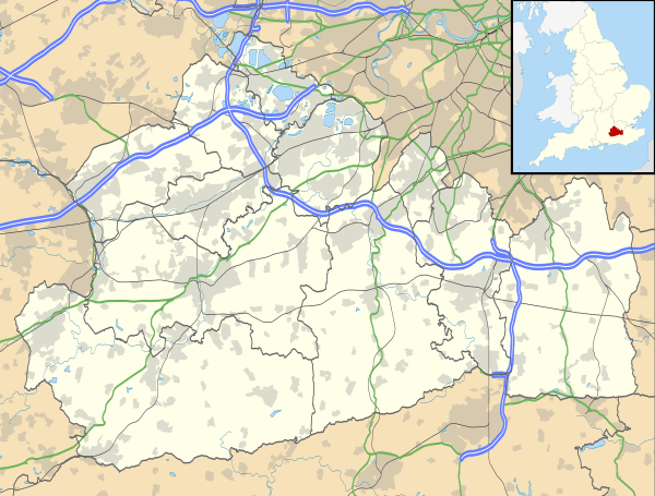
Long Ditton
| Long Ditton | |
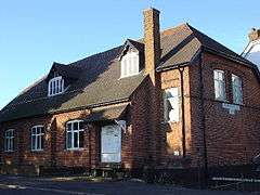 The Village Hall |
|
 Long Ditton |
|
| Area | 2.14 km2 (0.83 sq mi) |
|---|---|
| Population | 6,343 (2011 census)[1] |
| – density | 2,964/km2 (7,680/sq mi) |
| OS grid reference | TQ169664 |
| Civil parish | n/a |
| District | Elmbridge |
| Shire county | Surrey |
| Region | South East |
| Country | England |
| Sovereign state | United Kingdom |
| Post town | Surbiton Thames Ditton[n 1] |
| Postcode district | KT6 KT7 |
| Dialling code | 020 |
| Police | Surrey |
| Fire | Surrey |
| Ambulance | South East Coast |
| EU Parliament | South East England |
| UK Parliament | Esher and Walton |
Coordinates: 51°23′06″N 0°19′16″W / 51.385°N 0.321°W
Long Ditton is a residential suburb in Surrey, England on the boundary with the Royal Borough of Kingston upon Thames, London. In medieval times it was a village, occupying a narrow strip of land. Neighbouring settlements include Hinchley Wood, Thames Ditton and Surbiton.
Its northernmost part is 1.5 miles (2.4 km) south-west of central Kingston upon Thames, 11.3 miles from Charing Cross, and 15 miles (24 km) north-east of Guildford, the county town. It is briefly cut in its middle by the South Western Main Line and is bordered by a straight east-west spur road to meet the A3 in a cutting to the south. The old Portsmouth Road passes by the River Thames in the northern end of the village and the south bank here is privately owned.
In both local economy and public transport the high street and railway stations at Hinchley Wood and Surbiton are the nearest such amenities. Surbiton has many restaurants and cafés.
History
(in winter, built 1880.)
Ditton was a Saxon settlement which, by Domesday, was a single ecclesiastical parish but split in two, as it remains. This split was between the riverside manor and parish of Thames Ditton, and the longer, eastern area, Long Ditton, which is a long rectangle of land extending from developed land by the River Thames to Ditton Hill. Nowadays Ditton Hill reaches beyond the wide A3 and A309 as far as Woodstock Lane South, much of which is in Claygate parish (and has an Esher postal address).[2]
Two Dittons appear in the Domesday Book of 1086 and were written as Ditone and Ditune. The one that became known as Long Ditton was held by Picot from (i.e. under) Richard Fitz Gilbert. The one that became known as Thames Ditton was held by Wadard under Bishop Odo. Long Ditton's Domesday assets were: 4 hides; 1 church, 1 mill worth 9s, 3½ ploughs, woodland for 15 hogs, 1 house in Southwark paying 500 herrings. It rendered £2 10s 0d.[3]
The ancient church dates in part from the 12th century. It had fallen into a bad state of decay by the 18th century. Various manors here supported the church and in return the vestry supported its inhabitants, including two in Tolworth.[4]
Merton Priory received all four neighbouring chapelries to Kingston under Henry I, therefore it is uncertain whether the manor had a church or chapel here at that period. Until the early 20th century the parish had two non-contiguous parts, Long Ditton proper and an exclave in Tolworth. A strip of Kingston parish, its hamlet of Hook, lay between the two parts. The western portion, Long Ditton proper, had 896 acres (363 ha)[4] and had near-identical boundaries to today's ecclesiastical parish.
In the 18th century a replacement church was built on its site, with a small Greek cross plan, built of brick.[4]
With only the church listed buildings many properties are Victorian – the rectory became very derelict in the early 20th century and it was decided to demolish it. Its greater part was half-timber; it is pictured in Malden's book on the county of Surrey, and is probably from the 16th century.[4] In that century what is known of the village is its manor fell into the hands of George Evelyn, whose family took a dynastic hold over the village's prosperity. The Evelyns had the foresight, or good fortune, to be producing gunpowder during a rather explosive period of history. Gunpowder mills proliferated across Long Ditton and beyond to keep up with demand, and the Evelyns set about buying up much of the country that was heavily involved in the English Civil War, using the profits from gunpowder.[4]
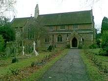
George's grandson John Evelyn, who gained posthumous fame for his Diary, had to flee the country during the Civil War as swathes of family land fell awkwardly between Royalist and Parliamentarian strongholds. It was John who gleaned further prestige for the family name with his assimilation into the Royal Court of Charles II. When St Mary's Church was rebuilt in 1880, and monuments erected to commemorate local dignitaries, there were few other Long Ditton celebrities to celebrate, and the place became something of an Evelyn shrine.[4]
People buried in the churchyard include global businessman and civil structural engineer Terence Patrick O'Sullivan, Sir Sydney Camm (aircraft design engineer for Hawker) and Austin Partner, a victim of the sinking of the Titanic.[5]
Remains of the 18th century on-site replacement for the medieval church can be seen in the churchyard's garden of rest, strewn with flat, crypt-style church floor memorials to the Evelyn family; it is Grade II listed.[6] Only one of its memorials was moved to the present Church of England (parish) church built in 1880, designed by George Edmund Street. Built of expensive stone material, it is primarily of buff-covered coursed marble stone with Bath stone dressings overlying this in part, forming decorative arches.[7]
Demography
A small part of the electoral ward, Long Ditton, was in the 2000s exchanged, including adding to Hinchley Wood (south of Hinchley Wood railway station).
The Long Ditton ward's population at the 2011 census was 6,343 living in 2,504 households. The total area was unchanged from ten years before at 214 hectares (530 acres) and the density had increased to 27.2 to 29.6 persons per hectare.[1]
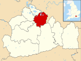
Geography
 |
Thames Ditton | Across the River Thames Hampton Court Gardens |
Seething Wells, Surbiton | |
| Thames Ditton | |
Southborough, Surbiton Hook | ||
| ||||
| | ||||
| Hinchley Wood | Claygate | Chessington |
The place is one of only two small portions of Elmbridge that is part of a post town outside its area, in this case, Surbiton which is in the neighbouring borough of Kingston upon Thames.
Soil and Elevation
Long Ditton's soil is chiefly London clay, but to the north is Thames alluvial topsoil, gravel and sand, and it contains two patches of Bagshot Sand in the southern part.
Economy
Residential estates have been built on Long Ditton's former agricultural land, and it has become a dormitory settlement, and a satellite suburb to Esher, Kingston upon Thames and Surbiton. The nearest railway stations are Thames Ditton and Surbiton. Long Ditton is also served by buses.
It can be claimed that Long Ditton has retained its village character: it has village hall events and a cricket club. It is a clustered village, which has now developed its riverside.Modest green spaces are interspersed with housing in the area; they are principally recreation grounds and do not form buffer zones with other settlements, except some commercial plant nurseries and garden centre businesses which separate Long Ditton from Claygate.
Residents' Association
The Long Ditton Residents' Association (LDRA) is a subscription-based body whose aims are to preserve Long Ditton from overdevelopment, maintain its character, improve its amenities and defend its remaining surrounding Metropolitan Green Belt.[8]
Demography and housing
| Output area | Detached | Semi-detached | Terraced | Flats and apartments | Caravans/temporary/mobile homes | Shared between households[1] |
|---|---|---|---|---|---|---|
| (ward) | 703 | 706 | 669 | 419 | 7 | 0 |
The average level of accommodation in the region composed of detached houses was 28%, the average that was apartments was 22.6%.
| Output area | Population | Households | % Owned outright | % Owned with a loan | hectares[1] |
|---|---|---|---|---|---|
| (ward) | 6,343 | 2,504 | 33 | 44 | 214 |
The proportion of households in the settlement who owned their home outright compares to the regional average of 35.1%. The proportion who owned their home with a loan compares to the regional average of 32.5%. The remaining % is made up of rented dwellings (plus a negligible % of households living rent-free).
Notes and references
- ↑ Surbiton is for the majority of Long Ditton the post town.
- References
- 1 2 3 4 Key Statistics; Quick Statistics: Population Density United Kingdom Census 2011 Office for National Statistics Retrieved 21 November 2013
- ↑ Ecclesiastical Parish (an Ancient Parish in this instance), definition
- ↑ Surrey Domesday Book
- 1 2 3 4 5 6 H.E. Malden (editor) (1911). "Parishes: Long Ditton". A History of the County of Surrey: Volume 3. Institute of Historical Research. Retrieved 30 September 2013.
- ↑ encyclopedia-titanica.org
- ↑ Remains of the old church Historic England. "Details from listed building database (1377470)". National Heritage List for England.
- ↑ Church of St Mary Historic England. "Details from listed building database (1188093)". National Heritage List for England.
- ↑ Long Ditton Residents' Association Website
- Notes
External links
![]() Media related to Long Ditton at Wikimedia Commons
Media related to Long Ditton at Wikimedia Commons
| Towns, villages and neighbourhoods |
|  | ||||||||||||||||||||||||||||||
|---|---|---|---|---|---|---|---|---|---|---|---|---|---|---|---|---|---|---|---|---|---|---|---|---|---|---|---|---|---|---|---|---|
| Notable Parks | ||||||||||||||||||||||||||||||||
| Grade I Listed Churches | ||||||||||||||||||||||||||||||||
| Education | ||||||||||||||||||||||||||||||||
| Transport |
| |||||||||||||||||||||||||||||||
| Buildings and structures |
| |||||||||||||||||||||||||||||||
| Sport | ||||||||||||||||||||||||||||||||
Places listed are articles notable as settlements, arranged by post town The M25 motorway follows approximately a boundary and is included for its regional importance. | ||||||||||||||||||||||||||||||||