Comstock's Bridge
|
Comstock's Bridge | |
 | |
  | |
| Location | East Hampton, Connecticut |
|---|---|
| Coordinates | 41°33′11″N 72°26′57″W / 41.55306°N 72.44917°WCoordinates: 41°33′11″N 72°26′57″W / 41.55306°N 72.44917°W |
| Area | 1 acre (0.40 ha) |
| Built | 1840 |
| Architectural style | Howe-truss covered bridge |
| NRHP Reference # | 76001978[1] |
| Added to NRHP | January 1, 1976 |
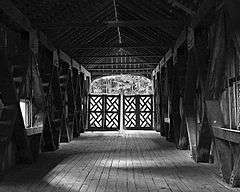
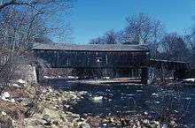
Comstock's Bridge, also known as the Comstock Covered Bridge, is a covered bridge located in East Hampton, Connecticut. The bridge was built in 1840 to span the Salmon River, and is one of only three historical covered bridges in the state. The main span is a Howe truss, 80 feet (24 m) long, with a roadbed 12 feet (3.7 m) wide. A secondary span, 30 feet (9.1 m) in length, connects the bridge to the eastern shore. The bridge underwent major restoration work in the 1930s after a truck crashed through the floor; it is now closed to traffic, and is accessible from a small public park.[2]
The bridge was listed on the National Register of Historic Places on January 1, 1976.[1]
See also
Comstock's Bridge in 1970
- National Register of Historic Places listings in Middlesex County, Connecticut
- List of bridges on the National Register of Historic Places in Connecticut
References
- 1 2 National Park Service (2009-03-13). "National Register Information System". National Register of Historic Places. National Park Service.
- ↑ Bruce Clouette (July 25, 1975). "National Register of Historic Places Inventory-Nomination: Comstock's Bridge" (PDF). National Park Service. and Accompanying three photos, from 1975
External links
| Topics | |
|---|---|
| Lists by states |
|
| Lists by insular areas | |
| Lists by associated states | |
| Other areas | |
| |
This article is issued from Wikipedia - version of the 11/27/2016. The text is available under the Creative Commons Attribution/Share Alike but additional terms may apply for the media files.