Conchas Lake
| Conchas Lake | |
|---|---|
| Location | San Miguel County, New Mexico, United States |
| Coordinates | 35°22′48″N 104°13′52″W / 35.380°N 104.231°WCoordinates: 35°22′48″N 104°13′52″W / 35.380°N 104.231°W |
| Type | reservoir |
| Catchment area | 7,409 sq mi (19,190 km2)[1] |
| Basin countries | United States |
| Max. length | 25 mi (40 km) |
| Water volume | 709,119 acre·ft (874,685 dam3)[1] |
| Surface elevation | 4,200 ft (1,280 m) |
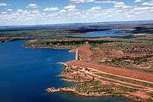
Conchas Lake is a 25-mile (40 km) long reservoir in northeastern New Mexico, behind Conchas Dam on the Canadian River. The lake has an elevation of 4,200 feet (1309.2 meters) and a surface area of 9,600 acres.
Conchas Dam was completed in 1939 by the United States Army Corps of Engineers.[2]
Adjacent to the lake is Conchas Lake State Park, which is divided into two separate areas, north and south. The state park has nine public boat ramps: five in the north area and four in the south area. The lake contains walleye, largemouth bass, White bass, Shad, Flathead catfish, channel catfish, bluegill, and crappie. The south area is located between the town of Conchas and Hooverville. Visitors can access the lake via New Mexico State Road 104, at mile marker 75, 29 miles (47 km) northwest of Tucumcari and 75 miles (121 km) southeast of Las Vegas.
Conchas Lake Airport is located on NM 104 east of the lake, and Conchas Lake Seaplane Base is located 2 nautical miles (3.7 km) north of Conchas Dam.
See also
References
- 1 2 "Conchas Dam". National Performance of Dams Program. Stanford University. Retrieved 2012-09-04.
- ↑ http://www.conchasdam.com/history.htm