El Vado Lake
| El Vado Lake | |
|---|---|
| Location | Rio Arriba County, New Mexico |
| Coordinates | 36°36′18″N 106°44′53″W / 36.605°N 106.748°WCoordinates: 36°36′18″N 106°44′53″W / 36.605°N 106.748°W |
| Type | reservoir |
| Catchment area | 492 sq mi (1,270 km2) |
| Basin countries | United States |
| Max. length | 5 mi (8 km) |
| Max. width | 1 mi (2 km) |
| Surface area | 3,200 acres (1,300 ha) |
| Max. depth | 167.1 ft (50.9 m) |
| Water volume | 196,500 acre·ft (242,400,000 m3) |
| Surface elevation | 6,900 ft (2,100 m) |
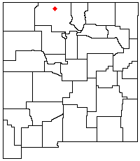
El Vado Lake is a reservoir located in Rio Arriba County, in northern New Mexico in the southwestern United States. Water is impounded by the earth-filled El Vado Dam, on the Rio Chama, 642 feet (196 m) long and 175 feet (53 m) high, completed in 1935. The 3,200-acre (13 km2) lake is 5 miles (8.0 km) long and over 1 mile (1.6 km) wide, and lies at an elevation of 6,900 feet (2,100 m).
The eastern shore of the lake is the El Vado Lake State Park, featuring over 100 camping and picnic sites, and two improved boat ramps. The lake is a destination for salmon and trout fishing, as well as for boating. Unlike nearby Heron Lake, boat speeds are not restricted. A 5.5-mile (8.9 km) hiking trail runs to the north, crosses the Rio Chama Gorge via a pedestrian suspension bridge, and then connects to the Heron Lake State Park.