Clayton, New Mexico
| Clayton, New Mexico | |
|---|---|
| Town | |
|
Main Street (2008) | |
 Location of Clayton within Union County and New Mexico | |
| Coordinates: 36°26′59″N 103°10′51″W / 36.44972°N 103.18083°WCoordinates: 36°26′59″N 103°10′51″W / 36.44972°N 103.18083°W | |
| Country | United States |
| State | New Mexico |
| County | Union |
| Area | |
| • Total | 4.7 sq mi (12.2 km2) |
| • Land | 4.7 sq mi (12.2 km2) |
| • Water | 0.0 sq mi (0.0 km2) |
| Elevation | 5,056 ft (1,541 m) |
| Population (2010)[1] | |
| • Total | 2,980 |
| • Density | 630/sq mi (240/km2) |
| Time zone | Mountain (MST) (UTC-7) |
| • Summer (DST) | MDT (UTC-6) |
| ZIP code | 88415 |
| Area code(s) | 575 |
| FIPS code | 35-15720 |
| GNIS feature ID | 0905193 |
| Website | claytonnm.org |
Clayton is a town and county seat of Union County, New Mexico, United States.[2] As of the 2010 census, the city population was 2,980.[1] Clayton is a crossroads for tourists heading from Texas to Colorado, and Kansas / Oklahoma / Texas to Taos and Santa Fe, New Mexico.
History
.jpg)
Clayton is named for a son of U.S. Senator Stephen W. Dorsey, an Arkansas Republican, originally from Ohio, who served during Reconstruction. The town was established in 1887. Trade caravans and homesteaders traveling through the Cimarron Cutoff of the Santa Fe Trail passed through Clayton. The town was a livestock shipping center for herds from the Pecos River and the Texas Panhandle.[3]
Geography
According to the United States Census Bureau, the town has a total area of 4.7 square miles (12 km2), all land.
Climate
Demographics
| Historical population | |||
|---|---|---|---|
| Census | Pop. | %± | |
| 1910 | 970 | — | |
| 1920 | 2,157 | 122.4% | |
| 1930 | 2,518 | 16.7% | |
| 1940 | 3,188 | 26.6% | |
| 1950 | 3,515 | 10.3% | |
| 1960 | 3,314 | −5.7% | |
| 1970 | 2,931 | −11.6% | |
| 1980 | 2,968 | 1.3% | |
| 1990 | 2,484 | −16.3% | |
| 2000 | 2,524 | 1.6% | |
| 2010 | 2,980 | 18.1% | |
| Est. 2015 | 2,774 | [4] | −6.9% |
As of the census[6] of 2010, there were 2,980 people, 1,025 households (only 77.8% of the population was living in households), and 623 family households residing in the town. The population density was 535.7 people per square mile (206.9/km²). There were 1,289 housing units at an average density of 273.6 per square mile (105.7/km²). The racial makeup of the town was 75.9% White (43.5% non-Hispanic white), 2.7% Native American, 2.6% black or African American, 0.5% Asian, 15.6% from some other races, and 2.6% from two or more races. Hispanic or Latino of any race were 51.1% of the population.
As of the 2000 census, there were 1,079 households out of which 30.5% had children under the age of 18 living with them, 47.6% were married couples living together, 11.7% had a female householder with no husband present, and 35.9% were non-families. 33.7% of all households were made up of individuals and 18.2% had someone living alone who was 65 years of age or older. The average household size was 2.32 and the average family size was 2.99.
In the town, the population was spread out with 27.7% under the age of 18, 6.3% from 18 to 24, 23.8% from 25 to 44, 23.6% from 45 to 64, and 18.7% who were 65 years of age or older. The median age was 40 years. For every 100 females there were 95.7 males. For every 100 females age 18 and over, there were 92.4 males.
The median income for a household in the town was $25,600, and the median income for a family was $30,109. Males had a median income of $26,554 versus $17,054 for females. The per capita income for the town was $13,967. About 14.2% of families and 17.9% of the population were below the poverty line, including 31.4% of those under age 18 and 9.1% of those age 65 or over.
Community
Clayton holds a parade each Independence Day. The community also hosts two museums. The Herzstein Memorial Museum, run by the Union County Historical Society, is open without charge Tuesdays through Saturdays and by appointment. An official interpretative center of the Santa Fe Trail, the Herzstein focuses upon county and regional history.[7] The Works Progress Administration Museum at Clayton High School is open by appointment only. Clayton Lake State Park, featuring a fishing lake and an extensive trackway of fossilized dinosaur footprints, is located 15 miles (24 km) north of town.
See also
Gallery
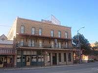 Eklund Hotel (established 1905), 2010.
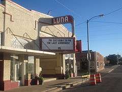 Luna Theater, 2010.
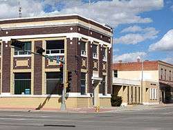
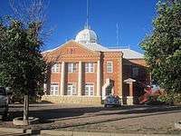 Union County Courthouse, 2010.
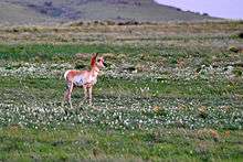
 Rabbit Ears
References
- 1 2 "2010 City Population and Housing Occupancy Status". U.S. Census Bureau. Archived from the original on July 21, 2011. Retrieved December 1, 2011.
- ↑ "Find a County". National Association of Counties. Archived from the original on 2011-05-31. Retrieved 2011-06-07.
- ↑ Historical marker in Clayton, New Mexico
- ↑ "Annual Estimates of the Resident Population for Incorporated Places: April 1, 2010 to July 1, 2015". Retrieved July 2, 2016.
- ↑ "Census of Population and Housing". Census.gov. Archived from the original on May 11, 2015. Retrieved June 4, 2015.
- ↑ "American FactFinder". United States Census Bureau. Archived from the original on 2013-09-11. Retrieved 2008-01-31.
- ↑ Herzstein Memorial Museum
External links
| Wikimedia Commons has media related to Clayton, New Mexico. |
Municipalities and communities of Union County, New Mexico, United States | ||
|---|---|---|
| Town | 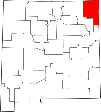 | |
| Villages | ||
| CDP | ||
| Other unincorporated communities | ||