Conway, Pennsylvania
| Conway, Pennsylvania | |
|---|---|
| Borough | |
|
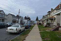
Houses on Second Avenue | |
 Location in Beaver County and state of Pennsylvania | |
| Coordinates: 40°39′48″N 80°14′10″W / 40.66333°N 80.23611°WCoordinates: 40°39′48″N 80°14′10″W / 40.66333°N 80.23611°W | |
| Country | United States |
| State | Pennsylvania |
| County | Beaver |
| Incorporated | 1902 |
| Government | |
| • Type | Borough Council |
| Area | |
| • Total | 1.5 sq mi (4 km2) |
| • Land | 1.2 sq mi (3 km2) |
| • Water | 0.3 sq mi (0.8 km2) |
| Elevation | 909 ft (277 m) |
| Population (2010) | |
| • Total | 2,176 |
| • Density | 1,825.3/sq mi (704.8/km2) |
| Time zone | Eastern (EST) (UTC-5) |
| • Summer (DST) | EDT (UTC-4) |
| Zip code | 15027 |
| Area code(s) | 724 |
Conway is a borough in Beaver County, Pennsylvania, United States, located along the Ohio River. At the 2010 census, the borough had a total population of 2,176.
Geography
Conway is located at 40°39′48″N 80°14′10″W / 40.66333°N 80.23611°W (40.663466, -80.235981).[1]
According to the United States Census Bureau, the borough has a total area of 1.5 square miles (3.9 km2), of which, 1.2 square miles (3.1 km2) of it is land and 0.2 square miles (0.52 km2) of it (13.70%) is water.
Industry
Conway is the site of Conway Yard, a major railroad classification yard and locomotive facility, owned by Norfolk Southern and inherited from Conrail, originally developed by the Pennsylvania Railroad.
Demographics
| Historical population | |||
|---|---|---|---|
| Census | Pop. | %± | |
| 1910 | 1,483 | — | |
| 1920 | 1,858 | 25.3% | |
| 1930 | 2,014 | 8.4% | |
| 1940 | 1,865 | −7.4% | |
| 1950 | 1,570 | −15.8% | |
| 1960 | 1,926 | 22.7% | |
| 1970 | 2,822 | 46.5% | |
| 1980 | 2,747 | −2.7% | |
| 1990 | 2,424 | −11.8% | |
| 2000 | 2,290 | −5.5% | |
| 2010 | 2,176 | −5.0% | |
| Est. 2015 | 2,150 | [2] | −1.2% |
| Sources:[3][4][5] | |||
At the census[4] of 2000, there were 2,290 people, 988 households, and 656 families living in the borough. The population density was 707.3/square kilometre; (1,825.3/square mile). There were 1,026 housing units at an average density of 316.9/square kilometre; (817.8/square mile). The racial makeup of the borough was 98.25% White, 1.27% African American, 0.04% Native American, 0.04% from other races, and 0.39% from two or more races. Hispanic or Latino of any race were 0.48% of the population.
There were 988 households, out of which 23.7% had children under the age of 18 living with them, 53.8% were married couples living together, 8.9% had a female householder with no husband present, and 33.6% were non-families. 31.0% of all households were made up of individuals, and 19.2% had someone living alone who was 65 years of age or older. The average household size was 2.30 and the average family size was 2.87.
In the borough the population was spread out, with 18.7% under the age of 18, 7.1% from 18 to 24, 25.4% from 25 to 44, 25.4% from 45 to 64, and 23.4% who were 65 years of age or older. The median age was 44 years. For every 100 females there were 89.4 males. For every 100 females aged 18 and over, there were 85.4 males.
The median income for a household in the borough was $34,181, and the median income for a family was $46,250. Males had a median income of $36,167 versus $23,516 for females. The per capita income for the borough was $18,699. About 4.8% of families and 7.6% of the population were below the poverty line, including 7.1% of those under the age of 18 and 10.0% of those ages 65 and older.
See also
References
- ↑ "US Gazetteer files: 2010, 2000, and 1990". United States Census Bureau. 2011-02-12. Retrieved 2011-04-23.
- ↑ "Annual Estimates of the Resident Population for Incorporated Places: April 1, 2010 to July 1, 2015". Retrieved July 2, 2016.
- ↑ "Census of Population and Housing". U.S. Census Bureau. Archived from the original on 11 May 2015. Retrieved 11 December 2013.
- 1 2 "American FactFinder". United States Census Bureau. Archived from the original on 2013-09-11. Retrieved 2008-01-31.
- ↑ "Incorporated Places and Minor Civil Divisions Datasets: Subcounty Resident Population Estimates: April 1, 2010 to July 1, 2012". Population Estimates. U.S. Census Bureau. Archived from the original on 17 June 2013. Retrieved 11 December 2013.
External links
| Counties |  Map of the Pittsburgh Tri-State with green counties in the metropolitan area and yellow counties in the combined area. | |
|---|---|---|
| Major cities | ||
| Cities and towns 15k-50k (in 2010) | ||
| Airports | ||
| Topics | ||
| ||
Municipalities and communities of Beaver County, Pennsylvania, United States | ||
|---|---|---|
| Cities | 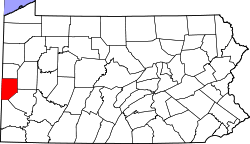 | |
| Boroughs |
| |
| Townships | ||
| Unincorporated communities | ||
| Footnotes | ‡This populated place also has portions in an adjacent county or counties | |