Harmony Township, Beaver County, Pennsylvania
| Harmony Township | |
|---|---|
| Township | |
|
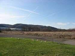
Fields at Legionville, a historic United States Army site in Harmony Township | |
 Location in Beaver County and state of Pennsylvania | |
| Coordinates: 40°36′26″N 80°13′13″W / 40.60722°N 80.22028°WCoordinates: 40°36′26″N 80°13′13″W / 40.60722°N 80.22028°W | |
| Country | United States |
| State | Pennsylvania |
| County | Beaver |
| Settled | 1772 |
| Incorporated | 1851 |
| Area | |
| • Total | 3.1 sq mi (7.9 km2) |
| • Land | 2.9 sq mi (7.5 km2) |
| • Water | 0.2 sq mi (0.4 km2) |
| Population (2010) | |
| • Total | 3,197 |
| • Density | 1,099/sq mi (424.3/km2) |
| Time zone | Eastern (EST) (UTC-5) |
| • Summer (DST) | EDT (UTC-4) |
| Website |
www |
Harmony Township is a township and census-designated place in Beaver County, Pennsylvania, United States. The population was 3,197 at the 2010 census.[1]
Geography
Harmony Township is located in southeastern Beaver County at 40°36′25″N 80°13′13″W / 40.60694°N 80.22028°W (40.607217, -80.220321).[2] It is bordered to the southwest by the borough of Ambridge, to the west (across the Ohio River) by the city of Aliquippa, to the north by the borough of Baden, and to the east by the borough of Economy. The southeast boundary of the township, formed by Big Sewickley Creek, is also the Beaver County line. To the southeast in Allegheny County are the borough of Bell Acres, Leet Township, and the borough of Leetsdale.
According to the United States Census Bureau, Harmony Township has a total area of 3.1 square miles (7.9 km2), of which 2.9 square miles (7.5 km2) is land and 0.15 square miles (0.4 km2), or 5.21%, is water.[1]
Demographics
As of the census[3] of 2000, there were 3,373 people, 1,439 households, and 991 families residing in the township. The population density was 1,176.3 people per square mile (453.8/km²). There were 1,509 housing units at an average density of 526.2/sq mi (203.0/km²). The racial makeup of the township was 97.48% White, 1.45% Black or African American, 0.12% Asian, 0.12% Pacific Islander, 0.21% from other races, and 0.62% from two or more races. Hispanic or Latino of any race were 0.56% of the population.
There were 1,439 households, out of which 23.7% had children under the age of 18 living with them, 55.9% were married couples living together, 9.2% had a female householder with no husband present, and 31.1% were non-families. 28.2% of all households were made up of individuals, and 19.2% had someone living alone who was 65 years of age or older. The average household size was 2.33 and the average family size was 2.84.
In the township the population was spread out, with 19.1% under the age of 18, 5.3% from 18 to 24, 26.9% from 25 to 44, 21.8% from 45 to 64, and 26.8% who were 65 years of age or older. The median age was 44 years. For every 100 females there were 90.8 males. For every 100 females age 18 and over, there were 87.7 males.
The median income for a household in the township was $37,056, and the median income for a family was $48,824. Males had a median income of $35,682 versus $24,464 for females. The per capita income for the township was $18,663. About 2.6% of families and 4.7% of the population were below the poverty line, including 4.0% of those under age 18 and 3.9% of those age 65 or over.
References
- 1 2 "Geographic Identifiers: 2010 Demographic Profile Data (G001): Harmony township, Beaver County, Pennsylvania". U.S. Census Bureau, American Factfinder. Retrieved February 27, 2014.
- ↑ "US Gazetteer files: 2010, 2000, and 1990". United States Census Bureau. 2011-02-12. Retrieved 2011-04-23.
- ↑ "American FactFinder". United States Census Bureau. Retrieved 2008-01-31.
External links
Municipalities and communities of Beaver County, Pennsylvania, United States | ||
|---|---|---|
| Cities | 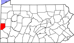 | |
| Boroughs |
| |
| Townships | ||
| Unincorporated communities | ||
| Footnotes | ‡This populated place also has portions in an adjacent county or counties | |
| Counties |  Map of the Pittsburgh Tri-State with green counties in the metropolitan area and yellow counties in the combined area. | |
|---|---|---|
| Major cities | ||
| Cities and towns 15k-50k (in 2010) | ||
| Airports | ||
| Topics | ||
| ||