Corinda, Queensland
| Corinda Brisbane, Queensland | |||||||||||||
|---|---|---|---|---|---|---|---|---|---|---|---|---|---|
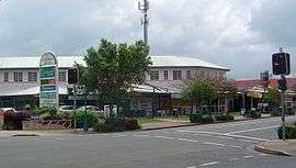 Shops along Oxley Road | |||||||||||||
| Coordinates | 27°32′S 152°59′E / 27.533°S 152.983°ECoordinates: 27°32′S 152°59′E / 27.533°S 152.983°E | ||||||||||||
| Population | 4,695 (2011 census)[1] | ||||||||||||
| Postcode(s) | 4075 | ||||||||||||
| Location | 9 km (6 mi) from Brisbane GPO | ||||||||||||
| LGA(s) | City of Brisbane | ||||||||||||
| State electorate(s) | Mount Ommaney | ||||||||||||
| Federal Division(s) | Oxley | ||||||||||||
| |||||||||||||
Corinda is a suburb in Brisbane, Australia, located approximately 8.8 kilometres (5.5 mi) southwest of the Brisbane central business district. At the 2011 Australian Census the suburb recorded a population of 4,695.[1]
It is believed that the name Corinda originates from a local cattle station owned by Sir Arthur Palmer, which he named after his Corinda pastoral station near Aramac.
Demographics
In the 2011 census, the population of Corinda was 4,695, consisting of 52.3% female and 47.7% male. The median age of the Corinda population was 39 years, two years above the Australian median. 71.8% of people living in Corinda were born in Australia, similar to the national average of 69.8%. The other top responses for country of birth were England 4.9%, New Zealand 2.9%, India 1.1%, Philippines 0.8%, Germany 0.7%. 82.9% of people speak only English at home, while other languages include 0.9% Vietnamese, 0.8% Spanish, 0.8% Mandarin, 0.6% Cantonese, 0.6% Arabic.[1]
History
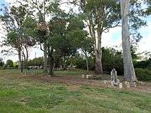
Corinda was first settled in the 1860s as a small farming community. Among the original settlers was the Francis family who in 1862 purchased 21 acres, which extended from the Brisbane River to Francis Lookout, a local heritage listed[2] landmark on Dewar Terrace. Francis Lookout survives to this day, and includes a small burial ground opened in 1862.[3] Its ten graves include those of some of the pioneer settlers. The oldest of the graves is of Clement Francis who died in 1863. The lychgate, erected by Angela Francis, dates to 1902. Most of the original older-style Queenslander homes date back to the colonial period and were built high on the hills around the lookout.
The first rail line opened in 1874. A small commercial district on Oxley Road gradually grew around it. The Corinda School of Arts (now municipal library) is one of the earliest surviving buildings on this strip and is a small timber structure built in 1895. The commercial district rapidly developed after the 1920s. Many large bungalow styled homes were built on the floodplain toward Oxley Creek during this time.
The Corinda RSL was established in 1964 and now trades as the Sherwood Services Club.[4] With the opening of Coles Supermarkets, the commercial centre has continued to develop and extend westward.
The suburb experienced a landslip during the 1974 Brisbane flood which affected more than 20 houses.
Heritage listings
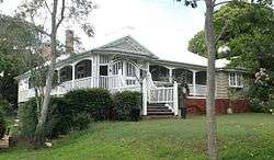
Corinda has a number of heritage-listed sites, including:
Open space
Corinda has two main parks both sharing the same name but separated at either end of the suburb. One is a forest reserve along the Brisbane River which includes Carrington Rocks and Carrington Boat Club. The other is on the floodplain of Oxley Creek near the bowls club and state school. The historic Francis Lookout reserve has another small park used for the traditional local Carols by Candlelight celebrations run by various local church and school groups. The Sherwood Arboretum borders the suburb but is located in Sherwood.
Places of worship
- Christ Community Church West, Cliveden Avenue
- St John’s Lutheran Church, cnr Oxley Rd and Clewley Street
- St Joseph's Catholic Church, cnr Oxley Rd and Martindale Street
Transport
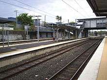
The Corinda railway station provides residents with easy access to the Brisbane CBD, servicing many suburbs and providing access to many popular entertainment and educational venues along the way, including the Indooroopilly Shopping Centre and the University of Queensland. As a result of changes to transport planning in July 2011, there is also a less frequent bus service (Bus 104) to Tennyson railway station.
Education
There are two private schools in Corinda - St Aidan's Anglican Girls School (Prep to Year 12) near the railway station, and St Joseph's Catholic School (Prep to Year 7) near the Corinda Village Shopping Centre. The public primary schools (Corinda State Primary School) established in 1927 and high school (Corinda State High School) established in 1960 are towards the southern end of Corinda.
Natural hazards
As the suburb is bounded by the Brisbane River and Oxley Creek, parts of the suburb are susceptible, in extreme circumstances, to flooding. Parts of the suburb are also susceptible to landslip, as demonstrated in the 1974 Corinda Landslip.
References
- 1 2 3 Australian Bureau of Statistics (31 October 2012). "Corinda (State Suburb)". 2011 Census QuickStats. Retrieved 16 February 2013.
- ↑ "Francis Lookout (entry 602441)". Queensland Heritage Register. Queensland Heritage Council. Retrieved 13 July 2015.
- ↑ Francis Lookout burial ground, Corinda, Brisbane. Retrieved 13 February 2011.
- ↑ Sherwood Club History. Services Club. Retrieved 13 February 2011.
- ↑ "Monkton (entry 601170)". Queensland Heritage Register. Queensland Heritage Council. Retrieved 6 July 2013.
- ↑ "Francis Lookout (entry 602441)". Queensland Heritage Register. Queensland Heritage Council. Retrieved 6 July 2013.
- ↑ "Weemalla (entry 602820)". Queensland Heritage Register. Queensland Heritage Council. Retrieved 23 December 2014.
External links
| Wikimedia Commons has media related to Corinda, Queensland. |
- University of Queensland: Queensland Places: Corinda
- "Corinda". BRISbites. Brisbane City Council. Archived from the original on 19 July 2008.
- "Corinda". Our Brisbane. Brisbane City Council. Archived from the original on 22 December 2007.