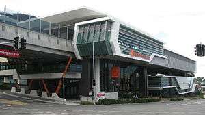
Herston, Queensland
| Herston Brisbane, Queensland | |||||||||||||
|---|---|---|---|---|---|---|---|---|---|---|---|---|---|
| Population | 1,831 (2011 census)[1] | ||||||||||||
| • Density | 1,080/km2 (2,790/sq mi) | ||||||||||||
| Postcode(s) | 4006 | ||||||||||||
| Area | 1.7 km2 (0.7 sq mi) | ||||||||||||
| Location | 3 km (2 mi) from Brisbane | ||||||||||||
| LGA(s) | City of Brisbane | ||||||||||||
| State electorate(s) | Brisbane Central | ||||||||||||
| Federal Division(s) | Brisbane | ||||||||||||
| |||||||||||||
Herston is an inner suburb of Brisbane, Australia located 3 kilometres (1.9 mi) north of the Brisbane CBD.
Geography
Herston is dominated by the Royal Brisbane and Women's Hospital. The hospital campus is also shared by the Queensland Institute of Medical Research and the former Royal Children's Hospital.
Herston is mostly a residential suburb, with some areas of light industry near the main roads. Many of Herston's residents are employed by the hospital or nearby at the Queensland University of Technology in Kelvin Grove. There is also a significant student population that studies at the university.
Demographics
In the 2011 census, Herston recorded a population of 1,831 people, 50.2% female and 49.8% male.
The median age of the Herston population was 29 years of age, 8 years below the Australian median.
67.4% of people living in Herston were born in Australia, compared to the national average of 69.8%; the next most common countries of birth were China 4.2%, England 3.3%, India 2.3%, New Zealand 2.2%, Vietnam 1%.
75.5% of people spoke only English at home; the next most common languages were 4.6% Mandarin, 1.2% Spanish, 1.1% Malayalam, 1.1% Cantonese, 1% French.
Transport
Prior to December 1968 the eastern side of the suburb was served by frequent tram services along Bowen Bridge Road, with routes converging from Chermside, Kalinga (until 1962), Stafford, and Grange. These services combined to provide the suburb with an off-peak service of a tram every 2½ minutes along Bowen Bridge Road in the late 1950s. The western side of the suburb was served by trams which ran along Kelvin Grove Road. This service also ceased in December 1968.
Between 1953 and November 1968, the suburb was also served by Brisbane City Council trolley-buses which connected the suburb with Fortitude Valley and ran through to Stanley Bridge in East Brisbane. The trolley-buses ran along Herston Road and Butterfield Street, past Ballymore football ground, terminating near the intersection of Prospect Terrace and Kelvin Grove Road.
Brisbane City Council diesel buses continue to serve the suburb. The Inner-Northern Busway runs through the south of the suburb, having been built to divert buses off congested major roads.
History
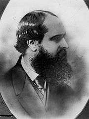

Herston was first settled by Europeans in the 1850s. Sir Robert Herbert, Queensland's first premier, built a farm in the area, and lived in the farmhouse with his then Attorney-General, John Bramston. The pair named their house Herston, a combination of their surnames, which eventually became the name of the suburb.[2][3]
Many of Herston's streets were named after local identities of the time. Bowen Bridge Road and Bowen Park were named after Sir George Bowen, Queensland's first governor. Butterfield Street was named after local schoolmaster William Butterfield. Hetherington Street was named after coal industry identity John William Hetherington, and Garrick Terrace got its name from James Francis Garrick, the man who purchased Herston from Herbert and Bramston.[4]
Heritage listings
Herston has a number of heritage-listed sites, including:
- 40 Bowen Bridge Road: Brisbane General Hospital Precinct[5]
- Herston Road: Royal Brisbane Hospital Nurses' Homes[6]
- 288 Herston Road: University of Queensland Mayne Medical School[7]
- 309 Herston Road: former Victoria Park Golf Clubhouse[8]
See also
References
- ↑ Australian Bureau of Statistics (31 October 2012). "Herston (State Suburb)". 2011 Census QuickStats. Retrieved 25 October 2013.
- ↑ "LINKS WITH THE LONG AGO.". The Queenslander (Brisbane, Qld. : 1866 - 1939). Brisbane, Qld.: National Library of Australia. 11 September 1930. p. 7. Retrieved 25 January 2013.
- ↑ Aldrich, Robert; Wotherspoon, Garry (2001). Who's Who in Contemporary Gay and Lesbian History: From World War II to the Present Day. Routledge. p. 207. ISBN 0-415-15982-2. Retrieved 1 March 2008.
- ↑ Smith, Phil (24 February 2006). "Local History - Herston". Brisbane: Australian Broadcasting Corporation. Retrieved 1 March 2008.
- ↑ "Brisbane General Hospital Precinct (entry 601903)". Queensland Heritage Register. Queensland Heritage Council. Retrieved 6 July 2013.
- ↑ "Nurses' Homes, Royal Brisbane Hospital (including Lady Lamington and Blocks 1 and 2) (entry 600223)". Queensland Heritage Register. Queensland Heritage Council. Retrieved 6 July 2013.
- ↑ "University of Queensland Medical School (entry 601167)". Queensland Heritage Register. Queensland Heritage Council. Retrieved 6 July 2013.
- ↑ "Victoria Park Golf Clubhouse (former) (entry 602034)". Queensland Heritage Register. Queensland Heritage Council. Retrieved 6 July 2013.
External links
![]() Media related to Herston, Queensland at Wikimedia Commons
Media related to Herston, Queensland at Wikimedia Commons
Coordinates: 27°26′53″S 153°01′23″E / 27.448°S 153.023°E