Norman Park, Queensland
| Norman Park Brisbane, Queensland | |||||||||||||
|---|---|---|---|---|---|---|---|---|---|---|---|---|---|
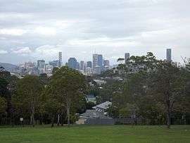 Brisbane central business district seen from Norman Park | |||||||||||||
| Population | 6,003 (2011 census)[1] | ||||||||||||
| Postcode(s) | 4170[2] | ||||||||||||
| Location | 4 km (2 mi) E of Brisbane CBD[3] | ||||||||||||
| LGA(s) | City of Brisbane | ||||||||||||
| State electorate(s) | Bulimba | ||||||||||||
| Federal Division(s) | Griffith | ||||||||||||
| |||||||||||||
Norman Park is a suburb of Brisbane, Australia, located 4 kilometres (2.5 mi) east of the CBD.[3] It borders East Brisbane, Coorparoo, Camp Hill, Morningside and Hawthorne, and is mostly residential.[4]
Toponymy
Norman Park is likely named after an early estate in the area. The estate is thought to have derived its name in the 1890s from the nearby Norman Creek, and the contemporary Governor of Queensland Henry Wylie Norman.[4][5]
History
Norman Park began taking in the first settlers in 1853. Initially, development in Norman Park was slow and almost ceased after the 1893 Brisbane floods. Industries in Norman Park at the time included dairying, leather and brooms.
Between 1912 and 1926 a steam tram service to Belmont connected with the Queensland Government Railway at Norman Park. Initially the service was operated by the Belmont Shire Council. The service was suspended in 1924. The service was reinstated by the Brisbane City Council in 1925, but was again suspended in 1926. In 2006 remnants of the tramway's right of way could still be seen close to the railway station.
Norman Park remained a largely rural area until after World War II, when rapid development took place as the result of the construction of public housing.[4] In the 1940s and 1950s, extensive reclaiming of land in the low-lying areas created parks and playing fields.
Demographics
The 2011 Census recorded 6,003 residents in Norman Park, of whom 50.7% were female and 49.3% were male. The median age of the population was 33; four years younger than the Australian median.[1]
77.2% of people living in Norman Park were born in Australia, compared to the national average of 69.8%. The other most common countries of birth were England (3.8%), New Zealand (3.4%), South Africa (0.8%), Germany (0.7%), and Ireland (0.7%). 87.4% of people only spoke English at home, while the next most commonly spoken languages were Greek (0.8%), German (0.6%), French (0.5%), Italian (0.5%), and Japanese (0.4%).
Public Transport
Three radial bus corridors pass through the suburb. The Wynnum Road corridor in the suburb's north is serviced by three bus routes that travel between the Brisbane central business district and eastern suburbs. These routes when combined offer frequent service with a long span, particularly on weekdays. The Stanley Street East-Canara Street-Crown Street-Bennetts Road corridor through the centre of the suburb is serviced by one all-stops bus route that travels between the Brisbane central business district and Carindale Shopping Centre bus station. This route has limited frequency and span. This corridor is also serviced by two alternating express bus routes between the Brisbane central business district and Cannon Hill Shopping Centre bus station and eastern suburbs, observing Norman Park and Norman Park North express stops. These two routes when combined provide frequent service with a relatively long span. The Stanley Street East-Milsom Street-McIlwraith Avenue corridor in the suburb's south is serviced by one all-stops route that travels between the Brisbane central business district and Cannon Hill Shopping Centre bus station. This route has limited frequency and span, but is supplemented during peak periods by a limited stops route that runs express along Stanley Street East.
The Cleveland railway line passes through the suburb, with Norman Park station located centrally. Trains operate at a 15-minute off-peak frequency and higher peak period frequency during weekdays, and a lower 30 minute frequency on weekends. This line has a long service span.
Norman Park Ferry Terminal is located off Wynnum Road in the suburb's north. The cross-river Norman Park Ferry provides direct access to New Farm Ferry Terminal, which is then serviced by the CityCat linear ferry line between Northshore Hamilton and The University of Queensland via the Brisbane central business district.
Despite the suburb being well serviced by three modes of public transport, no formal coordination exists between them aside from the TransLink (South East Queensland) fare structure and relatively high frequency standards. The suburb is situated within TransLink Zone 2, which makes it attractive to city commuters with respect to relatively cost effective transit travel.
Walking and Cycling
The suburb's terrain varies from flat on the Norman Creek floodplain in the suburb's south and west towards Coorparoo and East Brisbane, to hilly in the suburb's north towards Hawthorne and Morningside, and east towards Seven Hills and Camp Hill. Traffic conditions are busy along its major roads including Canara Street-Crown Street-Macrossan Avenue, Bennetts Road, and Wynnum Road. Recreational cycling opportunities are consequently limited on the north and east sides of the suburb. However, the presence of parkland between Norman Avenue and Norman Creek including the Norman Creek Cycleway provides for good opportunities on its south and west sides. As at February 2016 several city-wide cycle routes pass through the suburb. This includes Wynnum Road, which has a shared pedestrian/bicycle path due to narrow traffic lanes, Canara Street-Crown Street-Macrossan Avenue, which is line-marked as a Bicycle Awareness Zone (yellow stencil stylized bicycle marked on edge of vehicle travel lane), and Bennetts Road, which has formal bicycle lanes south of Agnew Street. Packs of cyclists are commonplace along these routes early on weekend mornings.
The hilly terrain in the suburb's north and east sides, busy traffic conditions and bisection by the Cleveland railway line also impose some impediment to local walking opportunities. However, the semi-grid structure of the road and street network and the presence of urban borders (verges) on almost all roadways promote relatively direct and safe walking conditions. The higher order local streets and the major roads mostly have paved footpaths on one or both sides. The major roads contain numerous signalised intersections with pedestrian control, which are typically located adjacent to bus stops. Refuge islands support safe crossing of certain other roads and streets. In addition to local pocket parks, nearby recreational walking attractions include parkland and sporting fields along both banks of Norman Creek, rugby fields at C.P. Bottomley Park, Norman Park Ferry Terminal and Canning Bridge reserves on the south bank of the Brisbane River, and Balmoral Park in Morningside. Seven Hills Bushland Reserve is also located within walking distance of the eastern side of Norman Park.
Heritage listings
Norman Park has a number of heritage-listed sites, including:
- 75 McIllwraith Avenue: Eulalia[6]
- 97 Wynnum Road: former Brisbane City Council Tramways Substation No 9[7]
Notable people
- Kevin Rudd, former Australian prime minister, lives in Norman Park.[8]
References
- 1 2 Australian Bureau of Statistics (31 October 2012). "Norman Park, Qld (State Suburb)". 2011 Census QuickStats. Retrieved 12 October 2013.
- ↑ "Find a postcode". Australia Post. Retrieved 11 January 2014.
- 1 2 Centre for the Government of Queensland. "Norman Park". Retrieved 15 October 2014.
- 1 2 3 "Norman Park". Australian Bureau of Statistics. Retrieved 11 January 2014.
- ↑ "Queensland place name search". Government of Queensland (Department of Natural Resources and Mines). Retrieved 15 October 2014.
- ↑ "Eulalia (entry 600269)". Queensland Heritage Register. Queensland Heritage Council. Retrieved 6 July 2013.
- ↑ "Brisbane City Council Tramway Substation No 9 (former) (entry 602410)". Queensland Heritage Register. Queensland Heritage Council. Retrieved 6 July 2013.
- ↑ "Kevin Rudd once again running the nation from his back deck in Brisbane's Norman Park". Courier Mail. Retrieved 4 August 2013.
External links
![]() Media related to Norman Park, Queensland at Wikimedia Commons
Media related to Norman Park, Queensland at Wikimedia Commons
Coordinates: 27°28′45″S 153°03′45″E / 27.479168°S 153.0625°E