Cottonwood, Colorado
| Cottonwood, Colorado | |
|---|---|
| Former Census-designated place (CDP); Unincorporated community | |
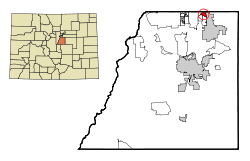 Location in Douglas County and the State of Colorado | |
| Coordinates: 39°33′34″N 104°48′2″W / 39.55944°N 104.80056°WCoordinates: 39°33′34″N 104°48′2″W / 39.55944°N 104.80056°W | |
| Country |
|
| State |
|
| County | Douglas County |
| Government | |
| • Type | Former Census-designated place (CDP) |
| Area | |
| • Total | 0.9 sq mi (2.3 km2) |
| • Land | 0.9 sq mi (2.3 km2) |
| • Water | 0 sq mi (0 km2) |
| Elevation[1] | 5,751 ft (1,753 m) |
| Population (2000) | |
| • Total | 931 |
| • Density | 1,034.4/sq mi (404.8/km2) |
| Time zone | MST (UTC-7) |
| • Summer (DST) | MDT (UTC-6) |
| Area code(s) | 303, 720 |
| FIPS code | 08-17492 |
| GNIS feature ID | 1852842 |
Cottonwood was a census-designated place (CDP) and unincorporated community in Douglas County, Colorado, United States. The population was 931 at the 2000 census. Cottonwood did not appear in the 2010 census,[2] as most of it had been incorporated into the neighboring town of Parker.
Geography
Cottonwood is located at 39°33′34″N 104°48′2″W / 39.55944°N 104.80056°W (39.559498, -104.800579).[3]
According to the United States Census Bureau, the CDP had a total area of 0.9 square miles (2.3 km2), all of it land.
Climate
This climate type is usually found in the outskirts of true deserts in low-latitude, semiarid regions. It has a cooler, wetter winter resulting from the higher latitude and mid-latitude frontal cyclone activity. Annual precipitation totals are greater than in tropical and subtropical desert climates. Yearly variations in amount are not as extreme as in the true deserts but are nevertheless large. The Köppen Climate Classification subtype for this climate is "BSk". (Tropical and Subtropical Steppe Climate).
| Climate data for Cottonwood, Colorado | |||||||||||||
|---|---|---|---|---|---|---|---|---|---|---|---|---|---|
| Month | Jan | Feb | Mar | Apr | May | Jun | Jul | Aug | Sep | Oct | Nov | Dec | Year |
| Average high °C (°F) | 6 (43) |
8 (46) |
11 (51) |
16 (60) |
21 (69) |
27 (80) |
30 (86) |
29 (84) |
25 (77) |
19 (66) |
11 (52) |
7 (45) |
17 (63) |
| Average low °C (°F) | −9 (15) |
−8 (18) |
−5 (23) |
−1 (31) |
4 (40) |
9 (49) |
13 (55) |
12 (54) |
8 (46) |
2 (35) |
−5 (23) |
−8 (17) |
1 (34) |
| Average precipitation mm (inches) | 8 (0.3) |
8 (0.3) |
23 (0.9) |
33 (1.3) |
64 (2.5) |
48 (1.9) |
56 (2.2) |
48 (1.9) |
28 (1.1) |
20 (0.8) |
18 (0.7) |
8 (0.3) |
358 (14.1) |
| Source: Weatherbase [4] | |||||||||||||
Demographics
As of the census[5] of 2000, there were 931 people, 336 households, and 271 families residing in the CDP. The population density was 1,056.4 people per square mile (408.5/km²). There were 340 housing units at an average density of 385.8 per square mile (149.2/km²). The racial makeup of the CDP was 91.73% White, 1.18% African American, 0.86% Native American, 1.07% Asian, 0.11% Pacific Islander, 3.33% from other races, and 1.72% from two or more races. Hispanic or Latino of any race were 6.66% of the population.
There were 336 households out of which 50.3% had children under the age of 18 living with them, 70.5% were married couples living together, 7.1% had a female householder with no husband present, and 19.3% were non-families. 13.4% of all households were made up of individuals and 0.3% had someone living alone who was 65 years of age or older. The average household size was 2.77 and the average family size was 3.04.
In the CDP the population was spread out with 31.3% under the age of 18, 4.1% from 18 to 24, 58.3% from 25 to 44, 5.6% from 45 to 64, and 0.8% who were 65 years of age or older. The median age was 29 years. For every 100 females there were 105.5 males. For every 100 females age 18 and over, there were 100.6 males.
The median income for a household in the CDP was $64,013, and the median income for a family was $64,605. Males had a median income of $51,693 versus $30,500 for females. The per capita income for the CDP was $23,179. None of the population or families were below the poverty line.
See also
- Outline of Colorado
- State of Colorado
References
- ↑ "US Board on Geographic Names". United States Geological Survey. 2007-10-25. Retrieved 2008-01-31.
- ↑ Colorado Trend Report 2: State and Complete Places (Sub-state 2010 Census Data). Missouri Census Data Center. Accessed 2011-02-25.
- ↑ "US Gazetteer files: 2010, 2000, and 1990". United States Census Bureau. 2011-02-12. Retrieved 2011-04-23.
- ↑ http://www.weatherbase.com/weather/weather.php3?s=623650&cityname=Parker-Colorado (closest city on record to Cottonwood, Colorado) "Weatherbase.com" Check
|url=value (help). Weatherbase. 2013. Retrieved on May 5, 2013. - ↑ "American FactFinder". United States Census Bureau. Archived from the original on 2013-09-11. Retrieved 2008-01-31.
External links
Municipalities and communities of Douglas County, Colorado, United States | ||
|---|---|---|
| Cities | 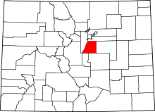 | |
| Towns | ||
| CDPs | ||
| Unincorporated communities | ||
| Footnotes | ‡This populated place also has portions in an adjacent county or counties | |