Roxborough Park, Colorado
| Roxborough Park, Colorado | |
|---|---|
| Census-designated place | |
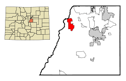 Location in Douglas County and the state of Colorado | |
| Coordinates: 39°27′33″N 105°4′43″W / 39.45917°N 105.07861°WCoordinates: 39°27′33″N 105°4′43″W / 39.45917°N 105.07861°W | |
| Country |
|
| State |
|
| County | Douglas County[1] |
| Government | |
| • Type | unincorporated community |
| Area | |
| • Total | 9.3 sq mi (24.2 km2) |
| • Land | 9.2 sq mi (23.9 km2) |
| • Water | 0.1 sq mi (0.3 km2) |
| Elevation[1] | 5,751 ft (1,753 m) |
| Population (2010) | |
| • Total | 9,099 |
| • Density | 985/sq mi (380.5/km2) |
| Time zone | Mountain (MST) (UTC-7) |
| • Summer (DST) | MDT (UTC-6) |
| ZIP code | 80125 |
| FIPS code | 08-66197 |
| GNIS feature ID | 1852848 |
Roxborough Park is a census-designated place (CDP) in Douglas County, Colorado, United States. The population was 9,099 at the 2010 census,[2] up from 4,446 at the 2000 census.
Geography
Roxborough Park is located in northwestern Douglas County at 39°27′33″N 105°4′43″W / 39.45917°N 105.07861°W (39.459235, -105.078524).[3] It sits at the foot of the Front Range of the Rocky Mountains. The Dakota Hogback, a prominent sandstone ridge, runs north-south through the community. The CDP is bordered to the west by Pike National Forest, and Roxborough State Park, known for its dramatic sandstone formations, is on the southern edge of the community. Downtown Denver is 25 miles (40 km) to the northeast.
According to the United States Census Bureau, the CDP has a total area of 9.3 square miles (24.2 km2), of which 9.2 square miles (23.9 km2) is land and 0.1 square miles (0.3 km2), or 1.35%, is water.[2]
Demographics
As of the census[4] of 2000, there were 4,446 people, 1,587 households, and 1,328 families residing in the CDP. The population density was 457.9 people per square mile (176.8/km²). There were 1,637 housing units at an average density of 168.6 per square mile (65.1/km²). The racial makeup of the CDP was 93.88% White, 0.47% African American, 0.47% Native American, 1.42% Asian, 0.09% Pacific Islander, 1.71% from other races, and 1.96% from two or more races. Hispanic or Latino of any race were 5.58% of the population.
There were 1,587 households out of which 43.9% had children under the age of 18 living with them, 77.1% were married couples living together, 4.2% had a female householder with no husband present, and 16.3% were non-families. 10.3% of all households were made up of individuals and 0.8% had someone living alone who was 65 years of age or older. The average household size was 2.80 and the average family size was 3.03.
In the CDP the population was spread out with 29.4% under the age of 18, 4.0% from 18 to 24, 41.9% from 25 to 44, 21.8% from 45 to 64, and 2.9% who were 65 years of age or older. The median age was 34 years. For every 100 females there were 104.6 males. For every 100 females age 18 and over, there were 103.5 males.
The median income for a household in the CDP was $78,607, and the median income for a family was $81,281. Males had a median income of $51,543 versus $35,968 for females. The per capita income for the CDP was $36,300. About 2.0% of families and 1.7% of the population were below the poverty line, including 1.2% of those under age 18 and none of those age 65 or over.
Places of interest
Roxborough is situated next to Pike National Forest, two state parks and an abundance of recreational opportunities. It is also host to historical and archaeological sites. Roxborough State Park is to the south, with abundant wildlife, red rock formations and connections to multiple trail systems. Chatfield State Park is slightly farther to the north, with boating, fishing, camping, horseback riding, an off-leash dog park, remote-control flying field and an extensive trail system. Waterton Canyon (on the South Platte River) and the High Line Canal are owned by Denver Water and offer a beautiful road and trail system for hikers, runners, cyclists and equestrians.
In 1960, while digging a pond, Charles Lamb discovered Columbian mammoth remains on what is now Lamb Springs, the site of one of the largest collection of mammoth bones in the state.
Arrowhead Golf Club is one of the most scenic golf courses in the Greater Denver area, and a popular venue for weddings and events.
- Arrowhead Golf Club
- Chatfield State Park
- High Line Canal
- Lamb Springs Archaeological Preserve
- Roxborough State Park
- Waterton Canyon
See also
- Outline of Colorado
- State of Colorado
References
- 1 2 "US Board on Geographic Names". United States Geological Survey. 2007-10-25. Retrieved 2008-01-31.
- 1 2 "Geographic Identifiers: 2010 Demographic Profile Data (G001): Roxborough Park CDP, Colorado". U.S. Census Bureau, American Factfinder. Retrieved October 19, 2015.
- ↑ "US Gazetteer files: 2010, 2000, and 1990". United States Census Bureau. 2011-02-12. Retrieved 2011-04-23.
- ↑ "American FactFinder". United States Census Bureau. Retrieved 2008-01-31.
External links
Municipalities and communities of Douglas County, Colorado, United States | ||
|---|---|---|
| Cities | 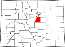 | |
| Towns | ||
| CDPs | ||
| Unincorporated communities | ||
| Footnotes | ‡This populated place also has portions in an adjacent county or counties | |