Crawford Notch
| Crawford Notch | |
|---|---|
|
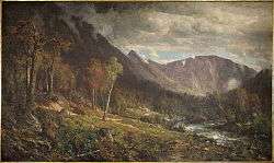
The Notch of the White Mountains (1839), by Thomas Cole (1801–1848), looking south | |
| Traversed by |
|
| Location | Carroll / Coos counties, New Hampshire, U.S. |
| Range | White Mountains |
| Coordinates | 44°12.5′N 71°24.3′W / 44.2083°N 71.4050°WCoordinates: 44°12.5′N 71°24.3′W / 44.2083°N 71.4050°W |
| Topo map | USGS Crawford Notch, Stairs Mountain, Bartlett |
-1839-Thomas_Cole.jpg)
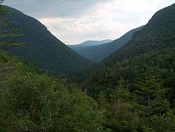
Crawford Notch is the steep and narrow gorge of the Saco River in the White Mountains of New Hampshire, located almost entirely within the town of Hart's Location. Roughly half of that town is contained in Crawford Notch State Park.
The notch is at the upper or northern end of this gorge (constituting the extreme southern end of a panhandle at the southeastern corner of the town of Carroll), where the land descends both to north and south, and ascends both to east and west. However, the steepness of the south-flowing Saco's gorge (in contrast to the leisurely descent of the northward drainage into the watershed of Crawford Brook and eventually the Ammonoosuc River) makes it natural to attach the name to the gorge.
The gorge (like Hart's Location) is bisected by U.S. Highway 302 and the Saco, which run very similar courses.
History
The notch became known to European settlers when found by Timothy Nash in 1771. The 1772 boundaries of Hart's Grant reflected its shape. It was named for Abel Crawford, an explorer, trail-builder and hosteler in the early 19th century. The Tenth New Hampshire Turnpike from Portsmouth was extended through the notch to Lancaster in 1803. The turnpike and later Portland and Ogdensburg Railroad through Crawford Notch opened a new route through the White Mountains for settlers of the area to the northwest to reach Conway on the way to the trading ports on the coast.[1]
A well-documented historic event within the notch was a rock-slide that killed the entire Samuel Willey family in August, 1826. The family fled their home during the storm to a prepared shelter but were buried by the slide and died in a mass of stone and rubble. Their home was untouched. Mount Willey, on the west side of the notch, is named in their memory. Further down the notch, Nancy Brook and Mount Nancy are named for an earlier tragedy.
In the Carroll portion of the notch, the Appalachian Mountain Club has built and operates the Highland Center Lodge and Conference Center, and has renovated the Queen Anne style Victorian-era Crawford Notch Maine Central train depot as a bookstore. The depot remains a stop on the scenic "Notch Train" of the Conway Scenic Railroad, operated seasonally from North Conway.
Points of interest
- Grave of Samuel Bemis, first photographer of the American landscape
- Mount Willard, open summit near center of notch with outstanding views of the notch's structure
See also
- Crawford Notch State Park
- List of mountain passes in New Hampshire
- Nash & Sawyer Location, New Hampshire
- NH Historical Marker #30, The Crawford Family
Notes
- ↑ Johnson, Ron Maine Central Railroad Mountain Division p.9
References
- Julyan, Robert and Mary (1993). Place Names of the White Mountains (revised ed.). Hanover: University Press of New England. ISBN 0-87451-638-2.
External links
- NH State Parks web page
- The Willey Family Catastrophe in the White Mountains of New Hampshire in August 1826
- 19th century landscape paintings of Crawford Notch
- Highland Center Lodge at Crawford Notch