Stow, Maine
| Stow, Maine | |
|---|---|
| Town | |
|
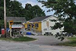
The Corner Store | |
 Stow, Maine Location within the state of Maine | |
| Coordinates: 44°11′55″N 70°58′30″W / 44.19861°N 70.97500°W | |
| Country | United States |
| State | Maine |
| County | Oxford |
| Area[1] | |
| • Total | 24.34 sq mi (63.04 km2) |
| • Land | 24.21 sq mi (62.70 km2) |
| • Water | 0.13 sq mi (0.34 km2) |
| Elevation | 614 ft (187 m) |
| Population (2010)[2] | |
| • Total | 385 |
| • Estimate (2012[3]) | 399 |
| • Density | 15.9/sq mi (6.1/km2) |
| Time zone | Eastern (EST) (UTC-5) |
| • Summer (DST) | EDT (UTC-4) |
| ZIP code | 04037 |
| Area code(s) | 207 |
| FIPS code | 23-74685 |
| GNIS feature ID | 0582752 |
Stow is a town in Oxford County, Maine, United States. The population was 385 at the 2010 census.
Geography
According to the United States Census Bureau, the town has a total area of 24.34 square miles (63.04 km2), of which, 24.21 square miles (62.70 km2) of it is land and 0.13 square miles (0.34 km2) is water.[1]
Demographics
| Historical population | |||
|---|---|---|---|
| Census | Pop. | %± | |
| 1820 | 129 | — | |
| 1830 | 165 | 27.9% | |
| 1840 | 376 | 127.9% | |
| 1850 | 471 | 25.3% | |
| 1860 | 551 | 17.0% | |
| 1870 | 427 | −22.5% | |
| 1880 | 401 | −6.1% | |
| 1890 | 291 | −27.4% | |
| 1900 | 270 | −7.2% | |
| 1910 | 224 | −17.0% | |
| 1920 | 199 | −11.2% | |
| 1930 | 161 | −19.1% | |
| 1940 | 153 | −5.0% | |
| 1950 | 147 | −3.9% | |
| 1960 | 108 | −26.5% | |
| 1970 | 100 | −7.4% | |
| 1980 | 186 | 86.0% | |
| 1990 | 283 | 52.2% | |
| 2000 | 288 | 1.8% | |
| 2010 | 385 | 33.7% | |
| Est. 2014 | 411 | [4] | 6.8% |
2010 census
As of the census[2] of 2010, there were 385 people, 149 households, and 109 families residing in the town. The population density was 15.9 inhabitants per square mile (6.1/km2). There were 232 housing units at an average density of 9.6 per square mile (3.7/km2). The racial makeup of the town was 97.7% White, 0.8% African American, 0.3% Native American, and 1.3% from two or more races.
There were 149 households of which 27.5% had children under the age of 18 living with them, 59.1% were married couples living together, 7.4% had a female householder with no husband present, 6.7% had a male householder with no wife present, and 26.8% were non-families. 21.5% of all households were made up of individuals and 6.1% had someone living alone who was 65 years of age or older. The average household size was 2.47 and the average family size was 2.82.
The median age in the town was 44 years. 22.3% of residents were under the age of 18; 7.6% were between the ages of 18 and 24; 21.2% were from 25 to 44; 34.6% were from 45 to 64; and 14.3% were 65 years of age or older. The gender makeup of the town was 52.2% male and 47.8% female.
2000 census
As of the census[6] of 2000, there were 288 people, 115 households, and 80 families residing in the town. The population density was 11.8 people per square mile (4.6/km²). There were 181 housing units at an average density of 7.4 per square mile (2.9/km²). The racial makeup of the town was 97.22% White, 0.35% African American, 1.04% Native American, 0.69% Asian, and 0.69% from two or more races. Hispanic or Latino of any race were 0.35% of the population.
There were 115 households out of which 33.9% had children under the age of 18 living with them, 62.6% were married couples living together, 3.5% had a female householder with no husband present, and 30.4% were non-families. 25.2% of all households were made up of individuals and 9.6% had someone living alone who was 65 years of age or older. The average household size was 2.50 and the average family size was 3.03.
In the town the population was spread out with 25.0% under the age of 18, 4.9% from 18 to 24, 30.6% from 25 to 44, 27.4% from 45 to 64, and 12.2% who were 65 years of age or older. The median age was 40 years. For every 100 females there were 101.4 males. For every 100 females age 18 and over, there were 94.6 males.
The median income for a household in the town was $27,125, and the median income for a family was $35,417. Males had a median income of $28,750 versus $18,750 for females. The per capita income for the town was $15,122. About 2.8% of families and 6.1% of the population were below the poverty line, including 8.5% of those under the age of eighteen and 15.8% of those sixty five or over.
References
- 1 2 "US Gazetteer files 2010". United States Census Bureau. Retrieved 2012-12-16.
- 1 2 "American FactFinder". United States Census Bureau. Retrieved 2012-12-16.
- ↑ "Population Estimates". United States Census Bureau. Retrieved 2013-07-06.
- ↑ "Annual Estimates of the Resident Population for Incorporated Places: April 1, 2010 to July 1, 2014". Retrieved June 4, 2015.
- ↑ "Census of Population and Housing". Census.gov. Retrieved June 4, 2015.
- ↑ "American FactFinder". United States Census Bureau. Retrieved 2008-01-31.
External links
| Wikimedia Commons has media related to Stow, Maine. |
Municipalities and communities of Oxford County, Maine, United States | ||
|---|---|---|
| Towns | 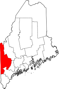 | |
| Plantations | ||
| Unorganized territories | ||
| CDPs | ||
| Other villages | ||
Coordinates: 44°09′38″N 70°59′06″W / 44.16056°N 70.98500°W