Cuba, Kansas
| Cuba, Kansas | |
|---|---|
| City | |
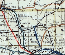
 Location within Republic County and Kansas | |
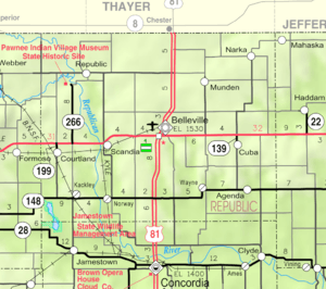 KDOT map of Republic County (legend) | |
| Coordinates: 39°48′8″N 97°27′26″W / 39.80222°N 97.45722°WCoordinates: 39°48′8″N 97°27′26″W / 39.80222°N 97.45722°W | |
| Country | United States |
| State | Kansas |
| County | Republic |
| Government | |
| • Type | Mayor–Council |
| Area[1] | |
| • Total | 0.31 sq mi (0.80 km2) |
| • Land | 0.31 sq mi (0.80 km2) |
| • Water | 0 sq mi (0 km2) |
| Elevation | 1,581 ft (482 m) |
| Population (2010)[2] | |
| • Total | 156 |
| • Estimate (2012[3]) | 152 |
| • Density | 500/sq mi (200/km2) |
| Time zone | Central (CST) (UTC-6) |
| • Summer (DST) | CDT (UTC-5) |
| ZIP code | 66940 |
| Area code(s) | 785 |
| FIPS code | 20-16625 [4] |
| GNIS feature ID | 0472855 [5] |
Cuba is a city in Republic County, Kansas, United States. As of the 2010 census, the city population was 156.[6]
History
The city of Cuba, Kansas was founded in 1868 by American southerners traveling westward after the American Civil War. The city received its name from one settler who had once lived on the island of Cuba.[7] Other early settlers of Cuba are Czech immigrants from Bohemia that settled in Cuba in the mid-1870s. Originally the majority of the population of Cuba were of Czech and Austrian descent.[7]
The entire town of Cuba moved to its present location in 1884 in order to be on the railroad that had been built through that territory.[8]
The town has received attention due to its small town America nature documented by photographer Jim Richardson. Cuba, Kansas and Jim Richardson were highlighted on the "CBS News Sunday Morning" show in 1983 and May 9, 2004 as well as the May 2004 issue of National Geographic magazine.[7]
Geography
Cuba is located at 39°48′8″N 97°27′26″W / 39.80222°N 97.45722°W (39.802222, -97.457128).[9] According to the United States Census Bureau, the city has a total area of 0.31 square miles (0.80 km2), all of it land.[1]
Demographics
| Historical population | |||
|---|---|---|---|
| Census | Pop. | %± | |
| 1890 | 415 | — | |
| 1900 | 445 | 7.2% | |
| 1910 | 466 | 4.7% | |
| 1920 | 432 | −7.3% | |
| 1930 | 403 | −6.7% | |
| 1940 | 363 | −9.9% | |
| 1950 | 345 | −5.0% | |
| 1960 | 336 | −2.6% | |
| 1970 | 290 | −13.7% | |
| 1980 | 286 | −1.4% | |
| 1990 | 242 | −15.4% | |
| 2000 | 231 | −4.5% | |
| 2010 | 156 | −32.5% | |
| Est. 2015 | 147 | [10] | −5.8% |
| U.S. Decennial Census | |||
2010 census
As of the census[2] of 2010, there were 156 people, 79 households, and 48 families residing in the city. The population density was 503.2 inhabitants per square mile (194.3/km2). There were 131 housing units at an average density of 422.6 per square mile (163.2/km2). The racial makeup of the city was 96.8% White, 1.3% Native American, and 1.9% from two or more races.
There were 79 households of which 12.7% had children under the age of 18 living with them, 55.7% were married couples living together, 3.8% had a female householder with no husband present, 1.3% had a male householder with no wife present, and 39.2% were non-families. 35.4% of all households were made up of individuals and 16.5% had someone living alone who was 65 years of age or older. The average household size was 1.97 and the average family size was 2.52.
The median age in the city was 55.8 years. 12.8% of residents were under the age of 18; 5.7% were between the ages of 18 and 24; 11.5% were from 25 to 44; 39.7% were from 45 to 64; and 30.1% were 65 years of age or older. The gender makeup of the city was 51.3% male and 48.7% female.
2000 census
As of the census[4] of 2000, there were 231 people, 110 households, and 72 families residing in the city. The population density was 761.0 people per square mile (297.3/km²). There were 148 housing units at an average density of 487.6 per square mile (190.5/km²). The racial makeup of the city was 98.27% White, 0.43% Native American, and 1.30% from two or more races. Hispanic or Latino of any race were 3.03% of the population.
There were 110 households out of which 23.6% had children under the age of 18 living with them, 58.2% were married couples living together, 5.5% had a female householder with no husband present, and 34.5% were non-families. 33.6% of all households were made up of individuals and 21.8% had someone living alone who was 65 years of age or older. The average household size was 2.10 and the average family size was 2.67.
In the city the population was spread out with 19.0% under the age of 18, 5.6% from 18 to 24, 21.6% from 25 to 44, 24.2% from 45 to 64, and 29.4% who were 65 years of age or older. The median age was 47 years. For every 100 females there were 94.1 males. For every 100 females age 18 and over, there were 94.8 males.
The median income for a household in the city was $28,333, and the median income for a family was $37,292. Males had a median income of $24,375 versus $17,857 for females. The per capita income for the city was $17,103. About 3.1% of families and 6.8% of the population were below the poverty line, including 8.5% of those under the age of eighteen and 9.1% of those sixty five or over.
Government
The Cuba government consists of a mayor and five council members. The council meets the 1st Monday of each month at 7PM.[11]
References
- 1 2 "US Gazetteer files 2010". United States Census Bureau. Archived from the original on 2012-01-24. Retrieved 2012-07-06.
- 1 2 "American FactFinder". United States Census Bureau. Retrieved 2012-07-06.
- ↑ "Population Estimates". United States Census Bureau. Archived from the original on 2013-06-17. Retrieved 2013-05-29.
- 1 2 "American FactFinder". United States Census Bureau. Archived from the original on 2013-09-11. Retrieved 2008-01-31.
- ↑ "US Board on Geographic Names". United States Geological Survey. 2007-10-25. Retrieved 2008-01-31.
- ↑ "2010 City Population and Housing Occupancy Status". U.S. Census Bureau. Archived from the original on July 21, 2011. Retrieved May 10, 2011.
- 1 2 3 Pulling Together: 30 Years in the Life of Cuba, Kansas, Jim Richardson, National Geographic
- ↑ Blackmar, Frank Wilson (1912). Kansas: A Cyclopedia of State History, Embracing Events, Institutions, Industries, Counties, Cities, Towns, Prominent Persons, Etc. Standard Publishing Company. p. 486.
- ↑ "US Gazetteer files: 2010, 2000, and 1990". United States Census Bureau. 2011-02-12. Retrieved 2011-04-23.
- ↑ "Annual Estimates of the Resident Population for Incorporated Places: April 1, 2010 to July 1, 2015". Retrieved July 2, 2016.
- ↑ Cuba - Directory of Public Officials
External links
| Wikimedia Commons has media related to Cuba, Kansas. |
- City
- Schools
- USD 109, local school district
- Photos
- Maps
- Cuba City Map, KDOT
Municipalities and communities of Republic County, Kansas, United States | ||
|---|---|---|
| Cities | 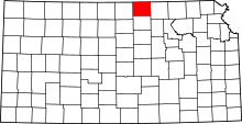 | |
| Townships | ||
| Unincorporated communities | ||