Republic County, Kansas
| Republic County, Kansas | |
|---|---|
| County | |
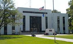 Republic County Courthouse in Belleville | |
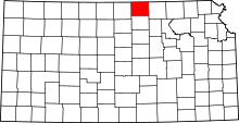 Location in the U.S. state of Kansas | |
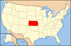 Kansas's location in the U.S. | |
| Founded | February 27, 1860 |
| Named for | Republican River |
| Seat | Belleville |
| Largest city | Belleville |
| Area | |
| • Total | 720.31 sq mi (1,866 km2) |
| • Land | 716.38 sq mi (1,855 km2) |
| • Water | 3.93 sq mi (10 km2), 0.55% |
| Population | |
| • (2010) | 4,980 |
| • Density | 7.2/sq mi (3/km²) |
| Congressional district | 1st |
| Time zone | Central: UTC-6/-5 |
| Website |
RepublicCounty |
Coordinates: 39°48′N 97°38′W / 39.800°N 97.633°W
Republic County (standard abbreviation: RP) is a county located in the state of Kansas. As of the 2010 census, the county population was 4,980.[1] The largest city and county seat is Belleville.[2] It is south from the Nebraska state line.
History
Early history
For many millennia, the Great Plains of North America was inhabited by nomadic Native Americans. From the 16th century to 18th century, the Kingdom of France claimed ownership of large parts of North America. In 1762, after the French and Indian War, France secretly ceded New France to Spain, per the Treaty of Fontainebleau.
19th century
In 1802, Spain returned most of the land to France, but keeping title to about 7,500 square miles. In 1803, most of the land for modern day Kansas was acquired by the United States from France as part of the 828,000 square mile Louisiana Purchase for 2.83 cents per acre.
In 1854, the Kansas Territory was organized, then in 1861 Kansas became the 34th U.S. state. In 1860, Republic County was established. Republic County was first settled around 1860 by Daniel and Conrad Myers.[3] The territory was principally inhabited by Pawnees, Iowas, and Otoes who peaceable greeted the incoming settlers, who were mostly farmers. By 1868, Republic County was holding elections.
In 1887, Atchison, Topeka and Santa Fe Railway built a branch line from Neva (3 miles west of Strong City) to Superior, Nebraska. This branch line connected Strong City, Neva, Rockland, Diamond Springs, Burdick, Lost Springs, Jacobs, Hope, Navarre, Enterprise, Abilene, Talmage, Manchester, Longford, Oak Hill, Miltonvale, Aurora, Huscher, Concordia, Kackley, Courtland, Webber, Superior. At some point, the line from Neva to Lost Springs was pulled but the right of way has not been abandoned. This branch line was originally called "Strong City and Superior line" but later the name was shortened to the "Strong City line". In 1996, the Atchison, Topeka and Santa Fe Railway merged with Burlington Northern Railroad and renamed to the current BNSF Railway. Most locals still refer to this railroad as the "Santa Fe".
During the late 19th century, Belleville became the urban center for the immigrants that were attracted to the surrounding areas, most notably from Sweden and Bohemia (now Czech Republic).
Geography
According to the 2000 census, the county has a total area of 720.31 square miles (1,865.6 km2), of which 716.38 square miles (1,855.4 km2) (or 99.45%) is land and 3.93 square miles (10.2 km2) (or 0.55%) is water.[4][5]
Adjacent counties
- Thayer County, Nebraska (north)
- Jefferson County, Nebraska (northeast)
- Washington County (east)
- Cloud County (south)
- Jewell County (west)
- Nuckolls County, Nebraska (northwest)
Demographics
| Historical population | |||
|---|---|---|---|
| Census | Pop. | %± | |
| 1870 | 1,281 | — | |
| 1880 | 14,913 | 1,064.2% | |
| 1890 | 19,002 | 27.4% | |
| 1900 | 18,248 | −4.0% | |
| 1910 | 17,447 | −4.4% | |
| 1920 | 15,855 | −9.1% | |
| 1930 | 14,745 | −7.0% | |
| 1940 | 13,124 | −11.0% | |
| 1950 | 11,478 | −12.5% | |
| 1960 | 9,768 | −14.9% | |
| 1970 | 8,498 | −13.0% | |
| 1980 | 7,569 | −10.9% | |
| 1990 | 6,482 | −14.4% | |
| 2000 | 5,835 | −10.0% | |
| 2010 | 4,980 | −14.7% | |
| Est. 2015 | 4,725 | [6] | −5.1% |
| U.S. Decennial Census[7] 1790-1960[8] 1900-1990[9] 1990-2000[10] 2010-2013[1] | |||
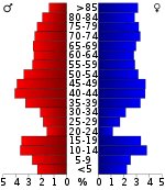
As of the census[11] of 2000, there were 5,835 people, 2,557 households, and 1,685 families residing in the county. The population density was 8 people per square mile (3/km²). There were 3,113 housing units at an average density of 4 per square mile (2/km²). The racial makeup of the county was 98.56% White, 0.26% Black or African American, 0.21% Native American, 0.19% Asian, 0.33% from other races, and 0.46% from two or more races. 0.94% of the population were Hispanic or Latino of any race. 24.1% were of German, 13.6% Swedish, 12.4% Czech, 9.2% English, 9.0% Irish and 8.6% American ancestry according to Census 2000.
There were 2,557 households out of which 25.60% had children under the age of 18 living with them, 58.80% were married couples living together, 4.80% had a female householder with no husband present, and 34.10% were non-families. 31.80% of all households were made up of individuals and 18.00% had someone living alone who was 65 years of age or older. The average household size was 2.23 and the average family size was 2.80.
In the county the population was spread out with 22.30% under the age of 18, 4.50% from 18 to 24, 22.10% from 25 to 44, 25.00% from 45 to 64, and 26.10% who were 65 years of age or older. The median age was 46 years. For every 100 females there were 93.20 males. For every 100 females age 18 and over, there were 90.80 males.
The median income for a household in the county was $30,494, and the median income for a family was $39,215. Males had a median income of $25,260 versus $17,274 for females. The per capita income for the county was $17,433. About 6.00% of families and 9.10% of the population were below the poverty line, including 12.40% of those under age 18 and 8.90% of those age 65 or over.
Law and government
Republic County was a prohibition, or "dry", county until the Kansas Constitution was amended in 1986 and voters approved the sale of alcoholic liquor by the individual drink with a 30% food sales requirement.[12]
Education
Unified school districts
Communities
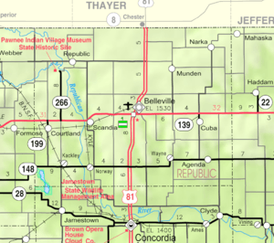
Incorporated cities
Unincorporated cities
Ghost town
Townships
Republic County is divided into twenty townships. The city of Belleville is considered governmentally independent and is excluded from the census figures for the townships. In the following table, the population center is the largest city (or cities) included in that township's population total, if it is of a significant size.
| Township | FIPS | Population center |
Population | Population density /km² (/sq mi) |
Land area km² (sq mi) | Water area km² (sq mi) | Water % | Geographic coordinates |
|---|---|---|---|---|---|---|---|---|
| Albion | 00900 | 174 | 2 (5) | 92 (36) | 0 (0) | 0.12% | 39°57′35″N 97°25′29″W / 39.95972°N 97.42472°W | |
| Beaver | 05150 | 137 | 2 (4) | 91 (35) | 3 (1) | 3.04% | 39°42′17″N 97°51′59″W / 39.70472°N 97.86639°W | |
| Belleville | 05625 | 231 | 3 (7) | 89 (34) | 0 (0) | 0.11% | 39°47′14″N 97°38′35″W / 39.78722°N 97.64306°W | |
| Big Bend | 06550 | 242 | 3 (7) | 92 (35) | 1 (0) | 1.39% | 39°57′0″N 97°50′53″W / 39.95000°N 97.84806°W | |
| Courtland | 16050 | 450 | 5 (12) | 94 (36) | 0 (0) | 0.06% | 39°46′56″N 97°52′51″W / 39.78222°N 97.88083°W | |
| Elk Creek | 20275 | 175 | 2 (5) | 94 (36) | 0 (0) | 0.15% | 39°42′16″N 97°25′41″W / 39.70444°N 97.42806°W | |
| Fairview | 22575 | 155 | 2 (4) | 94 (36) | 0 (0) | 0.49% | 39°52′50″N 97°31′54″W / 39.88056°N 97.53167°W | |
| Farmington | 23200 | 81 | 1 (2) | 93 (36) | 0 (0) | 0.20% | 39°52′20″N 97°25′24″W / 39.87222°N 97.42333°W | |
| Freedom | 24675 | 186 | 2 (5) | 90 (35) | 0 (0) | 0.28% | 39°51′31″N 97°38′26″W / 39.85861°N 97.64056°W | |
| Grant | 28050 | 77 | 1 (2) | 95 (37) | 0 (0) | 0.15% | 39°42′5″N 97°32′31″W / 39.70139°N 97.54194°W | |
| Jefferson | 35325 | 107 | 1 (3) | 95 (37) | 0 (0) | 0.05% | 39°47′29″N 97°32′33″W / 39.79139°N 97.54250°W | |
| Liberty | 40325 | 52 | 1 (1) | 93 (36) | 0 (0) | 0.19% | 39°57′2″N 97°38′30″W / 39.95056°N 97.64167°W | |
| Lincoln | 41075 | 103 | 1 (3) | 92 (36) | 0 (0) | 0.09% | 39°41′58″N 97°38′57″W / 39.69944°N 97.64917°W | |
| Norway | 51575 | 163 | 2 (5) | 92 (36) | 1 (0) | 1.19% | 39°42′17″N 97°46′9″W / 39.70472°N 97.76917°W | |
| Richland | 59575 | 318 | 3 (9) | 92 (36) | 0 (0) | 0.11% | 39°47′30″N 97°26′4″W / 39.79167°N 97.43444°W | |
| Rose Creek | 61200 | 170 | 2 (5) | 94 (36) | 0 (0) | 0.44% | 39°57′27″N 97°32′13″W / 39.95750°N 97.53694°W | |
| Scandia | 63375 | 541 | 6 (15) | 92 (36) | 1 (0) | 1.23% | 39°47′28″N 97°46′27″W / 39.79111°N 97.77417°W | |
| Union | 72300 | 51 | 1 (1) | 93 (36) | 0 (0) | 0.18% | 39°52′0″N 97°46′5″W / 39.86667°N 97.76806°W | |
| Washington | 75700 | 95 | 1 (3) | 93 (36) | 0 (0) | 0.24% | 39°57′57″N 97°45′14″W / 39.96583°N 97.75389°W | |
| White Rock | 77975 | 88 | 1 (2) | 92 (36) | 1 (0) | 1.09% | 39°52′34″N 97°51′54″W / 39.87611°N 97.86500°W |
Notable people
Arts and entertainment
- Robert Gordon, actor (1895–1971)
- Greta Granstedt, actress[13]
- Harry A. Pollard, silent film actor[14]
- Steve Tamerius, Emmy-winning TV writer with "Jeopardy!"[15]
Athletes
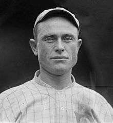
- Herb Bradley, Major League Baseball player[16]
- Thomas Bushby, player for the Cincinnati "Football" Reds in 1934 and the Philadelphia Eagles in 1935.[17]
- Lloyd Cardwell, American football player
- Larry Cheney, Major League Baseball player[18]
- Dean Nesmith, professional football player, Olympic athletic trainer[19]
- Ronald Severa, Olympic water polo player, 1956 and 1960.
- Anthony Zuzzio, offensive lineman for the Detroit Lions.[20]
Clergy
- Allen Wikgren, pastor and Bible scholar[21]
- Richard B. Wilke, former pastor in Scandia, writer of the Disciple ministry series
Journalists
- J. C. Humphrey, founder of the Belleville Telescope newspaper[22]
Medicine
- C. M. Arbuthnot, early physician and pharmacist in the county[23]
Philanthropy
- Elizabeth A. Johnson, Kansas history advocate[24]
Politicians
- Clay Aurand, member of Kansas Legislature[25]
- Charles H. Blosser (1895—1989), namesake of Blosser Municipal Airport in Concordia, Kansas
- Edwin C. Johnson, Governor of Colorado[26]
- William C. Perry, 34th Chief Justice of the Oregon Supreme Court[27]
- Isaac O. Savage, state senator in the Kansas legislature[28]
Settlers
- Ransom Henry Gile, early settler in Scandia[29]
- Thomas Lovewell, founded settlement of White Rock,[30] namesake of Lovewell Reservoir[31]
See also
|
|
References
- 1 2 "State & County QuickFacts". United States Census Bureau. Retrieved July 28, 2014.
- ↑ "Find a County". National Association of Counties. Retrieved 2011-06-07.
- ↑ Savage., I. O. (1901). Carolyn Ward, transcribed July 2006, ed. A history of Republic County, Kansas : embracing a full and complete account of all the leading events in its history, from its first settlement down to June 1, '01. Jones & Chubbic, Beloit, KS. p. 35.
- ↑ "Census 2000 U.S. Gazetteer Files: Counties". United States Census. Retrieved 2011-02-13.
- ↑ "US Gazetteer files: 2010, 2000, and 1990". United States Census Bureau. 2011-02-12. Retrieved 2011-04-23.
- ↑ "County Totals Dataset: Population, Population Change and Estimated Components of Population Change: April 1, 2010 to July 1, 2015". Retrieved July 2, 2016.
- ↑ "U.S. Decennial Census". United States Census Bureau. Retrieved July 28, 2014.
- ↑ "Historical Census Browser". University of Virginia Library. Retrieved July 28, 2014.
- ↑ "Population of Counties by Decennial Census: 1900 to 1990". United States Census Bureau. Retrieved July 28, 2014.
- ↑ "Census 2000 PHC-T-4. Ranking Tables for Counties: 1990 and 2000" (PDF). United States Census Bureau. Retrieved July 28, 2014.
- ↑ "American FactFinder". United States Census Bureau. Retrieved 2008-01-31.
- ↑ "Map of Wet and Dry Counties". Alcoholic Beverage Control, Kansas Department of Revenue. November 2006. Retrieved 2007-12-28.
- ↑ Greta Granstedt Biography at the Internet Movie Database
- ↑ Harry A. Pollard at the Internet Movie Database
- ↑ "Jeopardy! Official Site | Jeopardy.com". www.jeopardy.com. Retrieved 2016-07-10.
- ↑ "Herb Bradley". Retrosheet.com. Retrieved March 25, 2012.
- ↑ "Tom Bushby". Pro Football Reference.com. Retrieved March 28, 2012.
- ↑ "Larry Cheney Stats". Baseball Almanac.com. Retrieved March 25, 2012.
- ↑ "KATS Hall of Fame". Kansas Athletic Trainers Society. Retrieved September 14, 2012.
- ↑ "Tony Zuzzio". DatabaseFootball.com. Retrieved March 28, 2012.
- ↑ "In memoriam: Allen Wikgren". The University of Chicago Chronicle. June 11, 1998. Retrieved March 27, 2012.
- ↑ Cutler, William (1883). "4". History of the State of Kansas. Chicago, Illinois: A. T. Andreas. Retrieved April 2, 2012.
- ↑ Cutler, William (1883). "3". History of the State of Kansas. Chicago, Illinois: A. T. Andreas.
- ↑ Savage, I. O. (1901). Carolyn Ward (Transcribed July 2006), ed. A history of Republic County, Kansas : embracing a full and complete account of all the leading events in its history, from its first settlement down to June 1, '01. Beloit, Kansas: Published by Jones & Chubbic. p. 11; 20. Retrieved March 25, 2012.
- ↑ Project Vote Smart - Rep. Aurand Biography
- ↑ "JOHNSON, Edwin Carl, (1884 - 1970)". United States Congress. Retrieved March 25, 2012.
- ↑ Former justice dies at age 85. Statesman Journal, November 1, 1985.
- ↑ "Kansas Legislators Past and Present > Saar to Scott". Kansas State Library. Retrieved March 25, 2012.
- ↑ Cutler, William (1883). "REPUBLIC COUNTY, Part 6: Scandia". History of the State of Kansas. Chicago, Illinois: A. T. Andreas. Retrieved April 3, 2012.
- ↑ Blackmar, Frank (1912). Kansas: a cyclopedia of state history, embracing events, institutions, industries, counties, cities, towns, prominent persons, etc. Chicago, Illinois: Standard Publishing Company. p. 907.
- ↑ "Lovewell Family Meets at Lovewell Lake". The Superior Express. June 7, 2007. Retrieved March 27, 2012.
Further reading
- History of the State of Kansas; William G. Cutler; A.T. Andreas Publisher; 1883. (Online HTML eBook)
- Kansas : A Cyclopedia of State History, Embracing Events, Institutions, Industries, Counties, Cities, Towns, Prominent Persons, Etc; 3 Volumes; Frank W. Blackmar; Standard Publishing Co; 944 / 955 / 824 pages; 1912. (Volume1 - Download 54MB PDF eBook),(Volume2 - Download 53MB PDF eBook), (Volume3 - Download 33MB PDF eBook)
External links
| Wikimedia Commons has media related to Republic County, Kansas. |
- County
- Other
- Maps
- Republic County Maps: Current, Historic, KDOT
- Kansas Highway Maps: Current, Historic, KDOT
- Kansas Railroad Maps: Current, 1996, 1915, KDOT and Kansas Historical Society
 |
Nuckolls County, Nebraska | Thayer County, Nebraska | Jefferson County, Nebraska | |
| Jewell County | |
Washington County | ||
| ||||
| | ||||
| Cloud County |
Municipalities and communities of Republic County, Kansas, United States | ||
|---|---|---|
| Cities | | |
| Townships | ||
| Unincorporated communities | ||