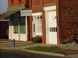
Cumberland, Iowa
| Cumberland | |
|---|---|
| City | |
 | |
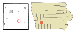 Location in the State of Iowa | |
| Coordinates: 41°16′25″N 94°52′16″W / 41.27361°N 94.87111°WCoordinates: 41°16′25″N 94°52′16″W / 41.27361°N 94.87111°W | |
| Country |
|
| State |
|
| County | Cass |
| Area[1] | |
| • Total | 0.60 sq mi (1.55 km2) |
| • Land | 0.60 sq mi (1.55 km2) |
| • Water | 0 sq mi (0 km2) |
| Elevation | 1,302 ft (397 m) |
| Population (2010)[2] | |
| • Total | 262 |
| • Estimate (2012[3]) | 259 |
| • Density | 436.7/sq mi (168.6/km2) |
| Time zone | CST (UTC-6) |
| • Summer (DST) | CDT (UTC-5) |
| ZIP code | 50843 |
| Area code(s) | 712 |
| FIPS code | 19-17760 |
| GNIS feature ID | 0455754 |
| Website | http://www.cumberlandiowa.com/ |
Cumberland is a city in Cass County, Iowa, United States. The population was 262 at the 2010 census. Cumberland's sister community is Massena, Iowa.
Geography
Cumberland is located at 41°16′25″N 94°52′16″W / 41.27361°N 94.87111°W (41.273650, -94.871180).[4]
According to the United States Census Bureau, the city has a total area of 0.60 square miles (1.55 km2), all of it land.[1]
Demographics
| Historical Populations | ||
|---|---|---|
| Year | Pop. | ±% |
| 1900 | 591 | — |
| 1910 | 552 | −6.6% |
| 1920 | 561 | +1.6% |
| 1930 | 595 | +6.1% |
| 1940 | 578 | −2.9% |
| 1950 | 493 | −14.7% |
| 1960 | 425 | −13.8% |
| 1970 | 385 | −9.4% |
| 1980 | 351 | −8.8% |
| 1990 | 295 | −16.0% |
| 2000 | 281 | −4.7% |
| 2010 | 262 | −6.8% |
| 2014 | 253 | −3.4% |
| 2015 | 253 | +0.0% |
| Source:"American FactFinder". United States Census Bureau. and Iowa Data Center Source: | ||
2010 census
As of the census[2] of 2010, there were 262 people, 116 households, and 66 families residing in the city. The population density was 436.7 inhabitants per square mile (168.6/km2). There were 132 housing units at an average density of 220.0 per square mile (84.9/km2). The racial makeup of the city was 98.9% White, 0.4% Native American, 0.4% Pacific Islander, and 0.4% from two or more races. Hispanic or Latino of any race were 0.4% of the population.
There were 116 households of which 27.6% had children under the age of 18 living with them, 44.0% were married couples living together, 6.9% had a female householder with no husband present, 6.0% had a male householder with no wife present, and 43.1% were non-families. 37.9% of all households were made up of individuals and 16.3% had someone living alone who was 65 years of age or older. The average household size was 2.26 and the average family size was 2.94.
The median age in the city was 41.6 years. 25.2% of residents were under the age of 18; 6.8% were between the ages of 18 and 24; 21.4% were from 25 to 44; 28.6% were from 45 to 64; and 17.9% were 65 years of age or older. The gender makeup of the city was 50.4% male and 49.6% female.
2000 census
As of the census[6] of 2000, there were 281 people, 128 households, and 82 families residing in the city. The population density was 466.9 people per square mile (180.8/km²). There were 144 housing units at an average density of 239.3 per square mile (92.7/km²). The racial makeup of the city was 99.29% White, 0.36% Native American, and 0.36% from two or more races.
There were 128 households out of which 25.0% had children under the age of 18 living with them, 59.4% were married couples living together, 3.9% had a female householder with no husband present, and 35.2% were non-families. 34.4% of all households were made up of individuals and 17.2% had someone living alone who was 65 years of age or older. The average household size was 2.20 and the average family size was 2.81.
In the city the population was spread out with 21.0% under the age of 18, 4.6% from 18 to 24, 25.6% from 25 to 44, 24.9% from 45 to 64, and 23.8% who were 65 years of age or older. The median age was 44 years. For every 100 females there were 100.7 males. For every 100 females age 18 and over, there were 100.0 males.
The median income for a household in the city was $28,750, and the median income for a family was $39,167. Males had a median income of $26,786 versus $15,500 for females. The per capita income for the city was $15,662. About 6.1% of families and 8.3% of the population were below the poverty line, including 10.4% of those under the age of eighteen and 6.3% of those sixty five or over.
References
- 1 2 "US Gazetteer files 2010". United States Census Bureau. Archived from the original on 2012-01-24. Retrieved 2012-05-11.
- 1 2 "American FactFinder". United States Census Bureau. Retrieved 2012-05-11.
- ↑ "Population Estimates". United States Census Bureau. Archived from the original on 2013-06-17. Retrieved 2013-05-23.
- ↑ "US Gazetteer files: 2010, 2000, and 1990". United States Census Bureau. 2011-02-12. Retrieved 2011-04-23.
- ↑ "Census of Population and Housing". Census.gov. Archived from the original on May 11, 2015. Retrieved June 4, 2015.
- ↑ "American FactFinder". United States Census Bureau. Archived from the original on 2013-09-11. Retrieved 2008-01-31.
External links
Municipalities and communities of Cass County, Iowa, United States | ||
|---|---|---|
| Cities | ||
| Townships | ||