Dakota City, Iowa
| Dakota City, Iowa | |
|---|---|
| City | |
 | |
 Location of Dakota City, Iowa | |
| Coordinates: 42°43′19″N 94°12′1″W / 42.72194°N 94.20028°WCoordinates: 42°43′19″N 94°12′1″W / 42.72194°N 94.20028°W | |
| Country |
|
| State |
|
| County | Humboldt |
| Area[1] | |
| • Total | 0.78 sq mi (2.02 km2) |
| • Land | 0.74 sq mi (1.92 km2) |
| • Water | 0.04 sq mi (0.10 km2) |
| Elevation | 1,125 ft (343 m) |
| Population (2010)[2] | |
| • Total | 843 |
| • Estimate (2012[3]) | 835 |
| • Density | 1,139.2/sq mi (439.8/km2) |
| Time zone | Central (CST) (UTC-6) |
| • Summer (DST) | CDT (UTC-5) |
| ZIP code | 50529 |
| Area code(s) | 515 |
| FIPS code | 19-18075 |
| GNIS feature ID | 1690853 |
Dakota City is a city in and the county seat of Humboldt County, Iowa, United States.[4] The population was 843 at the 2010 census. Dakota City shares its western border with the much larger city of Humboldt. It is the least populous County Seat in Iowa.
History
Dakota City was laid out in 1855.[5] It was named after the Dakota people.[6] A post office was established as Dakotah in 1856, and renamed Dakota City in 1924.[7]
Geography
Dakota City's longitude and latitude coordinates in decimal form are 42.721944, -94.200317.[8]
According to the United States Census Bureau, the city has a total area of 0.78 square miles (2.02 km2), of which, 0.74 square miles (1.92 km2) is land and 0.04 square miles (0.10 km2) is water.[1]
Demographics
| Historical populations | ||
|---|---|---|
| Year | Pop. | ±% |
| 1870 | 162 | — |
| 1880 | 248 | +53.1% |
| 1890 | 353 | +42.3% |
| 1900 | 362 | +2.5% |
| 1910 | 391 | +8.0% |
| 1920 | 439 | +12.3% |
| 1930 | 448 | +2.1% |
| 1940 | 537 | +19.9% |
| 1950 | 637 | +18.6% |
| 1960 | 706 | +10.8% |
| 1970 | 746 | +5.7% |
| 1980 | 1,072 | +43.7% |
| 1990 | 1,024 | −4.5% |
| 2000 | 911 | −11.0% |
| 2010 | 843 | −7.5% |
| 2014 | 822 | −2.5% |
| 2015 | 813 | −1.1% |
| Sources:[9][10] Source: | ||
2010 census
As of the census[2] of 2010, there were 843 people, 351 households, and 238 families residing in the city. The population density was 1,139.2 inhabitants per square mile (439.8/km2). There were 382 housing units at an average density of 516.2 per square mile (199.3/km2). The racial makeup of the city was 96.0% White, 0.1% African American, 0.5% Native American, 0.4% Asian, 1.4% from other races, and 1.7% from two or more races. Hispanic or Latino of any race were 4.2% of the population.
There were 351 households of which 32.2% had children under the age of 18 living with them, 56.4% were married couples living together, 6.6% had a female householder with no husband present, 4.8% had a male householder with no wife present, and 32.2% were non-families. 25.6% of all households were made up of individuals and 11.7% had someone living alone who was 65 years of age or older. The average household size was 2.40 and the average family size was 2.89.
The median age in the city was 39.3 years. 23.7% of residents were under the age of 18; 8% were between the ages of 18 and 24; 26.3% were from 25 to 44; 27.7% were from 45 to 64; and 14.4% were 65 years of age or older. The gender makeup of the city was 51.0% male and 49.0% female.
2000 census
As of the census[12] of 2000, there were 911 people, 356 households, and 253 families residing in the city. The population density was 1,238.0 people per square mile (475.3/km²). There were 379 housing units at an average density of 515.0 per square mile (197.7/km²). The racial makeup of the city was 99.01% White, 0.11% Native American, 0.11% Asian, 0.44% from other races, and 0.33% from two or more races. Hispanic or Latino of any race were 1.43% of the population.
There were 356 households out of which 38.5% had children under the age of 18 living with them, 57.3% were married couples living together, 9.6% had a female householder with no husband present, and 28.9% were non-families. 25.0% of all households were made up of individuals and 11.5% had someone living alone who was 65 years of age or older. The average household size was 2.56 and the average family size was 3.04.
In the city the population was spread out with 28.0% under the age of 18, 9.9% from 18 to 24, 31.0% from 25 to 44, 19.9% from 45 to 64, and 11.3% who were 65 years of age or older. The median age was 34 years. For every 100 females there were 101.5 males. For every 100 females age 18 and over, there were 94.1 males.
The median household income was $33,977 and the median family income was $39,306. Males had a median income of $30,250 versus $23,229 for females. The per capita income for the city was $15,441. About 5.2% of families and 6.6% of the population were below the poverty line, including 6.3% of those under age 18 and 7.3% of those age 65 or over.
Point of interest
The Three Rivers Bike Trail, built on an abandoned railroad grade, passes through town. One of its interesting features is a trestle just south of its highway 3 overpass where it crosses another abandoned railway — also converted to a trail. The "Three Rivers" refers to the East and West Forks of the Des Moines River and to the Boone River, all of which it spans.
Notable people
- Harry Reasoner - CBS correspondent
See also
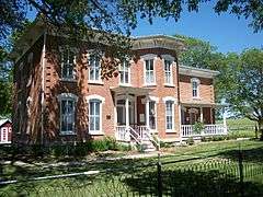
- Corydon Brown House is listed on the National Register of Historic Places
- Humboldt County Courthouse
References
- 1 2 "US Gazetteer files 2010". United States Census Bureau. Archived from the original on January 24, 2012. Retrieved 2012-05-11.
- 1 2 "American FactFinder". United States Census Bureau. Retrieved 2012-05-11.
- ↑ "Population Estimates". United States Census Bureau. Archived from the original on June 17, 2013. Retrieved 2013-05-23.
- ↑ "Find a County". National Association of Counties. Archived from the original on May 31, 2011. Retrieved 2011-06-07.
- ↑ History of Kossuth and Humboldt Counties, Iowa. Union Publishing Company. 1884. p. 741. Note that Google Books misspells "Humboldt".
- ↑ Company, Chicago and North Western Railway (1908). A History of the Origin of the Place Names Connected with the Chicago & North Western and Chicago, St. Paul, Minneapolis & Omaha Railways. p. 62.
- ↑ "Humboldt County". Jim Forte Postal History. Retrieved 1 March 2015.
- ↑ "US Gazetteer files: 2010, 2000, and 1990". United States Census Bureau. 2011-02-12. Retrieved 2011-04-23.
- ↑ "American FactFinder". United States Census Bureau.
- ↑ Iowa Data Center
- ↑ "Census of Population and Housing". Census.gov. Archived from the original on May 11, 2015. Retrieved June 4, 2015.
- ↑ "American FactFinder". United States Census Bureau. Archived from the original on September 11, 2013. Retrieved 2008-01-31.
External links
| Wikimedia Commons has media related to Dakota City, Iowa. |
- Three Rivers Trail
- City-Data Comprehensive Statistical Data and more about Dakota City
Municipalities and communities of Humboldt County, Iowa, United States | ||
|---|---|---|
| Cities | ||
| Townships | ||
| Ghost town |
| |
| Footnotes | ‡This populated place also has portions in an adjacent county or counties | |