Danville, Kansas
| Danville, Kansas | |
|---|---|
| City | |
 Location within Harper County and Kansas | |
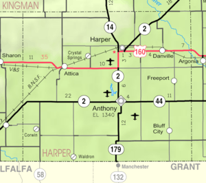 KDOT map of Harper County (legend) | |
| Coordinates: 37°17′12″N 97°53′34″W / 37.28667°N 97.89278°WCoordinates: 37°17′12″N 97°53′34″W / 37.28667°N 97.89278°W | |
| Country | United States |
| State | Kansas |
| County | Harper |
| Area[1] | |
| • Total | 0.08 sq mi (0.21 km2) |
| • Land | 0.08 sq mi (0.21 km2) |
| • Water | 0 sq mi (0 km2) |
| Elevation | 1,342 ft (409 m) |
| Population (2010)[2] | |
| • Total | 38 |
| • Estimate (2015)[3] | 36 |
| • Density | 480/sq mi (180/km2) |
| Time zone | Central (CST) (UTC-6) |
| • Summer (DST) | CDT (UTC-5) |
| ZIP code | 67036 |
| Area code | 620 |
| FIPS code | 20-17000 [4] |
| GNIS feature ID | 0470194 [5] |
Danville is a city in Harper County, Kansas, United States. As of the 2010 census, the city population was 38.[6]
History
Danville was originally known as Coleville, and under the latter name was laid out in 1880 by Mrs. J. E. Cole.[7] When Mrs. Cole later sold the town site, the name was changed to Danville, after Danville, Ohio.[7][8]
Geography
Danville is located at 37°17′12″N 97°53′34″W / 37.28667°N 97.89278°W (37.286771, -97.892715).[9] According to the United States Census Bureau, the city has a total area of 0.08 square miles (0.21 km2), all of it land.[1]
Demographics
| Historical population | |||
|---|---|---|---|
| Census | Pop. | %± | |
| 1930 | 130 | — | |
| 1940 | 134 | 3.1% | |
| 1950 | 122 | −9.0% | |
| 1960 | 118 | −3.3% | |
| 1970 | 80 | −32.2% | |
| 1980 | 71 | −11.2% | |
| 1990 | 56 | −21.1% | |
| 2000 | 59 | 5.4% | |
| 2010 | 38 | −35.6% | |
| Est. 2015 | 36 | [3] | −5.3% |
| U.S. Decennial Census | |||
2010 census
As of the census[2] of 2010, there were 38 people, 19 households, and 8 families residing in the city. The population density was 475.0 inhabitants per square mile (183.4/km2). There were 26 housing units at an average density of 325.0 per square mile (125.5/km2). The racial makeup of the city was 100.0% White.
There were 19 households of which 15.8% had children under the age of 18 living with them, 31.6% were married couples living together, 10.5% had a female householder with no husband present, and 57.9% were non-families. 42.1% of all households were made up of individuals and 10.5% had someone living alone who was 65 years of age or older. The average household size was 2.00 and the average family size was 2.88.
The median age in the city was 47.5 years. 21.1% of residents were under the age of 18; 2.5% were between the ages of 18 and 24; 23.8% were from 25 to 44; 36.9% were from 45 to 64; and 15.8% were 65 years of age or older. The gender makeup of the city was 47.4% male and 52.6% female.
2000 census
As of the census[4] of 2000, there were 59 people, 26 households, and 17 families residing in the city. The population density was 685.5 people per square mile (253.1/km²). There were 30 housing units at an average density of 348.6 per square mile (128.7/km²). The racial makeup of the city was 96.61% White and 3.39% Native American.
There were 26 households out of which 23.1% had children under the age of 18 living with them, 53.8% were married couples living together, 7.7% had a female householder with no husband present, and 30.8% were non-families. 23.1% of all households were made up of individuals and 3.8% had someone living alone who was 65 years of age or older. The average household size was 2.27 and the average family size was 2.67.
In the city the population was spread out with 20.3% under the age of 18, 20.3% from 18 to 24, 18.6% from 25 to 44, 22.0% from 45 to 64, and 18.6% who were 65 years of age or older. The median age was 36 years. For every 100 females there were 103.4 males. For every 100 females age 18 and over, there were 135.0 males.
The median income for a household in the city was $20,313, and the median income for a family was $19,583. Males had a median income of $35,625 versus $0 for females. The per capita income for the city was $10,743. There were 13.3% of families and 12.2% of the population living below the poverty line, including 11.8% of under eighteens and none of those over 64.
References
- 1 2 "US Gazetteer files 2010". United States Census Bureau. Retrieved 2012-07-06.
- 1 2 "American FactFinder". United States Census Bureau. Retrieved 2012-07-06.
- 1 2 "Annual Estimates of the Resident Population for Incorporated Places: April 1, 2010 to July 1, 2015". Retrieved July 2, 2016.
- 1 2 "American FactFinder". United States Census Bureau. Retrieved 2008-01-31.
- ↑ "US Board on Geographic Names". United States Geological Survey. 2007-10-25. Retrieved 2008-01-31.
- ↑ "2010 City Population and Housing Occupancy Status". U.S. Census Bureau. Retrieved March 6, 2011.
- 1 2 Blackmar, Frank Wilson (1912). Kansas: A Cyclopedia of State History, Embracing Events, Institutions, Industries, Counties, Cities, Towns, Prominent Persons, Etc. Standard Publishing Company. p. 494.
- ↑ "Profile for Danville, Kansas". ePodunk. Retrieved 11 June 2014.
- ↑ "US Gazetteer files: 2010, 2000, and 1990". United States Census Bureau. 2011-02-12. Retrieved 2011-04-23.
External list
| Wikimedia Commons has media related to Danville, Kansas. |
- City
- Schools
- USD 359, local school district
- Maps
- Danville City Map, KDOT
Municipalities and communities of Harper County, Kansas, United States | ||
|---|---|---|
| Cities |  | |
| Unincorporated communities | ||
| Townships | ||
| Ghost town | ||