DeForest, Wisconsin
| DeForest, Wisconsin | |
|---|---|
| Village | |
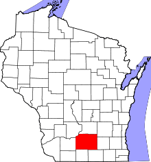
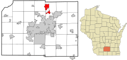 Location in Dane County and the state of Wisconsin. | |
| Coordinates: 43°14′45″N 89°20′45″W / 43.24583°N 89.34583°WCoordinates: 43°14′45″N 89°20′45″W / 43.24583°N 89.34583°W | |
| Country | United States |
| State | Wisconsin |
| County | Dane |
| Area[1] | |
| • Total | 7.49 sq mi (19.40 km2) |
| • Land | 7.43 sq mi (19.24 km2) |
| • Water | 0.06 sq mi (0.16 km2) |
| Elevation[2] | 948 ft (289 m) |
| Population (2010)[3] | |
| • Total | 8,936 |
| • Estimate (2012[4]) | 9,247 |
| • Density | 1,202.7/sq mi (464.4/km2) |
| Time zone | Central (CST) (UTC-6) |
| • Summer (DST) | CDT (UTC-5) |
| Area code(s) | 608 |
| FIPS code | 55-19350[5] |
| GNIS feature ID | 1563756[2] |
| Website | www.vi.deforest.wi.us |
DeForest, is a village in Dane County, Wisconsin, United States, along the Yahara River. The population was 8,936 at the 2010 census. It is part of the Madison Metropolitan Statistical Area.
Name
The village was named for Isaac De Forest, who in 1856 bought the land on which the village sits today.[6] Its name was long spelled "De Forest," but has since been changed to "DeForest."[7]
Geography
DeForest is located at 43°14′45″N 89°20′45″W / 43.24583°N 89.34583°W (43.245751, -89.345869).[8]
According to the United States Census Bureau, the village has a total area of 7.49 square miles (19.40 km2), of which, 7.43 square miles (19.24 km2) of it is land and 0.06 square miles (0.16 km2) is water.[1]
Demographics
| Historical population | |||
|---|---|---|---|
| Census | Pop. | %± | |
| 1910 | 431 | — | |
| 1920 | 493 | 14.4% | |
| 1930 | 540 | 9.5% | |
| 1940 | 598 | 10.7% | |
| 1950 | 805 | 34.6% | |
| 1960 | 1,223 | 51.9% | |
| 1970 | 1,911 | 56.3% | |
| 1980 | 3,367 | 76.2% | |
| 1990 | 4,882 | 45.0% | |
| 2000 | 7,368 | 50.9% | |
| 2010 | 8,936 | 21.3% | |
| Est. 2015 | 9,550 | [9] | 6.9% |
2010 census
As of the census[3] of 2010, there were 8,936 people, 3,400 households, and 2,446 families residing in the village. The population density was 1,202.7 inhabitants per square mile (464.4/km2). There were 3,499 housing units at an average density of 470.9 per square mile (181.8/km2). The racial makeup of the village was 93.3% White, 2.1% African American, 0.3% Native American, 1.5% Asian, 1.2% from other races, and 1.6% from two or more races. Hispanic or Latino of any race were 3.6% of the population.
There were 3,400 households of which 41.7% had children under the age of 18 living with them, 56.1% were married couples living together, 11.0% had a female householder with no husband present, 4.8% had a male householder with no wife present, and 28.1% were non-families. 21.6% of all households were made up of individuals and 7.7% had someone living alone who was 65 years of age or older. The average household size was 2.63 and the average family size was 3.08.
The median age in the village was 35.6 years. 29% of residents were under the age of 18; 6.3% were between the ages of 18 and 24; 31% were from 25 to 44; 25% were from 45 to 64; and 8.7% were 65 years of age or older. The gender makeup of the village was 48.4% male and 51.6% female.
2000 census
As of the census[5] of 2000, there were 7,368 people, 2,675 households, and 2,000 families residing in the village. The population density was 1,525.3 people per square mile (589.0/km²). There were 2,761 housing units at an average density of 571.6 per square mile (220.7/km²). The racial makeup of the village was 95.34% White, 1.48% African American, 0.34% Native American, 0.68% Asian, 0.14% Pacific Islander, 0.62% from other races, and 1.40% from two or more races. Hispanic or Latino of any race were 2.19% of the population.
There were 2,675 households out of which 44.9% had children under the age of 18 living with them, 61.4% were married couples living together, 9.8% had a female householder with no husband present, and 25.2% were non-families. 19.3% of all households were made up of individuals and 7.2% had someone living alone who was 65 years of age or older. The average household size was 2.74 and the average family size was 3.15.
In the village the population was spread out with 31.1% under the age of 18, 6.3% from 18 to 24, 36.2% from 25 to 44, 18.3% from 45 to 64, and 8.1% who were 65 years of age or older. The median age was 33 years. For every 100 females there were 92.8 males. For every 100 females age 18 and over, there were 92.0 males.
The median income for a household in the village was $55,369, and the median income for a family was $60,781. Males had a median income of $40,096 versus $28,000 for females. The per capita income for the village was $21,089. About 1.7% of families and 3.6% of the population were below the poverty line, including 2.7% of those under age 18 and 9.7% of those age 65 or over.
Education
The DeForest Area School District schools include:[11]
- DeForest Area High School
- DeForest Area Middle School
- Eagle Point Elementary School
- Morrisonville Elementary School
- Windsor Elementary School
- Yahara Elementary School
- Holum Center Half Day Kindergarten
In 2009, DeForest Superintendent Dr. Jon Bales was honored by the Wisconsin Association of School District Administrators as Wisconsin’s 2009 Superintendent of the Year.[12]
DeForest Area Public Library
DeForest Area Public Library serves the DeForest area, including the towns of Windsor and Vienna and the village of DeForest. It is a member of the South Central Library System.
As of 2009, the library served a population of 17,142, with a collection of over 81,000 items, including books, serials, audios, videos and kits. Circulation topped 405,000 with 200,000 library visits, and 21,000 users of public computers.[13]
The library building, completed in 2002, was modeled after the medieval Stavekirke to highlight the Norwegian heritage of the area. A Wisconsin artist designed the dragons that adorn the roof.
Religion
Local churches include:
- DeForest Evangelical Free Church
- Christ Lutheran Church
- Harvest Church (Assemblies of God)
- Lord of Love Lutheran Church
- Norway Grove Memorial Lutheran Church
- St. Olaf's Catholic Church
- Moravian Church
- United Church of Christ
See also
![]() Wisconsin portal
Wisconsin portal
References
- 1 2 "US Gazetteer files 2010". United States Census Bureau. Retrieved 2012-11-18.
- 1 2 "US Board on Geographic Names". United States Geological Survey. 2007-10-25. Retrieved 2008-01-31.
- 1 2 "American FactFinder". United States Census Bureau. Retrieved 2012-11-18.
- ↑ "Population Estimates". United States Census Bureau. Retrieved 2013-06-24.
- 1 2 "American FactFinder". United States Census Bureau. Retrieved 2008-01-31.
- ↑ http://www.vi.deforest.wi.us/index.asp?Type=B_BASIC&SEC={61F1DC4A-CCDB-4415-AD23-D4E17CFA1B11}
- ↑ Population Estimates Boundary Changes, United States Census Bureau, 2007-07-01. Accessed 2008-11-05.
- ↑ "US Gazetteer files: 2010, 2000, and 1990". United States Census Bureau. 2011-02-12. Retrieved 2011-04-23.
- ↑ "Annual Estimates of the Resident Population for Incorporated Places: April 1, 2010 to July 1, 2015". Retrieved July 2, 2016.
- ↑ "Census of Population and Housing". Census.gov. Retrieved June 4, 2015.
- ↑ http://www.deforest.k12.wi.us/
- ↑ State of Wisconsin Senate Journal Ninety-Ninth Regular Session Monday January 5, 2009; Retrieved 2011/02/11
- ↑ Wisconsin Public Library Service Data: 1996 - 2009 Accessed 2/12/11 Archived July 7, 2012, at the Wayback Machine.
External links
- Village of DeForest
- Sanborn fire insurance maps: 1894 1912
| Surrounding communities |
|  | ||||||
|---|---|---|---|---|---|---|---|---|
| Counties | ||||||||