Maple Bluff, Wisconsin
| Maple Bluff, Wisconsin | |
|---|---|
| Village | |
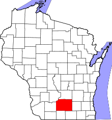
 Location in Dane County and the state of Wisconsin. | |
| Coordinates: 43°6′39″N 89°22′6″W / 43.11083°N 89.36833°WCoordinates: 43°6′39″N 89°22′6″W / 43.11083°N 89.36833°W | |
| Country | United States |
| State | Wisconsin |
| County | Dane |
| Area[1] | |
| • Total | 0.69 sq mi (1.79 km2) |
| • Land | 0.69 sq mi (1.79 km2) |
| • Water | 0 sq mi (0 km2) |
| Elevation[2] | 876 ft (267 m) |
| Population (2010)[3] | |
| • Total | 1,313 |
| • Estimate (2012[4]) | 1,344 |
| • Density | 1,902.9/sq mi (734.7/km2) |
| Time zone | Central (CST) (UTC-6) |
| • Summer (DST) | CDT (UTC-5) |
| Area code(s) | 608 |
| FIPS code | 55-48750[5] |
| GNIS feature ID | 1568959[2] |
Maple Bluff is a village in Dane County, Wisconsin, United States. The population was 1,313 at the 2010 census. A suburb of Madison, it is part of the Madison Metropolitan Statistical Area.
Maple Bluff is the site of the Wisconsin Governor's Mansion, the residence of the governor of Wisconsin and his or her family. The Robert M. La Follette House is also in Maple Bluff.
Municipal services
Maple Bluff is served by the Maple Bluff Police Department. The Maple Bluff Fire Department provides fire protection service and non-transporting emergency medical service to the village. Ambulance transport services are contracted to a private ambulance provider.
Geography
Maple Bluff is located at 43°6′39″N 89°22′6″W / 43.11083°N 89.36833°W (43.110945, -89.368263).[6]
According to the United States Census Bureau, the village has a total area of 0.69 square miles (1.79 km2), all of it land.[1]
Demographics
| Historical population | |||
|---|---|---|---|
| Census | Pop. | %± | |
| 1940 | 862 | — | |
| 1950 | 1,361 | 57.9% | |
| 1960 | 1,565 | 15.0% | |
| 1970 | 1,974 | 26.1% | |
| 1980 | 1,351 | −31.6% | |
| 1990 | 1,352 | 0.1% | |
| 2000 | 1,358 | 0.4% | |
| 2010 | 1,313 | −3.3% | |
| Est. 2015 | 1,340 | [7] | 2.1% |
2010 census
As of the census[3] of 2010, there were 1,313 people, 547 households, and 401 families residing in the village. The population density was 1,902.9 inhabitants per square mile (734.7/km2). There were 592 housing units at an average density of 858.0 per square mile (331.3/km2). The racial makeup of the village was 95.9% White, 1.1% African American, 0.3% Native American, 0.8% Asian, 0.5% from other races, and 1.4% from two or more races. Hispanic or Latino of any race were 1.4% of the population.
There were 681 households of which 29.1% had children under the age of 18 living with them, 67.5% were married couples living together, 3.5% had a female householder with no husband present, 2.4% had a male householder with no wife present, and 26.7% were non-families. 20.5% of all households were made up of individuals and 6.5% had someone living alone who was 65 years of age or older. The average household size was 2.40 and the average family size was 2.79.
The median age in the village was 48 years. 22.3% of residents were under the age of 18; 3.2% were between the ages of 18 and 24; 19.3% were from 25 to 44; 38.8% were from 45 to 64; and 16.4% were 65 years of age or older. The gender makeup of the village was 49.4% male and 50.6% female.
2000 census
As of the census[5] of 2000, there were 1,358 people, 541 households, and 407 families residing in the village. The population density was 1,944.1 people per square mile (749.0/km²). There were 557 housing units at an average density of 797.4 per square mile (307.2/km²). The racial makeup of the village was 97.13% White, 1.33% African American, 0.22% Native American, 0.37% Asian, 0.29% from other races, and 0.66% from two or more races. Hispanic or Latino of any race were 0.66% of the population.
There were 541 households out of which 31.4% had children under the age of 18 living with them, 69.7% were married couples living together, 4.3% had a female householder with no husband present, and 24.6% were non-families. 19.0% of all households were made up of individuals and 9.1% had someone living alone who was 65 years of age or older. The average household size was 2.51 and the average family size was 2.88.
In the village the population was spread out with 24.0% under the age of 18, 4.3% from 18 to 24, 22.2% from 25 to 44, 31.6% from 45 to 64, and 17.9% who were 65 years of age or older. The median age was 45 years. For every 100 females there were 93.2 males. For every 100 females age 18 and over, there were 91.5 males.
The median income for a household in the village was $111,400, and the median income for a family was $129,961. Males had a median income of $83,074 versus $50,000 for females. The per capita income for the village was $66,380. About 1.7% of families and 2.5% of the population were below the poverty line, including 1.2% of those under age 18 and 2.1% of those age 65 or over.
Notable people
- Connie Carpenter-Phinney - Olympic speed skater, Olympic gold medal winner in road cycling
- Thomas E. Coleman - Chairman of the Republican Party of Wisconsin
- Chris Farley - comedian, actor, Saturday Night Live alumnus
- Jim Montgomery - Olympic gold medal winner in swimming
- Bradley Whitford - actor
- Jane Wiedlin - rhythm guitarist of The Go-Go's, actress
- Thornton Wilder - Pulitzer Prize-winning author and playwright
References
- 1 2 "US Gazetteer files 2010". United States Census Bureau. Retrieved 2012-11-18.
- 1 2 "US Board on Geographic Names". United States Geological Survey. 2007-10-25. Retrieved 2008-01-31.
- 1 2 "American FactFinder". United States Census Bureau. Retrieved 2012-11-18.
- ↑ "Population Estimates". United States Census Bureau. Retrieved 2013-06-24.
- 1 2 "American FactFinder". United States Census Bureau. Retrieved 2008-01-31.
- ↑ "US Gazetteer files: 2010, 2000, and 1990". United States Census Bureau. 2011-02-12. Retrieved 2011-04-23.
- ↑ "Annual Estimates of the Resident Population for Incorporated Places: April 1, 2010 to July 1, 2015". Retrieved July 2, 2016.
- ↑ "Census of Population and Housing". Census.gov. Retrieved June 4, 2015.
External links
| Surrounding communities |
|  | ||||||
|---|---|---|---|---|---|---|---|---|
| Counties | ||||||||