Devil's Golf Course
Coordinates: 36°19′42″N 116°51′36″W / 36.32833°N 116.86000°W[1]

The Devil's Golf Course is a large salt pan on the floor of Death Valley, located in the Mojave Desert within Death Valley National Park. The park is in eastern California.
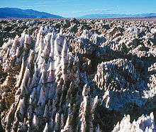
It was named after a line in the 1934 National Park Service guide book to Death Valley National Monument, which stated that "Only the devil could play golf" on its surface, due to a rough texture from the large halite salt crystal formations.[2]
Description
Lake Manly once covered the valley to a depth of 30 feet (9.1 m). The salt in the Devil's Golf Course consists of the minerals that were dissolved in the lake's water and left behind in the Badwater Basin when the lake evaporated. With an elevation several feet above the valley floor at Badwater, the Devil's Golf Course remains dry, allowing weathering processes to sculpt the salt there into complicated formations.
Through exploratory holes drilled by the Pacific Coast Borax Company, prior to Death Valley becoming a national monument in 1934, it was discovered that the salt and gravel beds of the Devil's Golf Course extend to a depth of more than 1,000 feet (300 m). Later studies suggest that in places the depth ranges up to 9,000 feet (2,700 m).[3]
Access
Devil's Golf Course can be reached from Badwater Road via a 1.3-mile (2.1 km) gravel drive, closed in wet weather. It should not be confused with an actual golf course in Furnace Creek, also in Death Valley.
See also
References
- ↑ "Devils Golf Course". Geographic Names Information System. United States Geological Survey.
- ↑ Death Valley National Park – Furnace Creek Area (U.S. National Park Service). Nps.gov (2011-04-15). Retrieved on 2011-05-06.
- ↑ Death Valley Salt Pan and other playas
| Wikimedia Commons has media related to Devils Golf Course. |