Dianguirdé
| Dianguirdé | |
|---|---|
| Commune and town | |
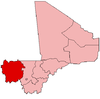
 Dianguirdé Location in Mali | |
| Coordinates: ML 14°29′19″N 9°00′58″W / 14.48861°N 9.01611°WCoordinates: ML 14°29′19″N 9°00′58″W / 14.48861°N 9.01611°W | |
| Country |
|
| Region | Kayes Region |
| Cercle | Diéma Cercle |
| Elevation | 254 m (833 ft) |
| Population (2009 census)[1] | |
| • Total | 12,684 |
| Time zone | GMT (UTC+0) |
Dianguirdé is a rural commune and small town in the Cercle of Diéma in the Kayes Region of western Mali. The commune contains 14 villages and hamlets. In the 2009 census the commune had a population of 12,684.
References
- ↑ Resultats Provisoires RGPH 2009 (Région de Kayes) (PDF) (in French), République de Mali: Institut National de la Statistique.
External links
Plan de Sécurite Alimentaire Commune Rurale de Dianguirdé 2007-2011 (PDF) (in French), Commissariat à la Sécurité Alimentaire, République du Mali, USAID-Mali, 2006.
This article is issued from Wikipedia - version of the 8/21/2013. The text is available under the Creative Commons Attribution/Share Alike but additional terms may apply for the media files.